History
The Embudo Stream Gauging Station was established as part of the United States Geologic Survey Irrigation Survey, a project to map water basins and collect streamflow data in an effort to make informed irrigation infrastructure decisions, directed by Clarence Dutton. [1] While Dutton was able to locate topographers and irrigation engineers for the survey, he was not able to locate hydrographers, so a training camp was established at Embudo, New Mexico. Engineers, including camp director Frederick H.Newell, first arrived in December 1888. [2] While canvas tents and cots were purchased, the unanticipated cold of the higher elevation site led to the use of shallow trenches with blankets rather than cots and small cave dug in a nearby hillside for sleeping. [3]

Clarence Edward Dutton was an American geologist and US Army officer. Dutton was born in Wallingford, Connecticut on May 15, 1841. He graduated from Yale College in 1860 and took postgraduate courses there until 1862, when he enlisted in the 21st Connecticut Volunteer Infantry; he fought at Fredericksburg, Suffolk, Nashville and Petersburg.

Frederick Haynes Newell, served as the first Director of the United States Reclamation Service, was born in Bradford, Pennsylvania. He graduated in 1885 from the Massachusetts Institute of Technology and after field experience in Colorado and other states was appointed on October 2, 1888, as Assistant Hydraulic Engineer of the United States Geological Survey, being the first aide designated under Major John Wesley Powell to investigate the extent to which the arid regions of the United States might be reclaimed by irrigation. He was subsequently appointed Chief of the Hydrographic Branch.
By early March 1889, the camp hosted 21 residents, including 15 students. The training period ended in April 1889 with ten of the students taking on hydrographer positions in the Irrigation Survey. Stream measurements were continued by the local railroad agent until 1904 and were then discontinued. Measurements resumed in 1912 by a new railroad agent, and in 1915 the station operation was taken on by the State of New Mexico. The USGS resumed operation of the stream gauging station in July 1931. [2]

The Rio Grande is one of the principal rivers in the southwest United States and northern Mexico. The Rio Grande begins in south-central Colorado in the United States and flows to the Gulf of Mexico. After passing through the length of New Mexico along the way, it forms part of the Mexico–United States border. According to the International Boundary and Water Commission, its total length was 1,896 miles (3,051 km) in the late 1980s, though course shifts occasionally result in length changes. Depending on how it is measured, the Rio Grande is either the fourth- or fifth-longest river system in North America.

The Little Colorado River is a tributary of the Colorado River in the U.S. state of Arizona, providing the principal drainage from the Painted Desert region. Together with its major tributary, the Puerco River, it drains an area of about 26,500 square miles (69,000 km2) in eastern Arizona and western New Mexico. Although it stretches almost 340 miles (550 km), only the headwaters and the lowermost reaches flow year-round. Between St. Johns and Cameron, most of the river is a wide, braided wash, only containing water after heavy snowmelt or flash flooding.

The Merced River, in the central part of the U.S. state of California, is a 145-mile (233 km)-long tributary of the San Joaquin River flowing from the Sierra Nevada into the San Joaquin Valley. It is most well known for its swift and steep course through the southern part of Yosemite National Park, where it is the primary watercourse flowing through Yosemite Valley. The river's character changes dramatically once it reaches the plains of the agricultural San Joaquin Valley, where it becomes a slow-moving meandering stream.

The San Juan River is a major tributary of the Colorado River in the Southwestern United States, providing the chief drainage for the Four Corners region of Colorado, New Mexico, Utah and Arizona. Originating as snowmelt in the San Juan Mountains of Colorado, it flows 383 miles (616 km) through the deserts of northern New Mexico and southeastern Utah to join the Colorado River at Glen Canyon. The river drains a high, arid region of the Colorado Plateau and along its length it is often the only significant source of fresh water for many miles. The San Juan is also one of the muddiest rivers in North America, carrying an average of 25 million US tons of silt and sediment each year.

The West Branch Delaware River is one of two branches that form the Delaware River. It is approximately 90 mi (144 km) long, and flows through the U.S. states of New York and Pennsylvania. It winds through a mountainous area of New York in the western Catskill Mountains for most of its course, before joining the East Branch along the northeast border of Pennsylvania with New York. Midway or so it is empounded by the Cannonsville Dam to form the Cannonsville Reservoir, both part of the New York City water supply system for delivering drinking water to the City.

The San Gabriel River is a mostly urban waterway flowing 58 miles (93 km) southward through Los Angeles and Orange Counties, California in the United States. It is the central of three major rivers draining the Greater Los Angeles Area, the others being the Los Angeles River and Santa Ana River. The river's watershed stretches from the rugged San Gabriel Mountains to the heavily developed San Gabriel Valley and a significant part of the Los Angeles coastal plain, emptying into the Pacific Ocean between the cities of Long Beach and Seal Beach.

Dixon is an unincorporated community located in Rio Arriba County in the U.S. state of New Mexico, on NM Highway 75, just east of NM Highway 68 in the north-central part of the state, at Latitude 36.20 & Longitude -105.89. The elevation of Dixon is 6028 feet above sea level. It is on the banks of the Embudo River, a tributary of the Rio Grande. The Embudo flows into the Rio Grande two miles (3.2 km) downstream from Dixon. According to the 2010 Census the population is 926, with 70% of residents identifying as Hispanic. Many non-Hispanics have made their homes here since the mid-1960s.

Larrys Creek is a 22.9-mile-long (36.9 km) tributary of the West Branch Susquehanna River in Lycoming County in the U.S. state of Pennsylvania. A part of the Chesapeake Bay drainage basin, its watershed drains 89.1 square miles (231 km2) in six townships and a borough. The creek flows south from the dissected Allegheny Plateau to the Ridge-and-valley Appalachians through sandstone, limestone, and shale from the Devonian, Mississippian, and Pennsylvanian periods.
Streamflow, or channel runoff, is the flow of water in streams, rivers, and other channels, and is a major element of the water cycle. It is one component of the runoff of water from the land to waterbodies, the other component being surface runoff. Water flowing in channels comes from surface runoff from adjacent hillslopes, from groundwater flow out of the ground, and from water discharged from pipes. The discharge of water flowing in a channel is measured using stream gauges or can be estimated by the Manning equation. The record of flow over time is called a hydrograph. Flooding occurs when the volume of water exceeds the capacity of the channel.

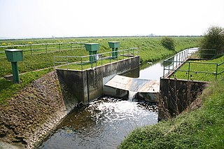
Embudo is an unincorporated community in Rio Arriba County, New Mexico, United States. It is on NM State Road 68. The Embudo Station is located 2.9 miles south of the intersection of NM State Road 75, near where the Embudo River flows into the Rio Grande.
The Chili Line, officially known as the Santa Fe Branch, was a 3 ft narrow-gauge branch of the Denver and Rio Grande Western Railroad (D&RGW). It ran 125.6 miles (202.1 km) from Antonito, Colorado, to Santa Fe, New Mexico. The Denver and Rio Grande Railway (D&RG) began construction of the line in 1880 and completed the line from Antonito to Española, New Mexico, but could not build any further because of an agreement with the Atchison, Topeka and Santa Fe Railroad (AT&SF). The Texas, Santa Fe and Northern Railroad was incorporated to complete the line, and the line between Española and Santa Fe opened in 1886 and was transferred to the Denver and Rio Grande shortly thereafter. The D&RGW closed the Chili Line in 1941 because of competition from road transportation, and the line was abandoned shortly thereafter.
Sublette is a railroad town in northern Rio Arriba County, New Mexico, built as a section station in 1880. It is located north-east of Chama, just south of the Colorado state line and at milepost 306.1 of the former Denver and Rio Grande Western Railroad. When the Denver & Rio Grande Western Railroad abandoned its narrow gauge lines in the late 1960s, two parts of the system were preserved independently: the Cumbres & Toltec Scenic Railroad from Antonito to Chama, including Sublette itself, and the Durango and Silverton Narrow Gauge Railroad. Sublette sits at an elevation of 9,281 feet in the southeastern San Juan Mountains.

Monterey, Pennsylvania, is an unincorporated community which was added to the USGS Geographic Names Information System on August 2, 1979. After the site was surveyed c. 1839 for the never-completed Tapeworm Railroad, the summit community was settled on the Emmitsburg & Waynesboro Turnpike east of the Nichol's Gap Road intersection near the Toll Gate and Brown's Spring and later bypassed by the 20th century Pennsylvania Route 16 highway.

Arthur Powell Davis was an American hydrographer, engineer, geographer, topographer and nephew of John Wesley Powell. He was born on February 9, 1861, in Decatur, Illinois and received his Civil Engineering degree from George Washington University in 1888. Upon graduation he joined his uncle west on the US Geological Survey through New Mexico, Arizona, and California. He then worked in hydrography in places as far flung as China, Puerto Rico, Nicaragua, Panama, and Turkestan. In 1888 he co-founded the National Geographic Society, and in 1907 he was elected president of the Washington Society of Engineers. He served as the Director of the Reclamation Service from 1914 to 1923.

Vallecito, in San Diego County, California is an oasis of cienegas and salt grass along Vallecito Creek and a former settlement on the edge of the Colorado Desert in the Vallecito Valley. Its Spanish name is translated as "little valley". Vallecito was located at the apex of the gap in the Carrizo Badlands created by Carrizo Creek and its wash in its lower reach, to which Vallecito Creek is a tributary. The springs of Vallecito, like many in the vicinity, are a product of the faults that run along the base of the Peninsular Ranges to the west.

Little Delaware River is a river in Delaware County, New York. It begins on the slopes of an unnamed mountain northeast of the Hamlet of Bovina and flows generally eastward before converging with the West Branch Delaware River by the Village of Delhi.

The Rio San Jose is a 90-mile-long (145 km) tributary of the Rio Puerco in the U.S. state of New Mexico.