
Bengkulu, historically known as Bencoolen, is a province of Indonesia. It is located on the southwest coast of Sumatra. It was formed on 18 November 1968 by separating out the area of the historic Bencoolen Residency from the province of South Sumatra under Law No. 9 of 1967 and was finalized by Government Regulation No. 20 of 1968. Spread over 20,130.21 km2, its area is comparable to the European country of Slovenia and it is bordered by the provinces of West Sumatra to the north, Jambi to the northeast, Lampung to the southeast, and South Sumatra to the east, and by the Indian Ocean to the northwest, south, southwest, and west.

Natuna Regency is an islands regency located in the northernmost part of the Province of Riau Islands, Indonesia. It contains at least 154 islands, of which 127 of them are reported as uninhabited. This archipelago, with a land area of 1,978.49 km2 out of a total area of 264,198.37 km2 area, This area is divided into island clusters such as the Natuna Island Cluster and the Serasan Island Cluster. However, several other islands that are not located in the two clusters are spread over a wider area. This division reflects the geographical and administrative location of the district, but there are also other small islands that are outside these two main clusters and are not always included in the grouping. Administratively, this area is divided into 17 districts (kecamatan) which function to facilitate management and services for the local community and support the development of the potential of the region which is rich in natural resources and tourism. This regency also plays an important role in maintaining Indonesia's sovereignty in the northern border area.

Sibolga is a city and a port located in the natural harbour of Sibolga Bay on the west coast of North Sumatra province, in Indonesia.

Simeulue Regency is a regency in the Aceh special region of Indonesia. It occupies the whole island of Simeulue, 150 km off the west coast of Sumatra, which with its many small offshore islands covers a land area of 1,838.1 square kilometres. It had a population of 80,674 at the 2010 census and 92,865 at the 2020 census; the official estimate as at mid 2023 was 97,118.

Great Aceh Regency is a regency of the Indonesian province of Aceh. The regency covers an area of 2,903.49 square kilometres and had a population of 351,418 at the 2010 Census, 391,870 at the 2015 census and 405,535 at the 2020 Census; the official estimate as at mid 2023 was 435,298. The Regency is located at the northwest tip of Sumatra island and surrounds the provincial capital of Banda Aceh, many suburbs of which lie within the Regency. It also includes a number of islands off the northern tip of Sumatra, which comprise Pulo Aceh District within the regency. The seat of the Regency government is the town of Jantho.

The Lingga Regency is a group of 600 islands in Indonesia, located south of Singapore and along both sides of the equator, off the eastern coast of Riau Province on Sumatra island. They are due south of the populated Riau Archipelago, known for the industrial island of Batam and the tourist-frequented island of Bintan, although the Lingga Islands themselves are rarely visited due to the infrequent local transportation. The equator goes through the northern tip of Lingga Island, the main island in the archipelago.

The Batu Islands are an archipelago of Indonesia located in the Indian Ocean, off the west coast of Sumatra, between Nias and Siberut. The three primary islands, of approximately equal size, are Pini, Tanahmasa, and Tanahbala. There are seventy-five smaller islands, of which the largest are Sipika, Tello and Sigata, Simuk and Bojo ; less than half are inhabited. The total land area of the seven administrative districts is 1,201.1 km2. The islands are governed as a part of South Nias regency within North Sumatra province. In Indonesian and Malay, batu means rock or stone.

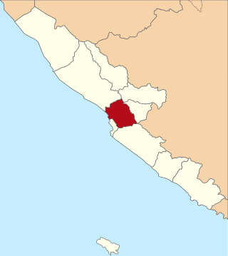
Bengkulu, formerly Bencoolen is the capital of the Indonesian province of Bengkulu. The city is the second largest city on the west coast of Sumatra Island after Padang. Previously this area was under the influence of the kingdom of Inderapura and the Sultanate of Banten. The city also became the place of exile of Sukarno from 1939 to 1942. It covers an area of 151.70 km2 and had a population of 308,544 at the 2010 Census and 373,591 at the 2020 Census; the official estimate as of mid-2023 was 391,117. The city is the only city in Bengkulu Province.

Pesisir Selatan Regency is a regency (kabupaten) of West Sumatra Province of Indonesia. It has an area of 6,049.33 km² and a population of 429,246 at the 2010 Census and 504,418 at the 2020 Census; the official estimate as at mid-2023 was 525,355. The regency seat is at the town of Painan, in IV Jurai District.

North Bengkulu is a regency of Bengkulu Province, Indonesia, on the island of Sumatra. It originally covered much of the northern part of Bengkulu Province, but on 25 February 2003 the most northwesterly districts were split off to form a separate Mukomuko Regency, and on 24 June 2008 the most southeastern districts were likewise split off to create a new Central Bengkulu Regency.

South Bengkulu is a regency of Bengkulu Province, Indonesia, on the island of Sumatra. It originally comprised all of that part of Bengkulu Province situated to the southeast of the city of Bengkulu, but on 25 February 2003 this area was split into three parts, with the most southeastern districts split off to form a new Kaur Regency and the most northwestern districts split off to form a new Seluma Regency. The reduced South Bengkulu Regency now covers 1,219.91 km2, and had a population of 142,940 at the 2010 Census and 166,249 at the 2020 Census; the official estimate as at mid 2023 was 171,463 - comprising 87,297 males and 84,166 females. The regency's administrative centre is the coastal town of Manna.

Aceh Singkil Regency is a regency in the Aceh province of Indonesia. It is situated largely on the island of Sumatra, but also includes the offshore Banyak Islands, the largest of which is Tuangku, with the principal town of Alaban. The regency was created on 20 April 1999 from the former southern districts of South Aceh Regency. Until 2007 it included the large town of Subulussalam, but on 2 January of that year that town was split off to become an autonomous city. It is now bounded to the north by South Aceh Regency and the city of Subulussalam, to the east by North Sumatra Province, and to the south and west by the Indian Ocean. The seat of the Aceh Singkil Regency government is at the port of Singkil on the Sumatra coast. The Regency now covers an area of 1,857.88 km2, and had a population of 102,509 at the 2010 Census, rising to 114,326 at the 2015 Census and to 126,514 at the 2020 Census; the official estimate as at mid 2023 was 135,435.
Central Bengkulu Regency is a regency of Bengkulu Province, Indonesia. It is located on the west coast of the island of Sumatra, and lies immediately to the north and the east of the adjacent city of Bengkulu. It was formed on 24 June 2008 by being split away from the neighbouring North Bengkulu Regency. It covers an area of 1,223.94 km2 and had a population of 98,333 at the 2010 census and 116,706 at the 2020 census; the official estimate as at mid 2023 was 121,139 - comprising 62,078 males and 59,061 females. the administrative centre is at the town of Karang Tinggi.

Langkat Regency is the northernmost regency of North Sumatra Province in Indonesia. Its administrative centre is the town of Stabat. It has a land area of 6,263.29 km2 and its population was 967,535 at the 2010 Census and 1,030,202 at the 2020 Census; the official estimate as at mid 2023 was 1,066,711 - comprising 538,822 males and 527,889 females. Its population is roughly equivalent to that of Djibouti.

Samosir Regency is an inland regency in North Sumatra. It was created on 18 December 2003 by splitting away the western districts of the former Toba Samosir Regency. The regency covers a land area of 1,444.25 square kilometres, including the whole of Samosir Island in the inland sea of Lake Toba. It had a population of 119,653 at the 2010 census and 136,441 at the 2020 Census; the official estimate for mid 2023 was 141,333 - comprising 70,648 males and 70,685 females. Its administrative seat is the town of Pangururan on the west coast of Samosir Island.

West Manggarai Regency is one of the eight regencies which comprise the island of Flores, located in the province of East Nusa Tenggara in Indonesia. The Regency was created on 25 February 2003 by the separation off of the western districts from Manggarai Regency. It covers a land area of 3,141.47 km2, and had a population of 221,703 at the 2010 census, rising to 251,689 at the 2015 Intermediate census and to 256,317 at the 2020 census. The official estimate as at mid 2023 was 278,184. The regency's capital is the town of Labuan Bajo.

West Sumbawa Regency is a Regency (Kabupaten) of the Indonesian Province of West Nusa Tenggara. It is located on the island of Sumbawa and has an area of 1,743.58 km2. The regency was created on 18 December 2003 from what were at that time the westernmost five districts (kecamatan) of Sumbawa Regency. The population at the 2010 Census was 114,754, and at the 2020 Census was 145,798; the official estimate as at mid 2023 was 152,950 comprising 77,030 males and 75,920 females. The capital is the town of Taliwang.

Kaur is the most southern regency of Bengkulu Province, Indonesia, on the west coast of the island of Sumatra. It was created on 25 February 2003 from what were formerly the southeastern districts of the South Bengkulu Regency. It has an area of 2,365.00 km2 and had a population of 107,899 at the 2010 Census and 126,551 at the 2020 Census; the official estimate as at mid 2023 was 131,063 - comprising 67,389 males and 63,674 females. The regency seat is at the town of Bintuhan.
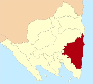
East Lampung Regency is a regency (kabupaten) of Lampung Province, Sumatra, Indonesia. It has an area of 5,325.03 km2 and a population of 951,639 people at the 2010 census and 1,110,340 at the 2020 census. The official estimate as at mid 2023 was 1,114,016 - comprising 566,648 males and 547,368 females. The regency seat is at the town of Sukadana.

North Minahasa Regency is a regency in North Sulawesi, Indonesia. Its capital is Airmadidi. It was originally part of the Minahasa Regency until it was split off and established as a separate regency on 20 November 2003. It covers an area of 1,059.24 km2, and had a population of 188,904 at the 2010 Census; this had risen to 224,993 at the 2020 Census, and the official estimate as at mid 2023 was 231,791. The Regency includes the offshore islands of Bangka and Talisei to the north of Sulawesi, and Mantenang and Naeng Besar to the northwest.


