
Sumatra is one of the Sunda Islands of western Indonesia. It is the largest island that is entirely governed by Indonesia and the sixth-largest island in the world at 473,481 km2.

The Malayo-Polynesian languages are a subgroup of the Austronesian languages, with approximately 385.5 million speakers. The Malayo-Polynesian languages are spoken by the Austronesian peoples of the island nations of Southeast Asia and the Pacific Ocean, with a smaller number in continental Asia, going well into the Malay peninsula. Cambodia, Vietnam and the Chinese island Hainan serve as the northwest geographic outlier. The northernmost geographical outlier does not pass beyond the north of Pattani, which is located in southern Thailand. Malagasy is spoken in the island of Madagascar located off the eastern coast of Africa in the Indian Ocean. Part of the language family shows a strong influence of Sanskrit and Arabic as the western part of the region has been a stronghold of Hinduism, Buddhism and, later, Islam.

Bengkulu is a province of Indonesia. It is located on the southwest coast of Sumatra. It was formed on 18 November 1968 by separating out the former Bengkulu Residency area from the province of South Sumatra under Law No. 9 of 1967 and was finalised by Government Regulation No. 20 of 1968. Spread over 19,813 km2, it is bordered by the provinces of West Sumatra to the north, Jambi to the northeast, Lampung to the southeast, and South Sumatra to the east, and by the Indian Ocean to the northwest, south, southwest, and west.

Enggano Island is about 100 km southwest of Sumatra, Indonesia. It is one of the 92 officially listed outlying islands of Indonesia.
The sunburned rat is a species of rat from Enggano Island in Indonesia. It is only known from the holotype and has not been recorded since its description in 1940.

The term Proto-Malay, which translates to Melayu Asli or Melayu Purba or Melayu Tua, refers to Austronesian speakers, possibly from mainland Asia, who moved to the Malay peninsula and Malay archipelago in a long series of migrations between 2500 and 1500 BC, and in one model the first of two migrations of early Malay speakers, before that of the Deutero-Malays. The Proto-Malays are the ancestors of the Malays in the modern Malaysia and Indonesia.

Bengkulu is the capital of the Indonesian province of Bengkulu. The city is the second largest city on the west coast of Sumatra Island after Padang. Previously this area is under the influence of the kingdom of Inderapura and the Sultanate of Banten. The city also became the exile of Sukarno during the period of 1939 - 1942. It had a population of 308,756 at the 2010 Census, the latest estimate is 328,827. The city is also the largest city of Bengkulu Province.
The Enggano scops owl is an owl endemic to Enggano Island, Indonesia.
The Enggano rat is a species of rodent in the family Muridae. It is found only on Enggano Island, Indonesia. It is critically endangered.
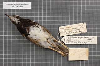
The Enggano thrush is a species of bird in the family Turdidae. It is endemic to rainforests on Enggano Island off Sumatra in Indonesia. It has traditionally been considered a subspecies of the chestnut-capped thrush.

Elio Modigliani was an Italian anthropologist, zoologist, explorer, and plant collector.

The 2000 Enggano earthquake struck at 23:28 local time on June 4 with a moment magnitude of 7.9 and a maximum Mercalli intensity of VI (Strong). The event occurred off the coast of southern Sumatra, Indonesia near Enggano Island. There were more than 100 fatalities and up to 2,585 injuries. Over 730 aftershocks shocked the area afterwards, one just eleven minutes after the mainshock.
The Enggano language, or Engganese, is an Austronesian language spoken on Enggano Island off the southwestern coast of Sumatra, Indonesia.
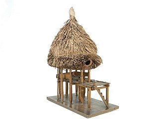
The traditional architecture of the Indonesian island of Enggano until the early 20th century consisted of unusual round beehive-shaped houses.

The Enggano people are an isolated, but contacted, tribe which inhabits Enggano Island. Enggano Island is a small island located adjacent to the southwest coast of Sumatra in Indonesia. The population of Enggano people is not closely tracked. As such, no population estimates beyond the year 2000 appear to exist. Furthermore, the estimates from 1990 and 2000 are not in agreement. The source for the year 2000 estimates that there were 1,500 Enggano people inhabiting the island. While the 1999 source estimates that there were approximately 1,000 Enggano people inhabiting the island. However, both sources agree that the population is likely to continue decreasing.

Balato is a sword that originates from Nias, an island off the west coast of North Sumatra, Indonesia.
The Pulau Enggano dwarf gecko is a species of gecko. It is endemic to Enggano Island, Indonesia.
Barhau is the largest village and one of the two main population centers of Enggano Island, Indonesia, alongside Kayaapu, located in its northwestern extremity. As with the other three villages on the island, reaching it is difficult mainly due to the island's remoteness and thick vegetation that can be found all across the island.
