An intraplate earthquake is an earthquake that occurs in the interior of a tectonic plate, in contrast to an interplate earthquake on the boundary of a tectonic plate. It is also called an intraslab earthquake, especially when occurring in a microplate.

The Cascadia subduction zone is a 960 km (600 mi) fault at a convergent plate boundary, about 100–200 km (70–100 mi) off the Pacific coast, that stretches from northern Vancouver Island in Canada to Northern California in the United States. It is capable of producing 9.0+ magnitude earthquakes and tsunamis that could reach 30 m (98 ft). The Oregon Department of Emergency Management estimates shaking would last 5–7 minutes along the coast, with strength and intensity decreasing further from the epicenter. It is a very long, sloping subduction zone where the Explorer, Juan de Fuca, and Gorda plates move to the east and slide below the much larger mostly continental North American plate. The zone varies in width and lies offshore beginning near Cape Mendocino, Northern California, passing through Oregon and Washington, and terminating at about Vancouver Island in British Columbia.

A harmonic tremor is a sustained release of seismic and infrasonic energy typically associated with the underground movement of magma, the venting of volcanic gases from magma, or both in volcanoes, and with repetitive stick-slip or other impulsive activity in non-volcanic systems. It is a long-duration release of seismic energy, often containing distinct spectral lines. Volcanic tremor often precedes or accompanies a volcanic eruption. Being a long-duration continuous signal from a temporally extended source tremor contrasts distinctly with transient and often impulsive sources of seismic radiation typically associated with earthquakes and explosions.
An interplate earthquake is an earthquake that occurs at the boundary between two tectonic plates. Earthquakes of this type account for more than 90 percent of the total seismic energy released around the world. If one plate is trying to move past the other, they will be locked until sufficient stress builds up to cause the plates to slip relative to each other. The slipping process creates an earthquake with relative displacement on either side of the fault, resulting in seismic waves which travel through the Earth and along the Earth's surface. Relative plate motion can be lateral as along a transform fault boundary, vertical if along a convergent boundary or a divergent boundary, and oblique, with horizontal and lateral components at the boundary. Interplate earthquakes associated at a subduction boundary are called megathrust earthquakes, which include most of the Earth's largest earthquakes.
Megathrust earthquakes occur at convergent plate boundaries, where one tectonic plate is forced underneath another. The earthquakes are caused by slip along the thrust fault that forms the contact between the two plates. These interplate earthquakes are the planet's most powerful, with moment magnitudes (Mw) that can exceed 9.0. Since 1900, all earthquakes of magnitude 9.0 or greater have been megathrust earthquakes.
A slow earthquake is a discontinuous, earthquake-like event that releases energy over a period of hours to months, rather than the seconds to minutes characteristic of a typical earthquake. First detected using long term strain measurements, most slow earthquakes now appear to be accompanied by fluid flow and related tremor, which can be detected and approximately located using seismometer data filtered appropriately. That is, they are quiet compared to a regular earthquake, but not "silent" as described in the past.

The Queen Charlotte Fault is an active transform fault that marks the boundary of the North American plate and the Pacific plate. It is Canada's right-lateral strike-slip equivalent to the San Andreas Fault to the south in California. The Queen Charlotte Fault forms a triple junction south with the Cascadia subduction zone and the Explorer Ridge. The Queen Charlotte Fault (QCF) forms a transpressional plate boundary, and is as active as other major transform fault systems in terms of slip rates and seismogenic potential. It sustains the highest known deformation rates among continental or continent-ocean transform systems globally, accommodating greater than 50mm/yr dextral offset. The entire approximately 900 km offshore length has ruptured in seven greater than magnitude 7 events during the last century, making the cumulative historical seismic moment release higher than any other modern transform plate boundary system.

The Okinawa plate, or Okinawa platelet, is a minor continental tectonic plate in the northern and eastern hemispheres stretching from the northern end of Taiwan to the southern tip of the island of Kyūshū. The Okinawa plate hosts typical earthquakes, like the 1911 Kikai Island earthquake, and various types of slow earthquakes, including low frequency earthquakes, very low frequency earthquakes, tremor, and slow slip events.
The 1995 Antofagasta earthquake occurred on July 30 at 05:11 UTC with a moment magnitude of 8.0 and a maximum Mercalli intensity of VII. The Antofagasta Region in Chile was affected by a moderate tsunami, with three people killed, 58 or 59 injured, and around 600 homeless. Total damage from the earthquake and tsunami amounted to $1.791 million.

The 1861 Sumatra earthquake occurred on 16 February and was the last in a sequences of earthquakes that ruptured adjacent parts of the Sumatran segment of the Sunda megathrust. It caused a devastating tsunami which led to several thousand fatalities. The earthquake was felt as far away as the Malay peninsula and the eastern part of Java. The rupture area for the 2005 Nias–Simeulue earthquake is similar to that estimated for the 1861 event.

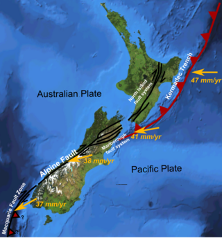
The North Island Fault System (NIFS) is a set of southwest–northeast trending seismically-active faults in the North Island of New Zealand that carry much of the dextral strike-slip component of the oblique convergence of the Pacific Plate with the Australian Plate. However despite at least 3 km (1.9 mi) of uplift of the axial ranges in the middle regions of the fault system during the last 10 million years most of the shortening on this part of the Hikurangi Margin is accommodated by subduction.
The 1935 Sumatra earthquake occurred at on 28 December. It had a magnitude of 7.7 and a maximum felt intensity of VII (Damaging) on the European macroseismic scale. It triggered a minor tsunami.
Susan Y. Schwartz is a scientist at the University of California, Santa Cruz known for her research on earthquakes, through field projects conducted in locations in Costa Rica and the San Andreas Fault.
The 1968 Hyūga-nada earthquake occurred on April 1 at . The earthquake had a magnitude of 7.5, and the epicenter was located in Hyūga-nada Sea, off the islands of Kyushu and Shikoku, Japan. The magnitude of this earthquake was also given as 7.5. A tsunami was observed. One person was killed, and 22 people were reported injured. The intensity reached shindo 5 in Miyazaki and Kōchi.
The 1911 Guerrero earthquake occurred on December 16 at near the coast of Guerrero, Mexico along the Mexican subduction zone. The earthquake's energy was calculated using several different magnitude scales with an estimated moment magnitude of 7.6 and a surface-wave magnitude of 7.8. Following the event, telegraphy reports came in from a broad area of Mexico. Cities from Guadalajara, Mérida, and Tapachula all reported the tremors. The earthquake lasted over two minutes and resulted in the deaths of 28 people.

The Hikurangi Margin is New Zealand's largest subduction zone and fault.

Laura Martin Wallace is a geodetic principal scientist who works between the University of Texas at Austin and GNS Science in New Zealand. She was elected Fellow of the Royal Society Te Apārangi in 2018.
Anne Sheehan is a geologist known for her research using seismometer data to examine changes in the Earth's crust and mantle.

Oblique subduction is a form of subduction for which the convergence direction differs from 90° to the plate boundary. Most convergent boundaries involve oblique subduction, particularly in the Ring of Fire including the Ryukyu, Aleutian, Central America and Chile subduction zones. In general, the obliquity angle is between 15° and 30°. Subduction zones with high obliquity angles include Sunda trench and Ryukyu arc.

The earthquake cycle refers to the phenomenon that earthquakes repeatedly occur on the same fault as the result of continual stress accumulation and periodic stress release. Earthquake cycles can occur on a variety of faults including subduction zones and continental faults. Depending on the size of the earthquake, an earthquake cycle can last decades, centuries, or longer. The Parkfield portion of the San Andreas fault is a well-known example where similarly located M6.0 earthquakes have been instrumentally recorded every 30–40 years.


