Errekalde

Last updated
Errekalde
District

Errekalde.svg

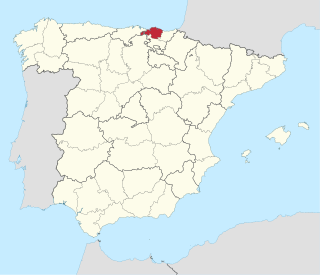
Errekalde district is highlighted in blue in this map of the districts of Bilbao.
Country Spain
Autonomous community Basque Country
Province Biscay
Comarca Greater Bilbao
Municipality Bilbao
Area
  Total 6.96 km2 (2.69 sq mi)
Population (2016)
  Total 47,245
  Density 6,800/km2 (18,000/sq mi)

Recalde (or Errekalde) is the seventh district of the city of Bilbao (Biscay), in the Spanish Basque Country. It is divided into the following neighborhoods: Amezola, Iralabarri, Iturrigorri-Peñascal, Rekaldeberri-Larraskitu and Uretamendi.

Bilbao Municipality in Basque Country, Spain

Bilbao is a city in northern Spain, the largest city in the province of Biscay and in the Basque Country as a whole. It is also the largest city proper in northern Spain. Bilbao is the tenth largest city in Spain, with a population of 345,141 as of 2015. The Bilbao metropolitan area has roughly 1 million inhabitants, making it one of the most populous metropolitan areas in northern Spain; with a population of 875,552 the comarca of Greater Bilbao is the fifth-largest urban area in Spain. Bilbao is also the main urban area in what is defined as the Greater Basque region.

Biscay Province of Spain

Biscay is a province of Spain located just south of the Bay of Biscay. The name also refers to a historical territory of the Basque Country, heir of the ancient Lordship of Biscay. Its capital city is Bilbao. It is one of the most prosperous and important provinces of Spain as a result of the massive industrialization in the last years of the 19th century and first half of the 20th century. Since the deep deindustrialization of the 1970s, the economy has come to rely more on the services sector.

Spain Kingdom in Southwest Europe

Spain, officially the Kingdom of Spain, is a country mostly located in Europe. Its continental European territory is situated on the Iberian Peninsula. Its territory also includes two archipelagoes: the Canary Islands off the coast of Africa, and the Balearic Islands in the Mediterranean Sea. The African enclaves of Ceuta, Melilla, and Peñón de Vélez de la Gomera make Spain the only European country to have a physical border with an African country (Morocco). Several small islands in the Alboran Sea are also part of Spanish territory. The country's mainland is bordered to the south and east by the Mediterranean Sea except for a small land boundary with Gibraltar; to the north and northeast by France, Andorra, and the Bay of Biscay; and to the west and northwest by Portugal and the Atlantic Ocean.

The meaning of Errekalde in Basque is 'near the creek' (erreka 'creek' and alde 'near').

Basque language language of the Basque people

Basque (; euskara[eus̺ˈkaɾa]) is a language spoken in the Basque Country, a region that straddles the westernmost Pyrenees in adjacent parts of northern Spain and southwestern France. Linguistically, Basque is unrelated to the other languages of Europe and is a language isolate to any other known living language. The Basques are indigenous to, and primarily inhabit, the Basque Country. The Basque language is spoken by 28.4% (751,500) of Basques in all territories. Of these, 93.2% (700,300) are in the Spanish area of the Basque Country and the remaining 6.8% (51,200) are in the French portion.

In 2016 the district's population was 47,245 in an area of 6.96 square kilometers.

Sights

The new residential developments of Ametzola. Ametzola1.jpg
The new residential developments of Ametzola.
The new residential developments of Ametzola. 

Related Research Articles

Benson, New York Town in New York, United States

Benson is a town in Hamilton County, New York, United States. The population was 192 at the 2010 census. The town is on the south border of Hamilton County and is northwest of Schenectady. The current Town Supervisor is John M. Stortecky.

Mendaro is a town located in the province of Gipuzkoa, in the Autonomous Community of Basque Country, northern Spain.

Zugarramurdi Municipality in Navarre, Spain

Zugarramurdi is a town and municipality located in the province and autonomous community of Navarre in northern Spain. It passed into history as the setting of alleged occult activity featured in the infamous Basque witch trials held in Logroño in the seventeenth century. The town is home to the Basque witch museum and the Cuevas de las Brujas. Every year, spectacular fires are lit in the caves near Zugarramurdi for the celebration of the ‘day of the witch’ on the summer solstice.

Hasparren Commune in Nouvelle-Aquitaine, France

Hasparren is a commune in the Pyrénées-Atlantiques department in south-western France. A resident of Hasparren is known as a 'Haspandar'.

Saint-Étienne-de-Baïgorry Commune in Nouvelle-Aquitaine, France

Saint-Étienne-de-Baïgorry is a commune in the Pyrénées-Atlantiques department in south-western France, located at the same time in the former province of Lower Navarre. It borders the municipality of Baztan to the west.

Viodos-Abense-de-Bas Commune in Nouvelle-Aquitaine, France

Viodos-Abense-de-Bas is a commune in the Pyrénées-Atlantiques department in south-western France.

Florissant, Colorado CDP in Colorado, USA

Florissant is a census-designated place and a U.S. Post Office in Teller County, Colorado, United States. The population as of the 2010 Census was 104. Florissant, Colorado, was named after Florissant, Missouri, the hometown of Judge James Castello, an early settler. The word florissant is the gerund of the French verb fleurir, which roughly means to flourish, to flower, or to blossom.

Abando District in Basque Country, Spain

Abando, formerly known as San Vicente de Abando, is one of the eight districts of Bilbao, Basque Country (Spain). It covers most of the city's centre, located on the left bank of the estuary of Bilbao. It is the only district of Bilbao with all of its land completely urbanised. Abando was originally an elizate and also a municipality until 1876, when part of it was annexed to Bilbao, the rest of the elizate's municipal land was integrated into Bilbao in 1890. In 2016 the population was 50,903.

Scotia, Pennsylvania human settlement in the United States of America

Scotia was a village in Patton Township, Centre County, Pennsylvania, at 40°47′59″N77°56′46″W. Although the community was called Scotia, the name of the local post office was Benore.

Miskovice village in Kutná Hora District of Central Bohemian region

Miskovice is a village in Kutná Hora District, Central Bohemia, Czech Republic, located 4.5 km west of Kutná Hora. On the date August 8, 2006 it has 873 inhabitants. First written notice about village is from year 1131.

Sunfair, California Unincorporated community in California, United States

Sunfair is an unincorporated community in the Mojave Desert, within San Bernardino County, California.

Sweetwater Creek is a stream in northern Texas and western Oklahoma. It is a tributary to the North Fork of the Red River.

Deers Mill, Indiana Unincorporated community in Indiana, United States

Deer's Mill is an unincorporated community in Ripley Township, Montgomery County, in the U.S. state of Indiana.

Krasne, Przeworsk County Village in Subcarpathian, Poland

Krasne is a village in the administrative district of Gmina Adamówka, within Przeworsk County, Subcarpathian Voivodeship, in south-eastern Poland. It lies approximately 3 kilometres (2 mi) east of Adamówka, 27 km (17 mi) north-east of Przeworsk, and 58 km (36 mi) north-east of the regional capital Rzeszów.

Moyua (Metro Bilbao) metro station in Bilbao, Spain

Moyua is a station of line 1 and line 2 of Metro Bilbao. The station is located in the neighbourhood of Abando, in the district with the same name. The station is located under the Moyua Plaza, named after Federico Moyua, mayor of Bilbao during the early 20th century.

Botumagyabu Village in Western Region (Ghana), Ghana

Botumegyabu is a village in Shama District in the Western Region of Ghana near the town Sekondi. Botumegyabu is in the Essikado-Ketan constituency of the Western region of Ghana. It is mainly a dormitory village.

Elrama is a census-designated place located in Union Township, Washington County in the state of Pennsylvania. The community is located in far eastern tip of Union Township in Washington County, near the Monongahela River, along Pennsylvania Route 837. As of the 2010 census the population was 307 residents.

Sand Creek is a tributary of the San Diego River in San Diego County, California.

Lock Berlin is a hamlet in the Town of Galen, Wayne County, New York, United States. It is located 4 miles (6 km) west of the Village of Clyde and 3 miles (5 km) northeast of the hamlet of Lyons, at an elevation of 404 feet. The primary cross roads where the hamlet is located are Old Route 31, Stokes Road, Lock Berlin Road and Maple Street. N.Y. Route 31 passes just south of Lock Berlin.

Blackberry Creek is a stream in Jasper and Barton counties of southwest Missouri. It is a tributary of Spring River.

References

Coordinates: 43°15′07″N2°56′46″W / 43.25194°N 2.94611°W / 43.25194; -2.94611

Geographic coordinate system Coordinate system

A geographic coordinate system is a coordinate system that enables every location on Earth to be specified by a set of numbers, letters or symbols. The coordinates are often chosen such that one of the numbers represents a vertical position and two or three of the numbers represent a horizontal position; alternatively, a geographic position may be expressed in a combined three-dimensional Cartesian vector. A common choice of coordinates is latitude, longitude and elevation. To specify a location on a plane requires a map projection.