Uribarri

Last updated
Uribarri
District

Uribarri.svg

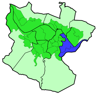
Uribarri district is highlighted in blue in this map of the districts of Bilbao.
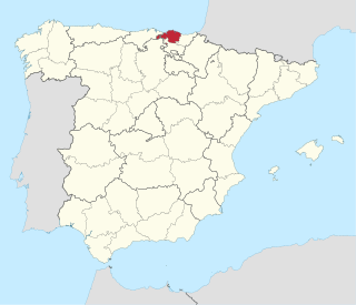
Country Spain
Autonomous community Basque Country
Province Biscay
Comarca Greater Bilbao
Municipality Bilbao
Area
  Total 4.19 km2 (1.62 sq mi)
Population (2016)
  Total 36,181
  Density 8,600/km2 (22,000/sq mi)

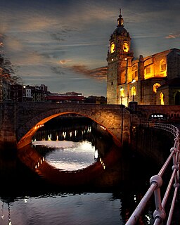
Uribarri is the second district of the city of Bilbao (Biscay), in the Spanish Basque Country. It is divided into the neighbourhoods of Castaños, Matico-Ciudad Jardín, Uríbarri proper and Zurbaran-Arabella. [1]

Bilbao Municipality in Basque Country, Spain

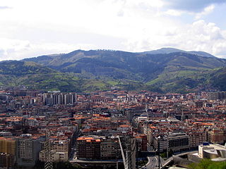
Bilbao is a city in northern Spain, the largest city in the province of Biscay and in the Basque Country as a whole. It is also the largest city proper in northern Spain. Bilbao is the tenth largest city in Spain, with a population of 345,141 as of 2015. The Bilbao metropolitan area has roughly 1 million inhabitants, making it one of the most populous metropolitan areas in northern Spain; with a population of 875,552 the comarca of Greater Bilbao is the fifth-largest urban area in Spain. Bilbao is also the main urban area in what is defined as the Greater Basque region.

Biscay Province of Spain

Biscay is a province of Spain located just south of the Bay of Biscay. The name also refers to a historical territory of the Basque Country, heir of the ancient Lordship of Biscay. Its capital city is Bilbao. It is one of the most prosperous and important provinces of Spain as a result of the massive industrialization in the last years of the 19th century and first half of the 20th century. Since the deep deindustrialization of the 1970s, the economy has come to rely more on the services sector.

Spain Kingdom in Southwest Europe

Spain, officially the Kingdom of Spain, is a country mostly located in Europe. Its continental European territory is situated on the Iberian Peninsula. Its territory also includes two archipelagoes: the Canary Islands off the coast of Africa, and the Balearic Islands in the Mediterranean Sea. The African enclaves of Ceuta, Melilla, and Peñón de Vélez de la Gomera make Spain the only European country to have a physical border with an African country (Morocco). Several small islands in the Alboran Sea are also part of Spanish territory. The country's mainland is bordered to the south and east by the Mediterranean Sea except for a small land boundary with Gibraltar; to the north and northeast by France, Andorra, and the Bay of Biscay; and to the west and northwest by Portugal and the Atlantic Ocean.

Contents

It has an area of 4.19 square kilometers and a population of 36,181 inhabitants. [2]

History

For many years it was a rural area full of farms, belonging to the former parish of Begoña, as a result many street names in the district are former names of farms, like Trauko.

Begoña District in Basque Country, Spain

Begoña or more puristically but also more rarely spelled Begoina, meaning 'the lower foot', is a historical municipality of Biscay that was incorporated to Bilbao in 1925.

This district includes the quarter of La Salve, of historical importance for Bilbao as it was a traditional point for sailors returning to the city.

La Salve bridge in Spain

La Salve is a quarter in the 2nd district of the city of Bilbao, Spain. It gains its name from the fact that sailors, returning from sea, would first see the tower of the Basilica of Begoña at this point as ships returned up the river Nervión, which runs through the city. According to folklore, they would start praying to the Virgin Begoña, the patron saint of the region, thanking her for protecting them during their time at sea.

The area close to the Estuary of Bilbao was urbanized in the late 19th century, when the Paseo del Campo Volantin boulevard was created, lined with mansions of Bilbao's bourgeoisie. The higher lands away from the estuary were urbanized in the 1960s, with high density buildings for working classes.

The Estuary of Bilbao lies at the common mouth of the rivers Nervion, Ibaizabal and Cadagua, that drain most of Biscay and part of Alava in the Basque Country, Spain. In this instance, the Spanish word estuario is used to describe what in English would normally be called part estuary, part tidal river. The estuary becomes a tidal river which extends 16 km (9.9 mi) into the city of Bilbao, starting from the Bilbao Abra bay. It hosts the port of Bilbao throughout its length, although the Port Authority has recently restored most of the upper reaches to Bilbao and other municipalities for their urban regeneration. The port is now being transferred to the seaboard on the coast at Santurtzi and Zierbena.

Places of interest

Bilbao City Hall

The City Hall of the borough of Bilbao, Spain, is located on the right bank of the Estuary of Bilbao across the Puente del Ayuntamiento bascule bridge that links it to the central Abando district.

Zubizuri footbridge

The Zubizuri, also called the Campo Volantin Bridge or Puente del Campo Volantin, is a tied arch footbridge across the Nervion River in Bilbao, Spain. Designed by architect Santiago Calatrava, the bridge links the Campo Volantin right bank and Uribitarte left bank of the river.

Mount Artxanda mountain in Spain

Mount Artxanda is one of the two small mountain ranges that delimit the municipality of Bilbao the other one being Pagasarri. Of the two it is the lower one, the closer one to the center of the city and the one that has suffered from more intense urbanization. The pass of Santo Domingo separates the main part of Artxanda from Monte Avril, 400m high.

Sights

Campo Volantin boulevard and Zubizuri. Nervion.jpg
Campo Volantin boulevard and Zubizuri.
Campo Volantin boulevard and Zubizuri. 

Related Research Articles

Nervión river in Spain

The Nervión river runs through the city of Bilbao, Spain into the Cantabrian Sea. Its lowermost course, downstream of its confluence with the Ibaizabal River, is known as the Estuary of Bilbao.

Northeast Philadelphia Neighborhood of Philadelphia in Philadelphia, Pennsylvania

Northeast Philadelphia, nicknamed Northeast Philly, the Northeast and the Great Northeast, is a section of the City of Philadelphia, Pennsylvania. According to the 2000 Census, the Northeast has a sizable percentage of the city's 1.547 million people—a population of between 300,000 and 450,000, depending on how the area is defined. Beginning in the 1980s, many of the Northeast's middle class children graduated from college and settled in suburbs, especially nearby Bucks County. The Northeast is home to a large working class Irish American population, but is also home to Polish, German, Jewish, Italian, Portuguese and Russian neighborhoods.

Plentzia Municipality in Basque Country, Spain

Plentzia is a town and municipality located in the province of Biscay, in the autonomous community of the Basque Country. The town has 4,146 inhabitants (2008).

Stevens Creek (California) river in the United States of America

Stevens Creek is a creek in Santa Clara County, California. The creek originates in the Santa Cruz Mountains on the western flank of Black Mountain in the Monte Bello Open Space Preserve near the terminus of Page Mill Road at Skyline Boulevard. It flows southeasterly through the Stevens Creek County Park before turning northeast into Stevens Creek Reservoir. It then continues north for 12.5 miles through Cupertino, Los Altos, Sunnyvale and Mountain View before emptying into the San Francisco Bay at the Whisman Slough, near Google's main campus.

Basauri Municipality in Basque Country, Spain

Basauri is a major municipality of Biscay, in the Basque Country, an Autonomous Community in northern Spain.

Las Arenas human settlement in Spain

Areeta is a neighbourhood of Getxo. It is an affluent residential area that was built over the sands of a beach where the Gobela Creek died into a diffuse delta at the mouth of the Estuary of Bilbao in the early 20th Century.

Deusto District in Basque Country, Spain

Deusto is a district of the city of Bilbao (Biscay), in the Spanish Basque Country on the right bank of the Estuary of Bilbao. It includes the neighbourhoods of Arangoiti, Ibarrekolanda, San Ignacio-Elorrieta and San Pedro de Deusto-La Rivera, with a total population of 48,933. It used to be a separate municipality until it was incorporated in 1925. The traditional center has always been at the Church of St. Peter. The neighbourhood is linked to downtown Bilbao by a bascule bridge.

Bilbao la Vieja neighborhood

Bilbao La Vieja in Spanish, "Old Bilbao" in English and Bilbo Zaharra in Basque.

San Francisco is an important neighbourhood of Bilbao, in the Basque Country, and also one of the most run down areas. In the last decades, it has absorbed much of the immigration received by the city and has been integrated into the Ibaiondo district.

Abando District in Basque Country, Spain

Abando, formerly known as San Vicente de Abando, is one of the eight districts of Bilbao, Basque Country (Spain). It covers most of the city's centre, located on the left bank of the estuary of Bilbao. It is the only district of Bilbao with all of its land completely urbanised. Abando was originally an elizate and also a municipality until 1876, when part of it was annexed to Bilbao, the rest of the elizate's municipal land was integrated into Bilbao in 1890. In 2016 the population was 50,903.

Zorrotzaurre human settlement in Spain

Zorrotzaurre is an artificial island located within the Deusto district of Bilbao, Spain.

Artxanda Funicular

The Artxanda Funicular is a funicular railway in the city of Bilbao in Spain's Basque Country. It links downtown Bilbao with the recreational area at the summit of the nearby Artxanda Mountain, which has a park, several restaurants, a hotel, a sports complex, and offers panoramic views of the city.

Ibaiondo District in Basque Country, Spain

Ibaiondo is the fifth district of the city of Bilbao (Biscay), in the Spanish Basque Country. Ibaiondo is a recently used name that means 'beside the river' in Basque. It is divided into the neighbourhoods of Atxuri, Bilbo Zarra, Casco Viejo, Iturralde, Abusu, San Adrián, San Francisco, Solokoetxe, Miribilla and Zabala.

Otxarkoaga-Txurdinaga District in Basque Country, Spain

Otxarkoaga-Txurdinaga is the third district of the city of Bilbao (Biscay), in the Spanish Basque Country. It is divided into the neighbourhoods of Otxarkoaga and Txurdinaga. It has an area of 389.94 hectares and a population of 26,458 inhabitants (2016), being one of the least densely populated districts of the city.

San Antón Bridge bridge in Spain

The San Antón Bridge is an arch bridge in Bilbao, Spain. It spans the Estuary of Bilbao, linking the neighborhoods of Bilbao La Vieja and Casco Viejo. It is the oldest bridge in the city, with the original bridge being opened before 1318. At the time of its opening, and during centuries, it was the only bridge that crossed the river. It is located next to the Church of San Antón.

Matiko (Metro Bilbao)

Matiko is the northern terminus of line 3 of Metro Bilbao. The station is also served by commuter and regional rail services from Euskotren Trena. The station is located in the neighbourhood of Matiko-Ciudad Jardín, part of the Uribarri district of Bilbao. In its current form, the station opened on April 8, 2017.

References

Coordinates: 43°16′04″N2°55′23″W / 43.2678°N 2.92306°W / 43.2678; -2.92306