Deusto

Last updated
Deusto
District
Deusto desde Arangoiti - panoramio.jpg
Overview of Deusto from Arangoiti
Deustu.svg
Location of Deusto within Bilbao
Country Spain
Autonomous community Basque Country
Province Biscay
Comarca Greater Bilbao
Municipality Bilbao
Area
  Total4.95 km2 (1.91 sq mi)
Population
 (2017)
  Total48,933
  Density9,900/km2 (26,000/sq mi)

Deusto, also known as Deustu in Basque and formerly known as San Pedro de Deusto, is one of the eight districts of Bilbao, Spain. It is located on the right side of the Bilbao estuary, in the northwestern part of the city and bordering the estuary itself on the south and the southern hillside of Mount Artxanda and Mount Bandera on the north. Deusto was originally an elizate and also a municipality until 1925 when it was completely annexed by Bilbao in order to expand the free land available to the city. Deusto is known as the university district of the city [1] as it is home to the University of Deusto and the Faculty of Economics and Business of the University of the Basque Country.

Contents

History

Coat of arms of the former elizate of Deusto. Escudo de Bilbao-Deusto.svg
Coat of arms of the former elizate of Deusto.

Little is known about the history of Deusto, as much of the local archives were destroyed during the Spanish Civil War. The exact moment of its foundation is unknown, but this is a common trait shared with other elizates across Biscay. It is known that the San Pedro de Deusto church was constructed some time around the 14th century and that until the 1700s the land was sparsely populated and the main economic activities were fishing and agricultural production, mostly wheat and vines.

The first town hall was erected in 1752, replaced by another building in 1888; this latter was demolished during the civil war. The town had the seat number 35 in the General Councils of Biscay. Traditionally, the municipality was divided into two quarters: Erribera (riverside) located by the river, which concentrated the commercial and maritime activities of the village, and Goierri (highland) at the foothills of mount Artxanda, which included most of the farm land. At the end of the 19th century the town enjoyed relative commercial prosperity thanks to the opening the railway line between Bilbao and Getxo, which included a station in Deusto. Using the railway line, many of the agricultural products from Deusto were more easily sold in the Ribera market of Bilbao.

A royal decree signed on 29 October 1924 established the annexation of Deusto to the city of Bilbao, effective on 1 January of the following year. Alongside Deusto, the elizates of Begoña and Lutxana were also annexed, although the latter would regain its autonomy in the early 1980s. In the following years a series of urban plans were developed, designed by architect Ricardo Bastida, with the aim of establishing a first urban grid for the district, which at the time still consisted mostly of scattered farmhouses. The rapid industrial development of Bilbao caused a massive migration of workers coming from elsewhere in Spain, and in consequence the creation of decadent shanty towns on the hills of the mount Banderas. These were demolished and replaced by apartment building projects in the decade of 1950, completely depleting the available land in the district. [2]

The Deusto Bridge, a moveable bridge spanning the Bilbao estuary and connecting Deusto with Abando was constructed between 1932 and 1936. During the Francoist dictatorship it was renamed Bridge of the Generalissimo. Its name was changed back to Deusto in the late 1970s. In 1968 a canal was excavated connecting to the estuary on its northwestern side, with the aim of relieving the vessel traffic on the river. This canal became known as the Deusto Canal, and the newly created peninsula was named Zorrotzaurre. This peninsula would later become an artificial island, following the completion of the Zorrotzaurre Master Plan designed by architect Zaha Hadid. As part of the Plan, the canal was finished and officially opened on 8 October 2018, making the former peninsula become an island. [3]

Geography

Deusto is located on the right bank of the estuary of Bilbao, on a plain between the river and nearby mountains. It borders to the north with Mount Artxanda, a natural border between the city of Bilbao and the neighbouring municipalities of Erandio and Sondika. To the east it borders the district of Uribarri, Abando to the south and Basurtu-Zorrotza to the west. Deusto has a total area of 4.95 square kilometres (2 sq mi).

Subdivisions

Politically and administratively, the district of Deusto is subdivided into four quarters (Basque: auzo), although it is common for locals to refer to even smaller subdivisions. The quarters are Arangoiti, Ibarrekolanda, San Ignazio-Elorrieta and Deustu Doneperiaga-Deustuibarra. While Zorrotzaurre is administratively part of Deustu Doneperiaga-Deustuibarra, it is often considered as a separate entity due to its particular conditions.

MapName
Arangoiti.PNG Arangoiti
MapName
Ibarrekolanda.PNG Ibarrekolanda
MapName
San ignazio.PNG San Ignazio-Elorrieta
MapName
Deustuko San Pedro.PNG Deustu Doneperiaga-Deustuibarra

Infrastructure

Education

Main building of the University of Deusto. Universidad de Deusto, Bilbao (26600327130).jpg
Main building of the University of Deusto.

The district of Deusto is popularly known as the university district of Bilbao. [1] Located in Deusto is the main campus of the University of Deusto, a private university owned by the Society of Jesus, a religious order of the Catholic church. The university was founded in 1886 after the Jesuits moved their School of Higher Studies from Laguardia to its current location in Deusto. Since its foundation the university has played a prominent role in the industrial development of Bilbao and its metropolitan area. [4] The main campus building was designed by Spanish architect Francisco de Cubas and it was the largest building of the city when it first opened.

Also in Deusto it is located the Faculty of Economics and Business of the University of the Basque Country, located next to the Sarriko park in the Ibarrekolanda quarter. The faculty was founded in 1955 as the Faculty of Economic Sciences and it adopted its current name in 2015. [5] The European campus of the DigiPen Institute of Technology is located in the Zorrotzaurre island.

In Deusto is also located the Juan Crisóstomo de Arriaga music conservatory, the main music academy of the city. The district also houses the municipal Official School of Languages and the British Council. Private religious schools such as the Salesians and La Salle are also located in the district.

Healthcare

There are two public district health centers in the district, part of the Osakidetza network. They are located in the Deustu Doneperiaga and San Ignazio-Elorrieta quarters. Located in the Deustuibarra quarter is the main hospital of Igualatorio Médico Quirúrgico (IMQ), a private healthcare provider.

Sports

The district has two municipal sport facilities, one in Deustu Doneperiaga-Deustuibarra and the other in San Ignazio-Elorrieta. The Deusto Sports Center (Polideportivo de Deusto) is located by the Euskalduna Bridge and the Bilbao estuary and was opened in 1987. Women's amateur football club San Ignacio KE and men's club SD Deusto (with a history going back to 1913) are based there.

Parks and gardens

The park of Sarriko, in the Ibarrekolanda quarter, is the largest of the district. Deusto has plazas and small parks scattered around its quarters, such as the Deustu Park by the Bidarte Palace, the San Pedro Plaza by the old church and the Hermano Gárate gardens by the university. The riverside includes more than three kilometres of walkways alongside the river, starting in Botikazar street by the university and continuing alongside the estuary up until Elorrieta. Many of these areas have been recently refurbished and renewed as part of the Zorrotzaurre Master Plan urban intervention.

Transport

Sarriko metro station. Metro Bilbao Sarriko Station.jpg
Sarriko metro station.

The district is serviced by the rapid transit system Metro Bilbao lines 1 and 2, with three stations: Deustu, Sarriko and San Ignazio. This underground system was opened in 1995 replacing the regional railway system Bilbao-Las Arenas railway, which started operations in the late 19th century. This narrow-gaude railway service had four stations across the district, Universidad (by the University of Deusto), Deusto, Ibarrekolanda and San Ignacio; after the opening of the metro system this overground track was shut down, although service was maintained between Deusto and the Casco Viejo station operated by Euskotren. The service was finally suspended in 2010 and the remaining Deusto and Universidad stations closed down.

The district is served by numerous local Bilbobus lines connecting to elsewhere in the city and particularly to Abando and the city centre. The regional buses Bizkaibus serve several stops across the district, connecting to the main University of the Basque Country campus in Leioa and other cities on the right bank of the estuary. According to the Zorrotzaurre Master Plan, an extension of the Bilbao tram is expected to traverse the new Zorrotzaurre island, with four stations planned. [6]

Lehendakari Aguirre Avenue, named after the first Basque president José Antonio Aguirre, is the main avenue traversing the district, connecting the Deusto Bridge area all the way to Elorrieta across Ibarrekolanda and San Ignazio. The regional road BI-604 starts at Deusto, connecting with the Asua valley across mount Artxanda, whereas from Saint Pius X square there are connections to the BI-625 regional road towards east Bilbao and the Artxanda-Ugasco tunnels towards the Bilbao Airport.

Deusto Canal

The Deusto Canal is the district's main waterway after the estuary itself, separating the Erribera quarter into two sections; the riverside proper and the Zorrotzaurre island. It is an artificial canal whose construction began in 1950, although the original project dates the early 20th century. The canal was intended to relieve maritime traffic in the estuary by serving as docks for the industrial activities that then were common in the Deusto riverside. The canal served its original purpose until 2006, when the construction of the new outer Port of Bilbao was completed. The last ship to depart from the Deusto docks was the vessel Fri River, carrying laminated steel. [7]

The original project intended the canal to connect directly Elorrieta with the Euskalduna shipyards, transforming Zorrotzaurre into an artificial island, however the construction was stopped before completion, leaving Zorrotzaurre as a peninsula instead. Following the Zorrotzaurre Master Plan designed by architect Zaha Hadid, a key element in the configuration of Zorrotzaurre and the Deusto riverside as new residential areas, works to finally complete the canal resumed in 2014 [8] and was completed in 2018. [9]

Bridges

Deusto Bridge spanning the Bilbao estuary. Abandoibarra6.jpg
Deusto Bridge spanning the Bilbao estuary.

There are four bridges in the district, three crossing the estuary and one crossing the canal. The Deusto Bridge is the oldest, built in 1936 as a result of the necessity of directly connecting Abando with the districts annexed to Bilbao a decade earlier. It is a bascule bridge designed by architect Ricardo Bastida and inspired in the moveable bridges of Chicago, in the United States. [10] It was blown up less than a year after being finished, during the Spanish Civil War and reconstructed again in 1937.

The Euskalduna Bridge was the second bridge to cross the estuary in Deusto, opened in 1997 and designed by civil engineer Javier Manterola. It is a viaduct connecting the Sagrado Corazón de Jesús square with the Deusto riverside, using the land formerly occupied by Euskalduna shipyards, hence the name. The third bridge constructed is the pedestrian Pedro Arrupe walkway, named after Jesuit priest Pedro Arrupe and connects the modern Abandoibarra area of Abando directly to the University of Deusto campus.

The fourth bridge to be constructed in Deusto is the Frank Gehry Bridge, crossing the Deusto Canal and connecting the Deusto riverside to Zorrotzaurre. It was opened in 2015 and named after architect Frank Gehry, who designed the Guggenheim Museum Bilbao. Currently under construction is the San Ignazio-Zorrotzaurre bridge, the second bridge spanning the Deusto Canal and connecting the San Ignazio quarter with the island. It is expected to be finished and open to traffic in 2020 and will be named after a relevant female figure. [11]

Notable people

Sights

Related Research Articles

<span class="mw-page-title-main">Bilbao</span> Municipality in Basque Country, Spain

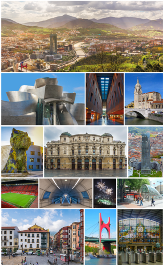
Bilbao is a city in northern Spain, the largest city in the province of Biscay and in the Basque Country as a whole. It is also the largest city proper in northern Spain. Bilbao is the tenth largest city in Spain, with a population of more than 347,000 as of 2023. The Bilbao metropolitan area has 1,037,847 inhabitants, making it the most populous metropolitan area in northern Spain; with a population of 875,552, the comarca of Greater Bilbao is the fifth-largest urban area in Spain. Bilbao is also the main urban area in what is defined as the Greater Basque region.

<span class="mw-page-title-main">Bilbao metro</span> Rapid transit system in Bilbao, Spain

The Bilbao metro is a rapid transit system serving the city of Bilbao and the region of Greater Bilbao. Lines 1 and 2 have a "Y" shape, as they transit both banks of the river Ibaizabal and then combine to form one line that ends in the south of Bilbao. Line 3 has a "V" shape connecting the municipality of Etxebarri with the Bilbao neighbourhood of Matiko; the apex of the "V" is Zazpikaleak/Casco Viejo station, where all three current lines meet. The metro is connected with the Bilbao tram, Bilboko Aldiriak, Euskotren Trena, Feve, Renfe long-distance trains, and Bilbao's bus station. All three lines use metre gauge.

<span class="mw-page-title-main">Abando</span> District in Basque Country, Spain

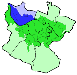
Abando, formerly known as San Vicente de Abando, is one of the eight districts of Bilbao, Basque Country (Spain). It covers most of the city's centre, located on the left bank of the estuary of Bilbao. It is the only district of Bilbao with all of its land completely urbanised. Abando was originally an elizate and also a municipality until 1876, when part of it was annexed to Bilbao, the rest of the elizate's municipal land was integrated into Bilbao in 1890. In 2016 the population was 50,903. Abando is the wealthiest district in Bilbao, with personal and family incomes being well above the citywide average.

<span class="mw-page-title-main">Bilbobus</span> Metropolitan bus services in Bilbao, Spain

Bilbobus is the name for metropolitan bus services in Bilbao.

<span class="mw-page-title-main">Zorrotzaurre</span>

Zorrotzaurre is an artificial island located within the Deusto district of Bilbao, Spain.

<span class="mw-page-title-main">Indautxu</span> Quarter in Basque Country, Spain

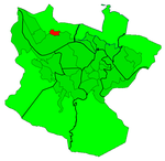
Indautxu is a quarter of central Bilbao, Basque Country (Spain), located in the district of Abando. It is a relatively affluent neighbourhood and is most famous for the large number of private hospitals and clinics, the large Society of Jesus school and the Doña Casilda Iturrizar park, all located in the area.

<span class="mw-page-title-main">Bilbao-Abando railway station</span> Railway station in Bilbao, Spain

The Abando Indalecio Prieto railway station, usually known simply as Bilbao-Abando and previously known as Estación del Norte is a terminal railway station in Bilbao, Basque Country (Spain). The name comes from Abando, the district in which the station is located, and Indalecio Prieto, who was Minister of Public Works during the Second Spanish Republic. The station serves as the terminus station for several long and medium distance services operated by Renfe as well as commuter rail services within the Bilbao metropolitan area operated by Cercanías. The station has direct access to Metro Bilbao and to the tram, as well as many local and regional bus lines. The railway station Bilbao-Concordia, operated by Renfe Feve is located in close proximity. After the construction of the high-speed line Basque Y is finished, Bilbao-Abando will serve as the western terminus, which will involve the creation of a completely new station replacing the current one.

<span class="mw-page-title-main">Bolueta (Bilbao metro)</span> Rapid transit station in Bilbao, Basque Country, Spain

Bolueta is a station on lines 1 and 2 of the Bilbao metro. The station is located in the neighborhood of the same name, in the district of Begoña. It opened on 5 July 1997.

<span class="mw-page-title-main">Zazpikaleak/Casco Viejo (Bilbao metro)</span> Metro station in Bilbao, Spain

Zazpikaleak/Casco ViejoZazpikaleak and Casco Viejo – is a railway station in Bilbao, Basque Country, Spain. It is located in the historical neighborhood of Casco Viejo, in the district of Ibaiondo. It links the Bilbao metro rapid transit services with the Euskotren Trena commuter rail network. It is the main railway hub for trips between the metropolitan underground network and the railway services to Eibar, Gernika, Bermeo and San Sebastián as well as the Txorierri valley. The original metro station opened on 11 November 1995, and on 8 April 2017 in its current form.

<span class="mw-page-title-main">Deustu (Bilbao metro)</span> Rapid transit station in Bilbao, Basque Country, Spain

Deustu is a station on lines 1 and 2 of the Bilbao metro. The station is located in the neighbourhood and district of the same name. It is located close to the Bidarte mall and Bilbao's Escuela Oficial de Idiomas. It opened on 11 November 1995.

<span class="mw-page-title-main">Sarriko (Bilbao metro)</span> Rapid transit station in Bilbao, Basque Country, Spain

Sarriko is a station on lines 1 and 2 of the Bilbao metro. The station is located in the neighbourhood of Ibarrekolanda, part of the Deusto district. It is named after the Sarriko park located nearby. The station is in close proximity to the Faculty of Business and Economic Sciences of the University of the Basque Country as well as the conservatory of music. It was opened on 11 November 1995.

<span class="mw-page-title-main">San Ignazio (Bilbao metro)</span> Rapid transit station in Bilbao, Basque Country, Spain

San Ignazio is a station on lines 1 and 2 of the Bilbao metro. It is located in the San Ignazio-Elorrieta neighbourhood, part of the Deusto district. The station is in close proximity to the San Ignazio Sports Center and the Elorrieta football field. It was opened on 11 November 1995.

<span class="mw-page-title-main">Bilbao tram</span> Tram system in the Basque Country, Spain

The Bilbao tram is a tram system in Bilbao, Basque Country, Spain. Operated by Euskotren under the brand Euskotren Tranbia, it comprises a single 7.8 km (4.8 mi) line, inaugurated on 18 December 2002 and last extended on 25 March 2022.

<span class="mw-page-title-main">Frank Gehry Bridge</span> Bridge

The Frank Gehry Bridge is a bridge in Bilbao that connects Deusto and Zorrotzaurre. Its name is a tribute to Canadian-born American architect Frank Gehry, author of the Guggenheim Museum Bilbao.

<span class="mw-page-title-main">Matiko (Bilbao metro)</span> Railway station in Bilbao, Basque Country, Spain

Matiko is the northern terminus of line 3 of the Bilbao metro. The station is also served by Euskotren Trena commuter and regional rail services. The station is located in the neighbourhood of Matiko-Ciudad Jardín, part of the Uribarri district of Bilbao. In its current form, the station opened on 8 April 2017.

<span class="mw-page-title-main">Abandoibarra</span>

Abandoibarra is an area of the city of Bilbao, Spain, located next to the estuary in the neighborhood of Abando. After the process of deindustrialization experienced by the town since the mid-1990s, Abandoibarra became the central axis of urban regeneration in the city, continuing today in Zorrotzaurre.

<span class="mw-page-title-main">City Hall Bridge</span> Bascule bridge in Bilbao, Spain

The City Hall Bridge, formerly known as the Begoña Bridge, is a bascule bridge on the estuary of Bilbao, connecting the districts of Gazteleku on the right and Abando on the left.

<span class="mw-page-title-main">Deusto Bridge</span> Bridge in Bilbao, Spain

The Deusto Bridge is a bascule bridge over the estuary of Bilbao. This bridge connects the districts of Abando and Deusto.

<span class="mw-page-title-main">Txorierri line</span> Railway in the Basque Country, Spain

The Txorierri line, also known as the Bilbao–Lezama railway is a narrow-gauge railway in Biscay, Basque Country, Spain. Owned by Euskal Trenbide Sarea, it runs from Lezama to Matiko, from where it continues as line 3 of the Bilbao metro.

References

  1. 1 2 "Deusto, the independent republic" (PDF). Periódico Bilbao. Bilbao: Bilbao Municipal Government. November 2007. Retrieved 31 May 2020.
  2. "Bilbao". Euskal Herria, la mirada mágica. Season 1. Episode 10 (in Spanish). EITB. ETB 2. Archived from the original on 2021-12-14. Retrieved 1 June 2020.
  3. Molano, E.; Vázquez, S. (8 October 2018). "Zorrozaurre ya es una isla". El Correo (in Spanish). Retrieved 8 October 2018.
  4. "Deustuko Unibertsitatea" [University of Deusto]. Auñamendi Entziklopedia (in Basque). Eusko Ikaskuntza. Retrieved 1 June 2020.
  5. "Fakultatearen historia" [History of the faculty]. University of the Basque Country (in Basque). Retrieved 1 June 2020.
  6. "El tranvía llegará al nuevo Zorrotzaurre a través del Puente Euskalduna" [The tramway will reach the new Zorrotzaurre through the Euskalduna Bridge]. El Correo (in Spanish). Bilbao. 6 October 2007. Retrieved 1 June 2020.
  7. Alonso, Alberto G. (24 January 2004). "El Puerto abandonó ayer el Canal de Deusto tras 38 años de actividad comercial" [The Port left the Deusto Canal yesterday after 38 years of commercial activity]. Deia (in Spanish). Bilbao. Archived from the original on 2009-01-24. Retrieved 1 June 2020.
  8. Molano, Eva (19 March 2018). "Una flota de gánguiles trasladará desde esta semana tierra del canal de Duesto" [A fleet of hoppers will move land from the Deusto Canal]. El Correo (in Spanish). Bilbao. Retrieved 1 June 2020.
  9. Molano, Eva (8 October 2018). "Zorrotzaurre ya es una isla" [Zorrotzaurre is now an island]. El Correo (in Spanish). Bilbao. Retrieved 1 June 2020.
  10. García, A. (22 November 2008). "El puente de Deusto afronta su primera reforma integral tras 70 años de servicio" [The Deusto Bridge faces its first complete renovation after 70 years of service]. Deia (in Spanish). Bilbao. Archived from the original on 2008-11-22. Retrieved 1 June 2020.
  11. Alonso, Alberto G. (29 January 2020). "Un nombre femenino bautizará el nuevo puente de la isla" [The new bridge of the island to have a female name]. Deia (in Spanish). Bilbao. Retrieved 1 June 2020.

43°16′20″N2°56′45″W / 43.27222°N 2.94583°W / 43.27222; -2.94583