Bilbao is a city in northern Spain, the largest city in the province of Biscay and in the Basque Country as a whole. It is also the largest city proper in northern Spain. Bilbao is the tenth largest city in Spain, with a population of 345,141 as of 2015. The Bilbao metropolitan area has 1,037,847 inhabitants, making it one of the most populous metropolitan areas in northern Spain; with a population of 875,552 the comarca of Greater Bilbao is the fifth-largest urban area in Spain. Bilbao is also the main urban area in what is defined as the Greater Basque region.

Basauri is a major municipality of Biscay, in the Basque Country, an Autonomous Community in northern Spain.

Areeta is a neighbourhood of Getxo. It is an affluent residential area that was built over the sands of a beach where the Gobela Creek died into a diffuse delta at the mouth of the Estuary of Bilbao in the early 20th century.
Begoña or more puristically but also more rarely spelled Begoina, meaning 'the lower foot', is a historical municipality of Biscay which was incorporated into Bilbao in 1925.

Santutxu is a neighbourhood of the Spanish city of Bilbao. It belongs to the 4th urban district, named Begoña. It is a popular residential neighbourhood which has a significant number of small businesses and has received some waves of immigration in the last years, particularly Romanians. The Begoña district consists of three neighbourhoods: Santutxu, Begoña and Bolueta.

Bilbao La Vieja in Spanish, "Old Bilbao" in English and Bilbo Zaharra in Basque.
San Francisco is a neighbourhood of Bilbao, in the Basque Country, and also one of the most run down areas. In the last decades, it has absorbed much of the immigration received by the city and has been integrated into the Ibaiondo district.

Abando, formerly known as San Vicente de Abando, is one of the eight districts of Bilbao, Basque Country (Spain). It covers most of the city's centre, located on the left bank of the estuary of Bilbao. It is the only district of Bilbao with all of its land completely urbanised. Abando was originally an elizate and also a municipality until 1876, when part of it was annexed to Bilbao, the rest of the elizate's municipal land was integrated into Bilbao in 1890. In 2016 the population was 50,903. Abando is the wealthiest district in Bilbao, with personal and family incomes being well above the citywide average.

Bilbobus is the name for metropolitan bus services in Bilbao.
Indautxu is a quarter of central Bilbao, Basque Country (Spain), located in the district of Abando. It is a relatively affluent neighbourhood and is most famous for the large number of private hospitals and clinics, the large Society of Jesus school and the Doña Casilda Iturrizar park, all located in the area.
Las Siete Calles or Casco Viejo in Spanish or Zazpikaleak or Alde Zaharra in Basque are different names for the medieval neighbourhood of Bilbao, part of the Ibaiondo district. The names mean Seven Streets or Old Town respectively and it used to be the walled part of the town until the end of the 19th century.

Ibaiondo is the fifth district of the city of Bilbao (Biscay), in the Spanish Basque Country. Ibaiondo is a recently used name that means 'beside the river' in Basque. It is divided into the neighbourhoods of Atxuri, Bilbo Zarra, Casco Viejo, Iturralde, Abusu, San Adrián, San Francisco, Solokoetxe, Miribilla and Zabala.

Basurto-Zorroza is the eighth district of the city of Bilbao (Biscay), in the Spanish Basque Country. It is divided into the neighbourhoods of Altamira, Basurto, Olabeaga, Masustegui-Monte Caramelo and Zorrotza. It is separated from Barakaldo by the river Kadagua. Its area is 7.09 square kilometers and has a population of 31,672 inhabitants.

Uribarri is the second district of the city of Bilbao (Biscay), in the Spanish Basque Country. It is divided into the neighbourhoods of Castaños, Matico-Ciudad Jardín, Uríbarri proper and Zurbaran-Arabella.

Bolueta is a station of line 1 and line 2 of Metro Bilbao. The station is located in the neighbourhood of the same name, in the district of Begoña. It opened in 1997.

Zazpikaleak/Casco Viejo is a railway station in Bilbao, Basque Country, Spain. It is located in the historical neighborhood of Casco Viejo, in the district of Ibaiondo. It links the Bilbao metro rapid transit services with the Euskotren Trena commuter rail network. It is the main railway hub for trips between the metropolitan underground network and the railway services to Eibar, Gernika, Bermeo and San Sebastián as well as the Txorierri valley. The original metro station opened on 11 November 1995, and on 8 April 2017 in its current form.

Sarriko is a station of line 1 and line 2 of Metro Bilbao. The station is located in the neighbourhood of Ibarrekolanda, part of the Deustu district. It is named after the Sarriko park located nearby. The station is in close proximity to the Faculty of Business and Economic Sciences of the University of the Basque Country as well as the Conservatory of music. It was opened on 11 November, 1995.

Mount Cobetas is a mountain in the city of Bilbao, Spain. It is located southwest from the city center and stands 205 m (673 ft) high. It raises between the neighborhoods of Altamira and Zorroza, both located in the district Basurto-Zorroza. It was refurbished in 2005 and became the largest park of the city, with an area of 18.5 ha. On the top stands the ruins of the Altamira Fort, used during the Spanish Civil War.

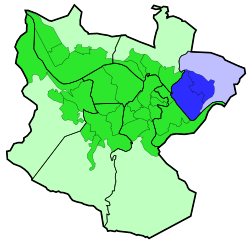
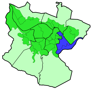
Line 3 of the Bilbao metro is a rapid transit line in Biscay, Basque Country, Spain. It is 5.9 km (3.7 mi) long and connects Etxebarri and the Uribarri and Otxarkoaga-Txurdinaga districts in Bilbao with the city center.

Matiko is the northern terminus of line 3 of the Bilbao metro. The station is also served by Euskotren Trena commuter and regional rail services. The station is located in the neighborhood of Matiko-Ciudad Jardín, part of the Uribarri district of Bilbao. In its current form, the station opened on 8 April 2017.
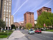 Gabriel Aresti avenue in Txurdinaga.