Ibaiondo

Last updated
Ibaiondo
District

Ibaiondo.svg

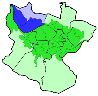
Ibaiondo district is highlighted in blue in this map of the districts of Bilbao.
Country Spain
Autonomous community Basque Country
Province Biscay
Comarca Greater Bilbao
Municipality Bilbao
Area
  District 9.65 km2 (3.73 sq mi)
  Urban 2.45 km2 (0.95 sq mi)
Population (2016)
  District 61,184
  Density 6,300/km2 (16,000/sq mi)

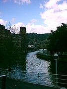
Ibaiondo is the fifth district of the city of Bilbao (Biscay), in the Spanish Basque Country. Ibaiondo is a recently used name that means 'beside the river' in Basque. It is divided into the neighbourhoods of Atxuri, Bilbo Zarra, Casco Viejo, Iturralde, Abusu, San Adrián, San Francisco, Solokoetxe, Miribilla and Zabala. [1]

Bilbao Municipality in Basque Country, Spain

Bilbao is a city in northern Spain, the largest city in the province of Biscay and in the Basque Country as a whole. It is also the largest city proper in northern Spain. Bilbao is the tenth largest city in Spain, with a population of 345,141 as of 2015. The Bilbao metropolitan area has roughly 1 million inhabitants, making it one of the most populous metropolitan areas in northern Spain; with a population of 875,552 the comarca of Greater Bilbao is the fifth-largest urban area in Spain. Bilbao is also the main urban area in what is defined as the Greater Basque region.

Biscay Province of Spain

Biscay is a province of Spain located just south of the Bay of Biscay. The name also refers to a historical territory of the Basque Country, heir of the ancient Lordship of Biscay. Its capital city is Bilbao. It is one of the most prosperous and important provinces of Spain as a result of the massive industrialization in the last years of the 19th century and first half of the 20th century. Since the deep deindustrialization of the 1970s, the economy has come to rely more on the services sector.

Spain Kingdom in Southwest Europe

Spain, officially the Kingdom of Spain, is a country mostly located in Europe. Its continental European territory is situated on the Iberian Peninsula. Its territory also includes two archipelagoes: the Canary Islands off the coast of Africa, and the Balearic Islands in the Mediterranean Sea. The African enclaves of Ceuta, Melilla, and Peñón de Vélez de la Gomera make Spain the only European country to have a physical border with an African country (Morocco). Several small islands in the Alboran Sea are also part of Spanish territory. The country's mainland is bordered to the south and east by the Mediterranean Sea except for a small land boundary with Gibraltar; to the north and northeast by France, Andorra, and the Bay of Biscay; and to the west and northwest by Portugal and the Atlantic Ocean.

Contents

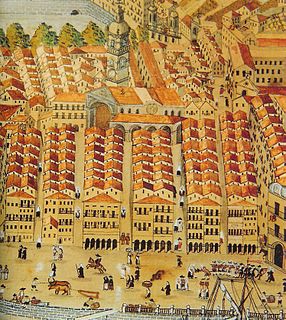
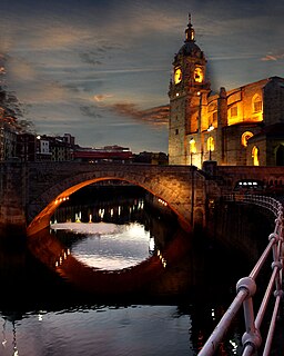
The original walled city, the Casco Viejo, is located in this district, including the oldest buildings of the city like the Santiago Cathedral and Saint Anton Church, both from the 15th century.

Bilbao Cathedral cultural property in Bilbao, Spain

Santiago Cathedral is a Roman Catholic church in the city of Bilbao. The temple was originally built during the 14th-15th centuries as Bilbao's main parish church, and was only declared cathedral in 1950 when the Roman Catholic Diocese of Bilbao was officially created. Its origins probably date to well before the foundation of the city in 1300, when Bilbao was little more than a small enclave of fishermen.

Today the modern district includes both the oldest and the newest neighbourhood, Miribilla, which was started in 1999 and completed two years after. [2]

It is the most extensive district of Bilbao, with an area of 9.65 km² (25% of the municipality) but the urban area has an area of only 2.45 km², the rest of the district is part of mount Pagasarri. It is also the city's most populated district, with 61,184 inhabitants in 2016.

Urban area Human settlement with high population density and infrastructure of built environment

An urban area or urban agglomeration is a human settlement with high population density and infrastructure of built environment. Urban areas are created through urbanization and are categorized by urban morphology as cities, towns, conurbations or suburbs. In urbanism, the term contrasts to rural areas such as villages and hamlets and in urban sociology or urban anthropology it contrasts with natural environment. The creation of early predecessors of urban areas during the urban revolution led to the creation of human civilization with modern urban planning, which along with other human activities such as exploitation of natural resources leads to human impact on the environment.

Pagasarri is one of the two small mountain ranges that encloses the city of Bilbao, Basque Country, Spain and is part of the Basque Mountains. Its main peak separates the municipality of Bilbao from Arrigorriaga and Alonsotegi, and has an elevation of 673 m. It is part of a wider massif called Ganekogorta.

Sights

The Estuary of Bilbao in Ibaiondo. Riabilbao.jpg
The Estuary of Bilbao in Ibaiondo.
The Estuary of Bilbao in Ibaiondo. 

Related Research Articles

Euskotren Trena train operating company

Euskotren Trena, formerly known just as Euskotren is a commuter, inter-city and urban transit train-operating company that operates local and inter-city passenger services in the provinces of Biscay and Gipuzkoa, in the Basque Country, Spain. It is one of the four commercial brands under which Basque Railways operates, as a public company managed by the Basque government. The entire 181.1-kilometre (112.5 mi) network uses 1,000 mm narrow gauge rail tracks which have been owned by the Basque Government since their transferral from the Spanish government; the rail tracks and stations were part of the FEVE network until its transferral. Euskotren Trena also operates the Donostia/San Sebastián metro under the brand Metro Donostialdea.

Metro Bilbao rapid transit system in Bilbao, Spain

Metro Bilbao is a rapid transit (metro) system serving the city of Bilbao and the region of Greater Bilbao. Lines 1 and 2 have a "Y" shape, as they transit both banks of the Nervión river and then combine to form one line that ends in the south of Bilbao. Line 3 has a "V" shape connecting the municipality of Etxebarri with the Bilbao neighbourhood of Matiko; the corner of the "V" is Zazpikaleak/Casco Viejo station, where all three current lines meet. The network of Metro Bilbao is connected with Euskotren Tranbia, Bilboko Aldiriak, Euskotren Trena, Feve, the Renfe service and Bilbao's bus station Termibus. It uses a meter gauge.

Getxo Municipality in Basque Country, Spain

Getxo is a town located in the province of Biscay, in the autonomous community of the Basque Country, in Spain. It is part of Greater Bilbao, and has about 80,000 inhabitants (2014). Getxo is mostly an affluent residential area, as well as being the third largest municipality of Biscay.

Deusto District in Basque Country, Spain

Deusto is a district of the city of Bilbao (Biscay), in the Spanish Basque Country on the right bank of the Estuary of Bilbao. It includes the neighbourhoods of Arangoiti, Ibarrekolanda, San Ignacio-Elorrieta and San Pedro de Deusto-La Rivera, with a total population of 48,933. It used to be a separate municipality until it was incorporated in 1925. The traditional center has always been at the Church of St. Peter. The neighbourhood is linked to downtown Bilbao by a bascule bridge.

Santutxu Santutxu in Basque Country, Spain

Santutxu is a neighbourhood in Bilbao that belongs to the 4th urban district, named Begoña. It is a popular residential neighbourhood which has a significant number of small businesses and has received some waves of immigration in the last years, particularly Romanians .The Begoña district consists of three neighbourhoods: Santutxu, Begoña and Bolueta.

Bilbao la Vieja neighborhood

Bilbao La Vieja in Spanish, "Old Bilbao" in English and Bilbo Zaharra in Basque.

San Francisco is an important neighbourhood of Bilbao, in the Basque Country, and also one of the most run down areas. In the last decades, it has absorbed much of the immigration received by the city and has been integrated into the Ibaiondo district.

Abando District in Basque Country, Spain

Abando, formerly known as San Vicente de Abando, is one of the eight districts of Bilbao, Basque Country (Spain). It covers most of the city's centre, located on the left bank of the estuary of Bilbao. It is the only district of Bilbao with all of its land completely urbanised. Abando was originally an elizate and also a municipality until 1876, when part of it was annexed to Bilbao, the rest of the elizate's municipal land was integrated into Bilbao in 1890. In 2016 the population was 50,903.

Bilbobus

Bilbobus is the name for metropolitan bus services in Bilbao.

Casco Viejo cultural property in Bilbao, Spain

Las Siete Calles or Casco Viejo in Spanish or Zazpikaleak or Alde Zaharra in Basque are different names for the medieval neighbourhood of Bilbao, part of the Ibaiondo district. The names mean Seven Streets or Old Town respectively and it used to be the walled part of the town until the end of the 19th century.

Bilbao-Abando railway station metro station in Bilbao, Spain

The Abando Indalecio Prieto railway station also known simply as Bilbao-Abando and previously known as Estación del Norte is a terminal railway station in Bilbao, Basque Country (Spain). The name comes from Abando, the district in which the station is located, and Indalecio Prieto, who was Minister of Public Works during the Second Spanish Republic. The station serves as the terminus station for several long and medium distance services operated by Renfe as well as commuter rail services within the Bilbao metropolitan area operated by Cercanías. The station has direct access to Metro Bilbao and to Bilbao's Tram, as well as many local and regional bus lines. The railway station Bilbao-Concordia, operated by Renfe Feve is located in close proximity. After the construction of the high-speed line Basque Y is finished, Bilbao-Abando will serve as the western terminus, which will involve the creation of a completely new station replacing the current one.

Otxarkoaga-Txurdinaga District in Basque Country, Spain

Otxarkoaga-Txurdinaga is the third district of the city of Bilbao (Biscay), in the Spanish Basque Country. It is divided into the neighbourhoods of Otxarkoaga and Txurdinaga. It has an area of 389.94 hectares and a population of 26,458 inhabitants (2016), being one of the least densely populated districts of the city.

Basurto-Zorroza District in Basque Country, Spain

Basurto-Zorroza is the eighth district of the city of Bilbao (Biscay), in the Spanish Basque Country. It is divided into the neighbourhoods of Altamira, Basurto, Olabeaga, Masustegui-Monte Caramelo and Zorrotza. It is separated from Barakaldo by the river Kadagua. Its area is 7.09 square kilometers and has a population of 31,672 inhabitants.

Bilbao-Atxuri station

Bilbao-Atxuri is a terminal railway station in Bilbao, Basque Country (Spain). It serves as the terminus station for the commuter rail trains of Euskotren Trena lines 1D and E4. It is also the southern terminus of Bilbao's Tramway operated by Euskotren Tranbia. The station is located in the neighbourhood of Atxuri, part of the Ibaiondo district, in Bilbao. The station also serves as headquarters for the Basque Railways. It opened in 1912.

Bolueta (Metro Bilbao) station of Metro Bilbao

Bolueta is a railway station in Bilbao, Basque Country. It serves as a station for the line 1 and line 2 of Metro Bilbao. It connects the underground railway with the commuter trains of Euskotren Trena lines 1D and E4. The station is located in the neighbourhood of Bolueta in the district of Begoña in Bilbao. It was opened in 1997.

Zazpikaleak/Casco Viejo station metro station in Bilbao, Spain

Zazpikaleak/Casco Viejo is a railway station in Bilbao, Basque Country (Spain). It is located in the historical neighbourhood of Casco Viejo, in the district of Ibaiondo. It connects the rapid transit network of Metro Bilbao with the commuter rail services of Euskotren Trena. It is the main hub of railway connection between the metropolitan underground network and the railway services to Eibar and San Sebastián as well as the Txorierri valley. In its current form, the station opened on 8 April 2017.

San Antón Bridge bridge in Spain

The San Antón Bridge is an arch bridge in Bilbao, Spain. It spans the Estuary of Bilbao, linking the neighborhoods of Bilbao La Vieja and Casco Viejo. It is the oldest bridge in the city, with the original bridge being opened before 1318. At the time of its opening, and during centuries, it was the only bridge that crossed the river. It is located next to the Church of San Antón.

Arenal Bridge bridge in Spain

The Arenal Bridge is a reinforced concrete bridge in Bilbao, Spain.

Mercado de la Ribera

The Mercado de la Ribera is a market square in Bilbao, the capital of the Basque Province of Viscay in the north of Spain. It is on the right bank of the Nervion River, next to Casco Viejo. Its built area of 10,000 square metres (110,000 sq ft) makes it the biggest covered market in Europe. Inside it, there are stalls that sell different products, mostly fresh produce. There are fish markets, butchers and green grocers. There is also a part of the market for the local farmers' products.

References

Coordinates: 43°15′25″N2°55′24″W / 43.2569°N 2.92333°W / 43.2569; -2.92333

Geographic coordinate system Coordinate system

A geographic coordinate system is a coordinate system that enables every location on Earth to be specified by a set of numbers, letters or symbols. The coordinates are often chosen such that one of the numbers represents a vertical position and two or three of the numbers represent a horizontal position; alternatively, a geographic position may be expressed in a combined three-dimensional Cartesian vector. A common choice of coordinates is latitude, longitude and elevation. To specify a location on a plane requires a map projection.