
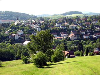
Bayerisch Eisenstein, until 1951 just Eisenstein is a village and a municipality in the Regen district, in Bavaria, Germany.

Roßtal is a market town in the district of Fürth, Bavaria, Germany. As of 2020 it had a population of 10,127.

Waldkirchen is the biggest town in the district of Freyung-Grafenau in Germany.

Freyung is a town in Bavaria, Germany, capital of the Freyung-Grafenau district. It is situated in the Bavarian Forest mountain range, near the border with Austria and the Czech Republic.
Grafenau is a town in the Freyung-Grafenau district, in Bavaria, Germany. 32 km north of Passau, the town is situated in the Bavarian Forest and is the base of the Bavarian Forest National Park Authority. Grafenau is a holiday destination with a variety of kinds of accommodation from self-catering apartments to a "holiday village".

Wassertrüdingen is a town in the district of Ansbach, Middle Franconia, Bavaria, Germany. It is between the Hesselberg, the only Franconian mountain with a view on the Alps, the wooded heights of the Oettinger Forest and the foothills of the Hahnenkamm. The Fränkisches Seenland recreation area is 15 kilometers away. Altentrüdingen, Fürnheim, Geilsheim, Obermögersheim, Reichenbach und Schobdach are part of Wassertrüdingen

Schwarzenbach am Wald is a town in the district of Hof, in Bavaria, Germany. It is situated 21 km west of Hof, and 23 km northeast of Kulmbach.

Thannhausen is a town in the district of Günzburg, in Bavaria, Germany. It is situated on the river Mindel, 24 kilometres (15 mi) southeast of Günzburg, and 33 kilometres (21 mi) west of Augsburg.

Colmberg is a municipality in the district of Ansbach in Bavaria in Germany. Colmberg is the site of Colmberg Castle, built in the 13th century and purchased in 1318 by Duke Frederick IV of Nuremberg. The town is located in Nature Park Frankenhöhe.
Grub am Forst is a municipality in the district of Coburg in Bavaria in Germany. It has ca 3,100 residents. The nearest large town is Coburg. The following villages are part of it:

Lalling is a municipality in the Lower Bavarian district of Deggendorf in Germany. It is a nationally recognized resort town.

Philippsreut is a municipality in the district of Freyung-Grafenau in Bavaria, Germany. It lies on the border with the Czech Republic.
Spiegelau is a municipality in the district of Freyung-Grafenau in Bavaria in Germany. It lies in the heart of the Bavarian Forest.
Grafengehaig is a municipality in the district of Kulmbach in Bavaria in Germany.

Münchsmünster is a municipality in the district of Pfaffenhofen in Bavaria in Germany. The town grew up around the former Münchsmünster Abbey, which was demolished around 1817 and its stones used for construction of houses.

Drachselsried is a municipality in the district of Regen, in Bavaria, Germany. Drachselsried is in the Zeller Valley, and is part of the Glass Road (Glasstrasse) The area is part of the Bavarian Forest National Park. The village is a small, highly organised, friendly place to live. Bayern Eins, the German radio station, gave some history details of the village, which was first noted in 1184. The village continues to grow with the addition in 2017 of a retirement home with private apartments, close to the village centre. A number of new homes have been built on land available for purchase from the local council.

Beratzhausen is a market town and municipality in the district of Regensburg in Bavaria in Germany.

Mitterfels is a municipality in the district of Straubing-Bogen in Bavaria, Germany. It is the head of the Verwaltungsgemeinschaft Mitterfels.

Lindberg is a municipality in the district of Regen in Bavaria in Germany in the immediate neighbourhood of the larger town Zwiesel.

Tittling is a municipality in the district of Passau in Bavaria in Germany.


