Rimbach, Upper Palatinate

Last updated
Rimbach (Upper Palatinate)
DEU Rimbach Oberpfalz COA.svg
Location of Rimbach (Upper Palatinate) within Cham district
Rimbach in CHA.svgLamRimbachTiefenbachChamSchorndorfRodingReichenbachRettenbachFalkensteinZellWald
Germany adm location map.svg
Red pog.svg
Rimbach (Upper Palatinate)
Bavaria location map.svg
Red pog.svg
Rimbach (Upper Palatinate)
Coordinates: 49°13′51″N12°52′46″E / 49.23083°N 12.87944°E / 49.23083; 12.87944
Country Germany
State Bavaria
Admin. region Oberpfalz
District Cham
Government
   Mayor (202026) Heinz Niedermayer [1] (CSU)
Area
  Total24.69 km2 (9.53 sq mi)
Elevation
488 m (1,601 ft)
Population
 (2022-12-31) [2]
  Total1,832
  Density74/km2 (190/sq mi)
Time zone UTC+01:00 (CET)
  Summer (DST) UTC+02:00 (CEST)
Postal codes
93485
Dialling codes 0 99 41
Vehicle registration CHA
Website www.gemeinde-rimbach.de

Rimbach is a municipality in the district of Cham (district) in the Upper Palatinate in Bavaria in Germany.

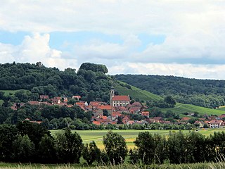
Rimbach is a village at the foot of the Hoher Bogen (a seven-peaked mountain ridge in the Northern Bavarian Forest National Park). In the village is the Baroque 'Church of Saint Michael' built in 1719. The church had a major expansion in 1970 but preserved the Baroque carvings on the main altar and side altars. Within the church grounds is the ‘Old Church’, built in 1438 with its carvings and altars. And is still used for small services (it seats about 36 individuals).

This village holds on to the traditional customs and culture of the Bavarian Forest Area. There are many organized groups that maintain the native dress, dancing, songs, and the traditional musical instruments from the area. Every Fall there is a “High Garden Fest”(not a ‘beer tent’ or Om-Pa-Pa Fest) to celebrate these cultural treasures of music and song.

There are numerous hiking trails within this area of the National Forest. One hike is to the castle-ruin property of the Earls Preysing, arena of the Erzählung. This area was the inspiration of “The Maiden of Lichtenegg" by the forest poet Maximilian Schmidt. This castle-ruin was used as a watchtower to protect the area from the advancing Swedes during the 16th century. In late July, an outdoor, annual 'Folk Play' is held at outdoor stage area next to the Ruin that tells the story of "The Maiden of Lichtenegg".

Two other hikes to the top of the mountain are to the antenna area for German TV broadcasting at the peak called Burgstall. This relay station brought broadcast TV to a remote area of German and provided news and educational content to Western Bohemia over the "Iron Curtain" during the Cold War. From this location, one can hike to the other end of the mountain ridge to the peak named Eckstein. It also has a Cold War history, since it was the site of German, French and American Signal Intelligence operations (since closed in the 1990s) that were directed over the Czech Border (3.5 miles to the East). [3]

Related Research Articles

Gotha is a Kreis (district) in western central Thuringia, Germany. Neighboring districts are Unstrut-Hainich-Kreis, Sömmerda, the Kreis-free city Erfurt, Ilm-Kreis, Schmalkalden-Meiningen and the Wartburgkreis.

<span class="mw-page-title-main">Sonthofen</span> Town in Bavaria, Germany

Sonthofen is the southernmost town of Germany, located in the Oberallgäu region of the Bavarian Alps. Neighbouring Oberstdorf is situated 14 km farther south but is not classified as a town. In 2005, Sonthofen was awarded "Alpenstadt des Jahres". The town has 21,300 inhabitants.

<span class="mw-page-title-main">Stamsried</span> Municipality in Bavaria, Germany

Stamsried is a village and municipality in the district of Cham in the Upper Palatinate region of Bavaria, Germany, near the Czech border. It is also located in the Roman Catholic diocese of Regensburg. Stamsried has a population of 2,319 as of June 2004 and an area of 4,343 hectares which includes surrounding countryside outside the built up area of the village itself, the population density is 53.4 persons per square kilometer. Stamsried is located 456 meters above sea level and contains rolling hills as high as 600 meters.

<span class="mw-page-title-main">Regen</span> Town in Bavaria, Germany

Regen is a town in Bavaria, Germany, and the district town of the district of Regen.

<span class="mw-page-title-main">Landau an der Isar</span> Town in Bavaria, Germany

Landau an der Isar is the second-largest town in the Lower Bavarian district, or Landkreis, of Dingolfing-Landau, in the state of Bavaria, Germany. It lies on the river Isar, 120 km downstream from Munich. In 2020, its population was around 14,000.

<span class="mw-page-title-main">Schliersee</span> Municipality in Bavaria, Germany

Schliersee is a small town (Markt) and a municipality in the district of Miesbach in Bavaria in Germany. It is named after the nearby Lake Schliersee. It comprises the districts Schliersee (town), Westenhofen, Neuhaus, Fischhausen, Josefsthal and Spitzingsee.

<span class="mw-page-title-main">Mering</span> Municipality in Bavaria, Germany

Mering is a municipality in the district Aichach-Friedberg, in Bavaria, Germany. It is located on the river Paar.

<span class="mw-page-title-main">Freyung, Bavaria</span> Town in Bavaria, Germany

Freyung is a town in Bavaria, Germany, capital of the Freyung-Grafenau district. It is situated in the Bavarian Forest mountain range, near the border with Austria and the Czech Republic.

<span class="mw-page-title-main">Lenggries</span> Municipality in Bavaria, Germany

Lenggries is a municipality and a town in Bavaria, Germany. It is the center of the Isarwinkel, the region along the Isar between Bad Tölz and Wallgau. The town has about 9,500 inhabitants. By area, it is the largest rural municipality ("Gemeinde") in what was formerly West Germany, and the 7th-largest overall.

<span class="mw-page-title-main">Fichtelberg, Bavaria</span> Municipality in Bavaria, Germany

Fichtelberg is a municipality in the district of Bayreuth in Bavaria in Germany. It is a state-recognised climatic spa.

<span class="mw-page-title-main">Heroldsberg</span> Municipality in Bavaria, Germany

Heroldsberg is a municipality in the district of Erlangen-Höchstadt, in Bavaria, Germany. It is located eleven kilometers north-east from the city of Nuremberg and 23 kilometers east from Erlangen and is the headquarters of Schwan-Stabilo.

<span class="mw-page-title-main">Castell, Bavaria</span> Municipality in Bavaria, Germany

Castell is a municipality in the district of Kitzingen in Bavaria in Germany. It was the seat of the Counts of Castell. Today it is part of the municipal association Wiesentheid. It has around 800 inhabitants.

<span class="mw-page-title-main">Dießen am Ammersee</span> Municipality in Bavaria, Germany

Dießen am Ammersee is a municipality in the district of Landsberg in Bavaria in Germany. It is located on the shores of the Ammersee.

<span class="mw-page-title-main">Weitnau</span> Municipality in Bavaria, Germany

Weitnau is a municipality in the rural district Oberallgäu in Bavaria/Germany. Together with the neighboring municipality of Missen-Wilhams, Weitnau shares an administrative unit.

<span class="mw-page-title-main">Sinzing</span> Municipality in Bavaria, Germany

Sinzing is a municipality in the district of Regensburg in Bavaria in Germany.

<span class="mw-page-title-main">Bad Feilnbach</span> Municipality in Bavaria, Germany

Bad Feilnbach is a municipality in the Upper Bavarian district of Rosenheim at the foot of Wendelstein Mountain in Germany. As a famous 'Moorheilbad' the municipality was awarded in 1973 the title "Bad". Since the 19th century the peat deposits were the basis for a continued expansion of the spa and health facilities. The recognized healing success of "black gold" on a variety of diseases were the basis for the development of a well-known spa and tourist community. Due to its wooded surroundings and the mild climate Feilnbach is called the "Bavarian Meran". The entire municipality is recognized as a healing spa resort except for parts of the former municipality Dettendorf.

<span class="mw-page-title-main">Weichs</span> Municipality in Bavaria, Germany

Weichs is a municipality in the district of Dachau in Bavaria in Germany. There are four main villages in the municipality: Weichs, Aufhausen, Ebersbach, and Fränking. In addition, there are several smaller villages: Albertshof, Biechlhof, Breitenwiesen, Daxberg, Edenholzhausen, Edenpfaffenhofen, Erlbach, Erlhausen, Hölzböck, Jedenhofen, and Zillhofen.

<span class="mw-page-title-main">Untergriesbach</span> Municipality in Bavaria, Germany

Untergriesbach is a municipality in the district of Passau in Bavaria in Germany.

<span class="mw-page-title-main">Neukirchen, Lower Bavaria</span> Municipality in Bavaria, Germany

Neukirchen is a municipality in the district of Straubing-Bogen in Bavaria, Germany. It is located in the Donau-Wald region in the Bavarian Forest.

The village of Mittbach is a south-western part of the market town of Isen in the Upper Bavarian district of Erding, Germany. Until the district reform, which came into force on 1 July 1972, the municipality of Mittbach belonged to the district of Wasserburg am Inn. Since then it has belonged to the district of Erding until its dissolution in 1978.

References

  1. Liste der ersten Bürgermeister/Oberbürgermeister in kreisangehörigen Gemeinden, Bayerisches Landesamt für Statistik, 15 July 2021.
  2. Genesis Online-Datenbank des Bayerischen Landesamtes für Statistik Tabelle 12411-003r Fortschreibung des Bevölkerungsstandes: Gemeinden, Stichtag (Einwohnerzahlen auf Grundlage des Zensus 2011)
  3. (A few references above were taken from the "Bayerischer Wald" 'Bertelsmann Reiseführer' [Bavarian Forest Bertelsmann Tour Guide] c 1973)