Eugene Mall

Last updated
Eugene Mall
Eugene Mall
Location Eugene, Oregon, United States
Coordinates 44°02′56″N123°05′34″W / 44.048817°N 123.092753°W / 44.048817; -123.092753 Coordinates: 44°02′56″N123°05′34″W / 44.048817°N 123.092753°W / 44.048817; -123.092753
Opening dateFebruary 13, 1971
Closing dateSeptember 18, 2001
ManagementPublic space: Eugene Public Works; Eugene Downtown Association; Eugene Downtown Commission; Privately owned retail and office space
OwnerPublic space: Eugene, Oregon
ArchitectMitchell, McArthur, Garner, O'Kane Associates
ParkingInitially metered, then 2200 free spaces

The Eugene Mall was a car-free zone in the heart of Eugene, Oregon, United States, designed to encourage pedestrian access to shopping and entertainment areas. Dedicated on February 13, 1971, the mall opened amid three days of fanfare and dreams of a revitalized downtown. [1] [2] Conflict over the scope and use of the mall began immediately and continued for 30 years until the last remaining parts of the mall were opened to automobile traffic. At that time, a former Eugene mayor commented that the city's dreams for a bright future just hadn't worked. [3] Many residents, however, shared the much-earlier view of a former downtown merchant, that Eugene had sustained more damage from the mall than it would have from a natural disaster. [4]

Contents

History

Eugene Mall construction in 1970. The view is from 10th Avenue looking north down Willamette Street. Image courtesy of the Lane County Historical Museum Eugene Mall Construction.jpg
Eugene Mall construction in 1970. The view is from 10th Avenue looking north down Willamette Street. Image courtesy of the Lane County Historical Museum

The Post–World War II economic expansion created a gradual exodus from city core areas in the United States, and federally funded urban renewal projects empowered communities to demolish historic downtown areas and build new, modern structures. With dramatic increases in automobile purchases accompanied by a post-WWII decline in public transportation, many communities accepted urban renewal financing to demolish buildings and install much-needed parking areas. [4] [5]

As climate-controlled, suburban shopping centers became common in the 1960s, communities began to explore ways of drawing retail and entertainment business back into downtown areas. An experimental method of encouraging business was a downtown mall. One researcher found that approximately 200 pedestrian malls were constructed in the United States by the close of the 20th century, although only 15 remained in 2013. [6]

An Early prediction of the Eugene Mall

In 1963, a Lane County planning director predicted that by 1980, residents of Eugene would live in an age of push-button automation where hands-free cars would speed them into the city core, and they could park in multi-story structures and be whisked on moving sidewalks to an extensive, plastic-covered shoppers' mall. [7]

But the idea of the Eugene Mall had been considered by civic leaders prior to the 1960s. In 1945, for example, Fred Cuthbert proposed closing Willamette Street to cars in order to create a landscaped pedestrian oasis in the center of town, and he suggested parking along the perimeter. As part of the Eugene Centennial Celebration in 1959, a section of Broadway from Oak Street to Charnelton Street was closed to motor traffic, and pedestrians were delighted. [8]

By 1968 the city council was discussing a federally funded urban renewal project to build the Eugene Mall. [9]

University of Oregon east campus

Community leaders in 1961 had responded to demands for more student housing at the University of Oregon with a project known as the East Campus Urban Renewal. The project demolished historic homes east of the university and constructed large residence complexes surrounded by a landscaped campus that opened in 1965. Some reasoned that if a mall environment could work on a college campus, it would surely work in the downtown business district. [10]

Valley River Center

Discussions about the need for a downtown mall intensified when Valley River Center (VRC) opened in 1969. The new shopping center was a modern, climate controlled environment with anchor stores and upscale retail and food outlets. And the VRC offered 4000 free parking spaces.

Eugene inventoried its downtown holdings and found four major department stores, 170 to 200 retail outlets, and an estimated 500 firms including banks and professional offices. Most of the 3000 public parking spaces were metered. [11]

Groundbreaking for the Eugene Mall

Civic leaders determined that the time for a downtown mall had arrived, and construction began May 2, 1970, almost exactly nine months after the opening of Valley River Center. [12]

Geography and amenities

The mall's north–south axis extended on Willamette Street from roughly Eighth Avenue to Eleventh Avenue, with automobile traffic crossing the mall at Tenth Avenue. City bus traffic parked along Tenth Avenue, creating a downtown transfer station. Broadway, a street named in lieu of Ninth Avenue, formed the mall's east–west axis from Charnelton Street to Oak Street.

The mall included five restrooms, two playground areas, and three water features. Largest of the water features was a cement fountain and water pools at the intersection of Willamette and Broadway. Seating areas were stationed at various locations on the mall.

Later, approximately three more blocks were included in the mall, expanding along Olive Street from Eighth Avenue to Tenth Avenue. Covered walkways were placed in alleys within the mall area.

Economic and social climate

The Eugene Mall opened at a time of economic uncertainty and limited consumer confidence. Inflation briefly had risen above six percent. Wage and price controls would be in effect on August 15, 1971. But most troublesome to urban retail centers, corporate retailers were no longer investing in large, stand-alone department stores. Increasingly, corporate emphasis was on vacating downtown areas and moving to suburban shopping centers. Tax incentives allowing accelerated depreciation favored construction of enclosed, suburban malls over freestanding retail outlets. [8]

Social activism had existed in Eugene prior to the mall's opening, and it had both a loyal following and an infrastructure. When Eugene acquired a large, landscaped, outdoor public-use venue with convenient public transportation, it seemed in fulfillment of deeply held social needs that were not dependent upon retail sales. People angry about the Vietnam War gathered on the mall. The mall was an ongoing location for counter-cultural activity. Retail customers experienced unhappiness at the widening generation gap. When Springfield Creamery owner Chuck Kesey, brother of author Ken Kesey, brought the Grateful Dead to the Oregon Renaissance Faire to play a benefit concert for the creamery in 1972, the Eugene Mall seemed like a good waiting room for the next concert. [13] That concert did not occur until 1982.

Immediate difficulties

At the June 16, 1971, Eugene City Council meeting, the council adopted an ordinance enforcing seven pages of rules prohibiting some behaviors at the mall. The mall had been open only four months, but in that time it had become a place for young people to "hang out." They lounged on the lawns, climbed on the main plaza fountain, and waded in fountain pools. The council tabled an ordinance requiring parental consent before purchase of toxic glue, although community leaders expressed concern about the dangers of glue sniffing. [14] The presence of a transient, non-customer population on the mall would be a frequent challenge for merchants.

Some older merchants operating downtown were displaced by the mall. In referring to what he called "the problem of older people," the chairman of the Eugene Renewal Agency expressed sadness that the elderly would like to have "hung on" but couldn't. [4]

Almost from the beginning, city leaders had tried to regulate public use of the mall with permits and fees required for organized activities. At times, the regulations escalated tensions between city government and citizens trying to enjoy the mall, although the city was not able to devise an effective method of resolving tensions. [15]

The mall burdened existing city infrastructure, and in 1972 the city began a street-widening project around the mall's perimeter. The extra traffic lanes were necessary to absorb cars which had been diverted from streets within the mall area. Street lighting was inadequate, and in that year the city installed 19 bright lights 60-feet high in order to double the first-year light levels. [16]

Parking

Parking fees had been listed as a major deterrent to downtown shopping on the Eugene Mall. In 1973 the city created a free parking zone around the mall that included 2200 spaces with no time limits. [17] Effects on retail sales from the free parking zone may have been marginal, and the plan further limited city revenue. Bates found that concerns over parking at pedestrian malls are much more important in the United States than in Europe. [6]

Shift away from retail

Economic conditions in the 1970s had not favored downtown retailers, but urban renewal efforts and tax incentives had benefited the builders of professional and government offices on streets adjacent to the mall. Oak Street, for example, had become the new Main Street. One developer envisioned Eugene as the headquarters of financial institutions, and his view of retail was, "good riddance." [18]

End of the Eugene Mall

In 1984, the city council voted to demolish a portion of the mall on Willamette Street from Tenth Avenue to Eleventh Avenue and return the street to automobile traffic for the first time in 15 years. Business owners celebrated and hailed a new beginning for downtown Eugene. [19]

As early as 1983, civic leaders had discussed confining the mall to a three-block, climate controlled area, but in 1985 plans for the indoor downtown mall were rejected. [20]

Voters reopened Olive Street to motorized traffic in 1992, and in 1995 Willamette Street was reopened. [21]

By 2001, a three-block section of Broadway was all that remained of the Eugene Mall, and voters were asked to remove it. In a special election September 18, 2001, Eugene residents approved by 67 percent a plan to reopen the final section of the mall to motor traffic. [22]

Since its beginning, the mall had been blamed for the flight of business from downtown. The mall had not been able to attract housing for urban professionals and had not offered a sustainable nightlife, yet it had always been home to transients and panhandlers. Community leaders could not develop the mall. Potential customers did not enjoy the mall and rarely had reason to go there. But the explanations about the failure of the Eugene Mall were not sufficient to address why some businesses and government offices could not survive downtown.

After the mall's removal, exodus from downtown continued. In 2006, the federal courthouse fled downtown and opened in a new building only blocks away. In 2012, the downtown urgent care clinic and medical office building closed and was demolished. [23] Student housing opened on that site in 2013. Also in 2012, the Eugene Police Department moved out of downtown when City Hall was abandoned. [24] [25]

See also

Related Research Articles

<span class="mw-page-title-main">Steel Bridge</span> Bridge in Portland, Oregon

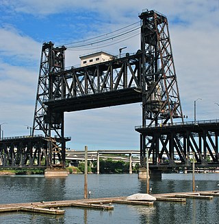
The Steel Bridge is a through truss, double-deck vertical-lift bridge across the Willamette River in Portland, Oregon, United States, opened in 1912. Its lower deck carries railroad and bicycle/pedestrian traffic, while the upper deck carries road traffic, and light rail (MAX), making the bridge one of the most multimodal in the world. It is the only double-deck bridge with independent lifts in the world and the second oldest vertical-lift bridge in North America, after the nearby Hawthorne Bridge. The bridge links the Rose Quarter and Lloyd District in the east to Old Town Chinatown neighborhood in the west.

<span class="mw-page-title-main">Pedestrian zone</span> Urban car-free area reserved for pedestrian use

Pedestrian zones are areas of a city or town reserved for pedestrian-only use and in which most or all automobile traffic is prohibited. Converting a street or an area to pedestrian-only use is called pedestrianisation.

<span class="mw-page-title-main">Nicollet Mall</span> Shopping, transit and pedestrian space in Minneapolis

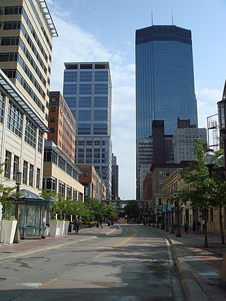
Nicollet Mall is a twelve-block portion of Nicollet Avenue running through downtown Minneapolis, Minnesota, United States. It is the shopping and dining district of the city, and also a pedestrian mall and transit mall. Along with Hennepin Avenue to the west, Nicollet Mall forms the cultural and commercial center of Minneapolis.

<span class="mw-page-title-main">Pedestrian malls in the United States</span>

Pedestrian malls, also known as pedestrian streets, are the most common form of pedestrian zone in large cities in the United States. They are typically streets lined with storefronts and closed off to most automobile traffic. Emergency vehicles may have access at all times and delivery vehicles may be restricted to either limited delivery hours or entrances on side streets.

<span class="mw-page-title-main">Morrison Bridge</span> Bridge in Oregon, U.S.

The Morrison Bridge is a bascule bridge that spans the Willamette River in Portland, Oregon. Completed in 1958, it is the third bridge at approximately the same site to carry that name. It is one of the most heavily used bridges in Portland. It was added to the National Register of Historic Places in November 2012.

<span class="mw-page-title-main">Oregon Route 126</span> State highway in Oregon

Oregon OR 126 (OR 126) is a 204.63-mile-long (329.32 km) state highway that connects coastal, western, and central parts of the U.S. state of Oregon. A short freeway section of OR 126 in Eugene and Springfield is concurrent with Interstate 105 (I-105).

<span class="mw-page-title-main">Transportation in Portland, Oregon</span> Overview of movement of goods and passengers in Portland

Like transportation in the rest of the United States, the primary mode of local transportation in Portland, Oregon is the automobile. Metro, the metropolitan area's regional government, has a regional master plan in which transit-oriented development plays a major role. This approach, part of the new urbanism, promotes mixed-use and high-density development around light rail stops and transit centers, and the investment of the metropolitan area's share of federal tax dollars into multiple modes of transportation. In the United States, this focus is atypical in an era when automobile use led many areas to neglect their core cities in favor of development along interstate highways, in suburbs, and satellite cities.

Portland is "an international pioneer in transit orientated developments."

<span class="mw-page-title-main">Ithaca Commons</span> Place of local interest in New York State

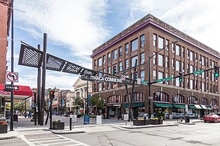
The Ithaca Commons is a two-block pedestrian mall in the business improvement district known as Downtown Ithaca that serves as the city's cultural and economic center. The Commons is a popular regional destination, and is filled with upscale restaurants and shops, public art, and frequent community festivals.

<span class="mw-page-title-main">Downtown Portland, Oregon</span> Neighborhood in Portland, Oregon, United States

Downtown Portland is the city center of Portland, Oregon, United States. It is on the west bank of the Willamette River in the northeastern corner of the southwest section of the city and where most of the city's high-rise buildings are found.

<span class="mw-page-title-main">Harbor Drive</span> Road of historical significance in Portland, Oregon

Harbor Drive is a short roadway in Portland, Oregon, spanning a total length of 0.7 miles (1.1 km), which primarily functions as a ramp to and from Interstate 5. It was once much longer, running along the western edge of the Willamette River in the downtown area. Originally constructed from 1942–43, the vast majority of the road was replaced with Tom McCall Waterfront Park in the 1970s. Signed as U.S. Route 99W, it had been the major route through the city and its removal is often cited as the first instance of freeway removal in the U.S. and as a milestone in urban planning; the original road is remembered as the first limited-access highway built in the city.

<span class="mw-page-title-main">Emerald Express</span> BRT system in Eugene and Springfield, Oregon

The Emerald Express (EmX) is a bus rapid transit (BRT) system in the Eugene-Springfield metropolitan area in Oregon, United States. It is provided by the Lane Transit District (LTD) which is the public transit authority in Lane County, Oregon.

<span class="mw-page-title-main">Downtown Norfolk, Virginia</span> Central Business District

Downtown Norfolk serves as the traditional center of commerce, government, and culture in the Hampton Roads region. Norfolk, Virginia's downtown waterfront shipping and port activities historically played host to numerous and often noxious port and shipping-related uses. With the advent of containerized shipping in the mid-19th century, the shipping uses located on Norfolk's downtown waterfront became obsolete as larger and more modern port facilities opened elsewhere in the region. The vacant piers and cargo warehouses eventually became a blight on downtown and Norfolk's fortunes as a whole. But in the second half of the century, Norfolk had a vibrant retail community in its suburbs; companies like Smith & Welton, High's, Colonial Stores, Goldman's Shoes, Lerner Shops, Hofheimer's, Giant Open Air, Dollar Tree and K & K Toys were regional leaders in their respective fields. Norfolk was also the birthplace of Econo-Travel, now Econo Lodge, one of the nation's first discount motel chains.

<span class="mw-page-title-main">Interstate 5 in Oregon</span> Interstate highway in Oregon

Interstate 5 (I-5) in the U.S. state of Oregon is a major Interstate Highway that traverses the state from north to south. It travels to the west of the Cascade Mountains, connecting Portland to Salem, Eugene, Medford, and other major cities in the Willamette Valley and across the northern Siskiyou Mountains. The highway runs 308 miles (496 km) from the California state line near Ashland to the Washington state line in northern Portland, forming the central part of Interstate 5's route between Mexico and Canada.

<span class="mw-page-title-main">Rizal Avenue</span> Major road in northern Manila, Philippines

Rizal Avenue, also known as Avenida or Avenida Rizal, is one of Manila's main thoroughfares running from its Santa Cruz and Quiapo districts to the Bonifacio Monument (Monumento) Circle in Caloocan. Named after the national hero José Rizal, it is a part of Radial Road 9 (R-9). The LRT Line 1 elevated railroad is built above the street in its entire length, and several jeepneys ply the area taking passengers from Caloocan, Quezon City, and Valenzuela. Most of the street is within Santa Cruz, Manila. By the 1960s, economic activities shifted from Binondo to Makati. The avenue forms part of National Route 150 (N150) of the Philippine highway network.

The Pei Plan was an urban redevelopment initiative designed for downtown Oklahoma City, Oklahoma, United States, in the 1960s and 1970s. It is the informal name for two related commissions of noted architect and urban planner I. M. Pei — namely the Central Business District General Neighborhood Renewal Plan and the Central Business District Project I-A Development Plan. It was formally adopted in 1965, and implemented in public and private phases throughout the 1960s and 1970s.

<span class="mw-page-title-main">Willamette Town Center</span> Shopping mall in Oregon, United States

Willamette Town Center, formerly Lancaster Mall, is an exterior entrance shopping center located in Salem, Oregon, United States. Opened in 1971, the main part of the center has 550,000 square feet (51,000 m2) of space. The regional mall is located on Lancaster Drive and is bordered on the West by Interstate 5, making Willamette Town Center a retail hub for the city of Salem.

Ruth Ellen Bascom was an American politician who served as the first female mayor of Eugene, Oregon, from 1993 until 1996.

<span class="mw-page-title-main">Kalamazoo Mall</span> First outdoor pedestrian shopping mall in the United States

The Kalamazoo Mall, the first outdoor pedestrian shopping mall in the United States, is a section of Burdick Street in downtown Kalamazoo, Michigan.

<span class="mw-page-title-main">Fulton Mall (Fresno)</span>

The Fulton Mall was a six-block corridor in downtown Fresno, California which was closed to traffic in 1964 and made into a pedestrians only mall. Despite opening to much fanfare, the downtown mall suffered from the city's suburban expansion, especially the opening of the Fashion Fair Mall six miles to the north. By the 1980s, most storefronts on the mall were empty and plans to renovate the mall were discussed. In 2017, car traffic was reintroduced to the street after most the public art and amenities had been relocated to sidewalk areas.

<span class="mw-page-title-main">Plaza 8</span> Pedestrian mall in Sheboygan, Wisconsin, U.S.

Plaza 8 was a pedestrian mall located in Downtown Sheboygan, Wisconsin. The mall stretched three and half city blocks in length from Ontario Avenue south past New York Avenue on North 8th Street. The area is now the Harbor Centre Downtown.

References

  1. Kenyon, Ed (February 12, 1971). "Showpiece Mall to be dedicated tomorrow". Eugene Register Guard. Eugene, Oregon: Guard Publishing. pp. 1A. Retrieved October 30, 2013.
  2. Kenyon, Ed (February 12, 1971). "3-day salute to Mall starts Saturday". Eugene Register Guard. Eugene, Oregon: Guard Publishing. pp. 2B. Retrieved October 30, 2013.
  3. Maben, Scott (September 4, 2001). "On the block: The fate of Eugene's pedestrian mall is in the hands of city voters". Eugene Register Guard. Eugene, Oregon: Guard Publishing. pp. 1A. Retrieved October 30, 2013.
  4. 1 2 3 Floyd, Don (October 12, 1975). "Urban renewal: a step toward the future". Eugene Register Guard. Eugene, Oregon: Guard Publishing. pp. II 19. Retrieved October 30, 2013.
  5. In Eugene, for example, out of 186 buildings targeted by urban renewal officials before 1975, 115 were demolished, 53 were "rehabilitated," and only 18 were left untouched.
  6. 1 2 Bates, Kai (2013), Masters Thesis: Making Pedestrian Malls Work (PDF), Eugene, Oregon: University of Oregon, pp. Abstract, archived from the original (PDF) on 2013-11-02, retrieved 2013-11-01
  7. Newcomb, Bob (March 31, 1963). "1980 Eugene: What a Wonderful Town!". Eugene Register Guard. Eugene, Oregon: Guard Publishing. pp. D1. Retrieved October 30, 2013.
  8. 1 2 Holt, Cathleen; Brooks, Cheri, eds. (2000). Eugene 1945-2000 (First ed.). Eugene, Oregon: City Club of Eugene. pp. 89–96. ISBN   0-7388-4581-7.
  9. Wasmann, William (December 22, 1968). "Eugene UR Project No Boondoggle". Eugene Register Guard. Eugene, Oregon: Guard Publishing. pp. 14A. Retrieved October 30, 2013.
  10. Kenyon, Ed (February 12, 1971). "Dedication marks end of chapter that started long ago". Eugene Register Guard. Eugene, Oregon: Guard Publishing. pp. 4B. Retrieved October 30, 2013.
  11. Newcomb, Bob (August 3, 1969). "What's the Future For the Others?". Eugene Register Guard. Eugene, Oregon: Guard Publishing. pp. 22H. Retrieved October 30, 2013.
  12. "How traffic will circle downtown Eugene". Eugene Register Guard. Eugene, Oregon: Guard Publishing. May 2, 1970. pp. 4A. Retrieved October 30, 2013.
  13. Bishop, Sandra; Nelson, Vickie (December 2011). Tie Dye and Tofu: How Mainstream Eugene Became a Counterculture Haven (Third ed.). Eugene, Oregon: Lane County Historical Museum. pp. 67–77. ISBN   978-0-9648434-6-2.
  14. Kenyon, Ed (June 16, 1971). "City adopts tough mall rules". Eugene Register Guard. Eugene, Oregon: Guard Publishing. pp. 1A. Retrieved October 30, 2013.
  15. "Ban on mall dances heads for court test". Eugene Register Guard. Eugene, Oregon: Guard Publishing. July 11, 1971. pp. 1A. Retrieved October 30, 2013.
  16. Burdick, Ginny (March 28, 1972). "EWEB cost for mall job $295,000". Eugene Register Guard. Eugene, Oregon: Guard Publishing. pp. 15C. Retrieved October 30, 2013.
  17. "Downtown parking: No-time-limit plan on ballot". Eugene Register Guard. Eugene, Oregon: Guard Publishing. March 28, 1972. pp. 15C. Retrieved October 30, 2013.
  18. Wyant, Dan (June 15, 1975). "What's future for retailers?". Eugene Register Guard. Eugene, Oregon: Guard Publishing. pp. 3E. Retrieved October 30, 2013.
  19. Matassa, Mark (November 1, 1984). "City votes to reopen mall block". Eugene Register Guard. Eugene, Oregon: Guard Publishing. pp. 1A. Retrieved October 30, 2013.
  20. Barker, George (August 28, 1985). "Plan for new downtown mall discarded". Eugene Register Guard. Eugene, Oregon: Guard Publishing. pp. 1A. Retrieved October 30, 2013.
  21. Prichard, Hugh (April 30, 1995). "Will reopening Willamette Street work? A revitalized Olive Street is proof that it can". Eugene Register Guard. Eugene, Oregon: Guard Publishing. pp. 1C. Retrieved October 30, 2013.
  22. Maben, Scott (September 19, 2001). "Voters OK reopening, nix change in election". Eugene Register Guard. Eugene, Oregon: Guard Publishing. pp. 1A. Retrieved October 30, 2013.
  23. "The end of an era at PHMG". PeaceHealth Medical Group. January 10, 2012. Archived from the original on November 3, 2013. Retrieved October 31, 2013.
  24. Pittman, Alan (May 14, 2009). "Fleeing Downtown". Eugene Weekly. Retrieved October 31, 2013.
  25. Harrington, Elissa (June 25, 2010). "Eugene police station move planned for 2012". KVAL News. Retrieved October 31, 2013.