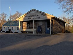
Eva, Tennessee

Last updated

Eva
CDP
Eva-tennessee-post-office1.jpg
Eva post office
USA Tennessee location map.svg
Red pog.svg
Eva
Usa edcp location map.svg
Red pog.svg
Eva
Coordinates: 36°03′52″N88°00′15″W / 36.06444°N 88.00417°W / 36.06444; -88.00417
Country United States
State Tennessee
County Benton
Area
[1]
  Total2.03 sq mi (5.26 km2)
  Land1.99 sq mi (5.15 km2)
  Water0.04 sq mi (0.10 km2)
Elevation
417 ft (127 m)
Population
 (2020) [2]
  Total239
  Density120.10/sq mi (46.37/km2)
Time zone UTC-6 (Central (CST))
  Summer (DST) UTC-5 (CDT)
ZIP code
38333 [3]
Area code 731
GNIS feature ID1646854 [4]

Eva is an unincorporated community and census-designated place (CDP) in Benton County, Tennessee, on the western shore of the Kentucky Lake impoundment of the Tennessee River. It is the site of Nathan Bedford Forrest State Park. As of the 2010 census, its population was 293. [5] The ZIP Code Tabulation Area for the ZIP code (38333) that serves Eva had a population of 574 as of the 2000 U.S. Census, when Eva was not yet a CDP. [6] Eva is centered on the junction of State Route 191, which connects the community to Nathan Bedford Forrest State Park to the north and the town of Camden to the south, and Eva Beach Road, which stretches from the center of the community to its beach along Kentucky Lake.

According to local lore, Eva was named after a friend of the daughter of Benton County land speculator A.W. Lucas. In 1913, Lucas donated land for a church and school that became the core of the community. [7]

In 1940, before the Tennessee River was dammed to form Kentucky Lake, University of Tennessee archaeologists excavated a rich archaeological site at Eva, containing the remains of a series of prehistoric Native American encampments dating from the Archaic Period. The earliest remains at the site, with a radiocarbon date of 5200 B.C., contained artifacts from a group of hunting and gathering people who were named the Eva culture after the site, which is now submerged by the reservoir. [8]

Historical population
CensusPop.Note
2020 239
U.S. Decennial Census [9]

Related Research Articles

<span class="mw-page-title-main">Benton County, Tennessee</span> County in Tennessee, United States

Benton County is a county located in the U.S. state of Tennessee. As of the 2020 census, the population was 15,864. Its county seat is Camden. The county was created in December 1835 and organized in 1836.

<span class="mw-page-title-main">Marshall County, Kentucky</span> County in Kentucky, United States

Marshall County is a county located in far western portion of the U.S. state of Kentucky. As of the 2020 census, the population was 31,659. Its county seat is Benton.

<span class="mw-page-title-main">Camden, Tennessee</span> City in Tennessee, United States

Camden is a city in Benton County, Tennessee. The population was 3,674 at the 2020 census. It is the county seat of Benton County.

<span class="mw-page-title-main">Waverly, Tennessee</span> City in Tennessee, United States

Waverly is a city in and the county seat of Humphreys County, Tennessee, United States. The population was 4,297 at the 2020 census.

A census-designated place (CDP) is a concentration of population defined by the United States Census Bureau for statistical purposes only.

<span class="mw-page-title-main">Thorofare, New Jersey</span> Populated place in Gloucester County, New Jersey, US

Thorofare is an unincorporated community and census-designated place (CDP) located within West Deptford Township in northwestern Gloucester County, situated in the South Jersey region of the U.S. state of New Jersey. The area is served as United States Postal Service ZIP Code 08086. As of the 2020 United States census, the CDP's population was 2,806. As of the 2000 census, the population of a different geographic entity containing Thorofare, namely ZIP Code Tabulation Area 08086, was 5,424.

<span class="mw-page-title-main">Nathan Bedford Forrest State Park</span> State park in Tennessee, United States

Nathan Bedford Forrest State Park is a state park in Benton County, Tennessee, in the southeastern United States. The park is situated on the western shore of the Kentucky Lake impoundment of the Tennessee River, just north of the community of Eva. Established in 1929, the park consists of 2,587 acres (10.47 km2) managed by the Tennessee Department of Environment and Conservation.

<span class="mw-page-title-main">Newport, Cumberland County, New Jersey</span> Populated place in Cumberland County, New Jersey, US

Newport is an unincorporated community and census-designated place (CDP) located within Downe Township in Cumberland County, in the U.S. state of New Jersey. The area is served as United States Postal Service ZIP Code 08345.

Dukedom is an unincorporated community in both Graves County, Kentucky and Weakley County, Tennessee, straddling the state line in the western part of both states. The location is 36°30′8″N88°42′54″W; The elevation is 487 feet above sea level.

<span class="mw-page-title-main">Layton, New Jersey</span> Populated place in Sussex County, New Jersey, US

Layton is an unincorporated community and census-designated place (CDP) located within Sandyston Township in Sussex County, in the U.S. state of New Jersey. The area is served as United States Postal Service ZIP Code 07851.

<span class="mw-page-title-main">Delaware, Warren County, New Jersey</span> Census-designated place in Middlesex County, New Jersey, US

Delaware is an unincorporated community and census-designated place (CDP) located along the Delaware River within Knowlton Township in Warren County, New Jersey. It was created as part of the 2010 United States Census. As of the 2010 Census, the CDP's population was 150. The area is served as United States Postal Service ZIP Code 07833.

New Gretna is an unincorporated community and census-designated place (CDP) located within Bass River Township in Burlington County, in the U.S. state of New Jersey. The area is served as United States Postal Service ZIP Code 08224.

<span class="mw-page-title-main">Jacks Creek, Tennessee</span> Unincorporated community in Tennessee, United States

Jacks Creek is an unincorporated community in Chester County, Tennessee, United States.

<span class="mw-page-title-main">Asbury, New Jersey</span> Populated place in Warren County, New Jersey, US

Asbury is an unincorporated community and census-designated place (CDP) located within Franklin Township in Warren County, in the U.S. state of New Jersey, that was created as part of the 2010 United States Census. As of the 2010 Census, the CDP's population was 273.

<span class="mw-page-title-main">Clairfield, Tennessee</span> Unincorporated community in Tennessee, United States

Clairfield is an unincorporated community in Claiborne County, Tennessee, United States. It is located in the upper Clearfork Valley in the Cumberland Mountains of northeastern Tennessee. It is the site of a post office, assigned ZIP code 37715. The population of the Zip Code Tabulation Area corresponding to Clairfield's ZIP code was 1,002 as of the 2000 Census.

<span class="mw-page-title-main">Eva site</span> Prehistoric Native American site in Benton County, Tennessee

The Eva site (40BN12) is a prehistoric Native American site in Benton County, Tennessee, in the Southeastern United States. Located along an ancient channel of the Tennessee River, the Eva site saw extensive periods of occupation during the Middle and Late Archaic period. The site's well-defined midden layers helped investigators identify three distinct Archaic cultures, the oldest of which was first identified at Eva and is still known as the "Eva culture" or the "Eva phase."

<span class="mw-page-title-main">Harrisonville, New Jersey</span> Populated place in Gloucester County, New Jersey, US

Harrisonville is an unincorporated community and census-designated place (CDP) located within South Harrison Township, in Gloucester County, in the U.S. state of New Jersey. The area is served as United States Postal Service ZIP Code 08039.

<span class="mw-page-title-main">Hilham, Tennessee</span> Unincorporated community in Tennessee, United States

Hilham is an unincorporated community in Overton County, Tennessee. The community is situated around the junction of Tennessee State Route 136 and Tennessee State Route 85. Although not a census-designated place, Hilham is part of a Zip Code Tabulation Area (38568) that covers most of rural northwest Overton County and part of northeast Jackson County. As of the 2000 census, the population of this entire area was less than 2000.

<span class="mw-page-title-main">Andersonville, Tennessee</span> CDP in Tennessee, United States

Andersonville is an unincorporated community in Anderson County, Tennessee. Beginning with the 2010 census, it is treated as a census-designated place (CDP). The CDP had a population of 508 in 2020.

<span class="mw-page-title-main">Pocahontas, Tennessee</span> Census-designated place in Tennessee, United States

Pocahontas is an unincorporated community and census-designated place (CDP) in Hardeman and McNairy counties, Tennessee, United States. It is eighty-three miles southeast of Memphis.

References

  1. "ArcGIS REST Services Directory". United States Census Bureau. Retrieved October 15, 2022.
  2. "Census Population API". United States Census Bureau. Retrieved October 15, 2022.
  3. United States Postal Service (2012). "USPS - Look Up a ZIP Code" . Retrieved February 15, 2012.
  4. "Bowman". Geographic Names Information System . United States Geological Survey, United States Department of the Interior.
  5. "U.S. Census website". United States Census Bureau . Retrieved May 14, 2011.
  6. U.S. Department of Commerce, Bureau of the Census, "Zip Code Tabulation Area 38333 Fact Sheet Archived 2020-02-12 at archive.today ." Retrieved: December 12, 2007.
  7. Nell Morisette, "Flashbacks in the History of Eva, Tennessee." TNGenWeb.org, 1998-2002. Retrieved: December 12, 2007.
  8. Charles Faulkner, Eva Site, Tennessee Encyclopedia of History and Culture (accessed December 11, 2007)
  9. "Census of Population and Housing". Census.gov. Retrieved June 4, 2016.