
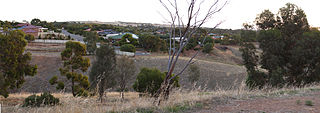
One Tree Hill is a town on the outskirts of Adelaide, South Australia. It is located in the City of Playford.
The Kaurna people are a group of Aboriginal people whose traditional lands include the Adelaide Plains of South Australia. They were known as the Adelaide tribe by the early settlers. Kaurna culture and language were almost completely destroyed within a few decades of the British colonisation of South Australia in 1836. However, extensive documentation by early missionaries and other researchers has enabled a modern revival of both language and culture. The phrase Kaurna meyunna means "Kaurna people".

Victoria Square, also known as Tarntanyangga, is the central square of five public squares in the Adelaide city centre, South Australia.

The Town of Gawler is a local government area located north of Adelaide city centre in South Australia containing Gawler and its suburbs. The corporate town was established in 1857 due to the township's residents' dissatisfaction at being governed by three different district councils.

The Adelaide Park Lands are the figure-eight of land spanning both banks of the River Torrens between Hackney and Thebarton and separating the City of Adelaide area from the surrounding suburbia of greater metropolitan Adelaide, the capital city of South Australia. They were laid out by Colonel William Light in his design for the city, and originally consisted of 2,300 acres (930 ha) "exclusive of 32 acres (13 ha) for a public cemetery". One copy of Light's plan shows areas for a cemetery and a Post and Telegraph Store on West Tce, a small Government Domain and Barracks on the central part of North Tce, a hospital on East Tce, a Botanical Garden on the River Torrens west of North Adelaide, and a school and a storehouse south-west of North Adelaide.

The Adelaide Plains is a plain in South Australia lying between the coast on the west and the Mount Lofty Ranges on the east. The southernmost tip of the plain is in the southern seaside suburbs of Adelaide around Brighton at the foot of the O'Halloran Hill escarpment with the south Hummocks Range and Wakefield River roughly approximating the northern boundary.

The South Australian Museum is a natural history museum and research institution in Adelaide, South Australia, founded in 1856 and owned by the Government of South Australia. It occupies a complex of buildings on North Terrace in the cultural precinct of the Adelaide Parklands. Plans are under way to move much of its Australian Aboriginal cultural collection, into a new National Gallery for Aboriginal Art and Cultures.
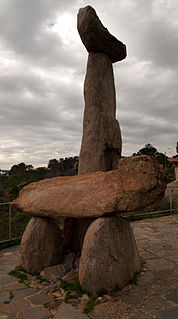
Tjilbruke is an important creation ancestor for the Kaurna people of the Adelaide plains in the Australian state of South Australia. Tjilbruke was a Kaurna man, who appeared in Kaurna Dreaming dating back about 11,000 years. The Tjilbruke Dreaming Track or Tjilbruke Dreaming Trail is a major Dreaming trail, which connects sites from within metropolitan Adelaide southwards as far as Cape Jervis, some of which are Aboriginal sacred sites of great significance.

Warriparinga, also spelt Warriparingga, is a nature reserve comprising 3.5 hectares in the metropolitan suburb of Bedford Park, in the southern suburbs of Adelaide, South Australia. Also known as Fairford, Laffer's Triangle and the Sturt Triangle, Warriparinga is bordered by Marion Road, Sturt Road and South Road, and is traversed by the Sturt River as it exists from Sturt Gorge to travel west across the Adelaide Plains.

Light Square, also known as Wauwi, is one of five public squares in the Adelaide city centre. Located in the centre of the north-western quarter of the Adelaide city centre, its southern boundary is Waymouth Street, while Currie Street crosses its northern tip, isolating about a quarter of its land. Morphett Street runs through the centre in a north-south direction.

Moana is an outer coastal suburb in the south of Adelaide, South Australia. The suburb is approximately 36.4 km from the Adelaide city centre. It lies within the City of Onkaparinga local government area, and neighbours the suburbs Seaford, Maslin Beach, Seaford Rise and Port Noarlunga It is divided into two by Pedlar Creek and the associated sand dune reserve. The beach is often referred to as Moana Beach.
Yankalilla is an agriculturally based town situated on the Fleurieu Peninsula in South Australia, located 72 km south of the state's capital of Adelaide. The town is nestled in the Bungala River valley, overlooked by the southern Mount Lofty Ranges and acts as a service centre for the surrounding agricultural district.
Kingston Park is a small beachside suburb, 17 kilometres (11 mi) south of the Adelaide city centre. Kingston Park is within the City of Holdfast Bay and flanked by the neighbouring suburbs of Marino to the south and Seacliff to the north and east.
Hallett Cove Conservation Park is a protected area in the Australian state of South Australia located in the suburb of Hallett Cove on the coast of Gulf St Vincent about 22 kilometres south of the centre of the state capital of Adelaide.
Craigmore is a large suburb north of Adelaide, South Australia. It is in the City of Playford local government area, just east of Elizabeth and south of Gawler.
The repatriation and reburial of human remains is a current issue in archaeology and museum management, centering on ethical issues and cultural sensitivities regarding human remains of long-deceased ancestors which have ended up in museums and other institutions. Historical trauma as a result of colonialism is often involved. Various indigenous peoples around the world, such as Native Americans and Indigenous Australians, have requested that human remains from their respective communities be repatriated to their local areas and burial sites from various institutions, often in other countries, for reburial.
Munno Para is a northern suburb of Adelaide, South Australia. It is located in the City of Playford.

Wirrina Cove is a locality and holiday resort on the Fleurieu Peninsula, South Australia. It is located between the coastal towns of Second Valley and Normanville on Yankalilla Bay. The holiday resort was developed from around 1972, and is located about 90 kilometres (56 mi) south of Adelaide.

The Hundred of Munno Para is a cadastral unit of hundred covering the outer northern suburbs of Adelaide north of the Little Para River and the flanking semi-rural areas in South Australia. It is one of the eleven hundreds of the County of Adelaide. It was named in 1846 by Governor Frederick Robe, Munno Para being a term from a local Kaurna Aboriginal people meaning golden wattle creek. This name refers to either the Gawler River or the Little Para River.
Christian Gottlieb Teichelmann, also spelt Christian Gottlob Teichelmann, was a Lutheran missionary who worked among Australian Aboriginal people in South Australia. He was a pioneer in describing the Kaurna language, after his work begun at the Piltawodli Native Location in Adelaide, with fellow-missionary Clamor Wilhelm Schürmann.
