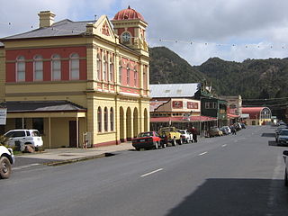
Queenstown is a town in the West Coast region of the island of Tasmania, Australia. It is in a valley on the western slopes of Mount Owen on the West Coast Range.
Swansea is a town in the heart of Tasmania's east coast, on the north-west shore of Great Oyster Bay and overlooking Freycinet National Park. It was the first municipality in Australia to be established after Hobart and Sydney. At the 2006 census, Swansea had a population of 557.

Kingston is a town on the outskirts of Hobart, Tasmania, Australia. Nestled 12 km south of the city between and around several hills, Kingston is the seat of the Kingborough Council, and today serves as the gateway between Hobart and the D'Entrecasteaux Channel region, which meets the Derwent River nearby. It is one of the fastest-growing regions in Tasmania. The Kingston-Huntingfield statistical area had an estimated population of 11,200 in June 2012.

Norseman is a town located in the Goldfields-Esperance region of Western Australia along the Coolgardie-Esperance Highway, 726 kilometres (451 mi) east of Perth and 278 metres (912 ft) above sea level. It is also the starting point of the Eyre Highway, and the last major town in Western Australia before the South Australian border 720 kilometres (447 mi) to the east. At the 2016 census, Norseman had a population of almost 600.
West Tamar Council is a local government body in Tasmania, situated along the western side of the Tamar River in the north of the state. West Tamar is classified as an urban local government area and has a population of 23,769, it extends from the outer reaches of north-west Launceston and includes the towns and localities of Beaconsfield, Beauty Point and Legana.

Huonville is a town on the Huon River, in the south-east of Tasmania, Australia. It is the seat of the Huon Valley Council area and lies 38 km south of Hobart on the Huon Highway. At the 2016 census, Huonville had a population of 2,714 and at the 2011 census had a population of 1,741.

Wynyard (/ˈwɪnjɚd/) wi-nyuhd) is a rural town located on the North West coast of Tasmania, Australia. Wynyard is situated 17 kilometres (11 mi) west of Burnie. As of the 2016 census, Wynyard has an estimated urban population of 5,168 and a total greater area population of 6,001. The town is a regional hub servicing the surrounding rural areas, the adjacent Burnie Wynyard Airport provides commercial flights to Melbourne and other districts. The main council offices for the Waratah-Wynyard local government area are located in Wynyard.
Gayndah is a town and locality in the North Burnett Region, Queensland, Australia. In the 2016 census, Gayndah had a population of 1,981 people. It is the administrative centre for the North Burnett Region.

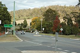
Bracknell is a rural locality and town in the local government areas of Meander Valley and Northern Midlands in the Launceston and Central regions of Tasmania. The locality is about 22 kilometres (14 mi) south-east of the town of Westbury. The 2016 census has a population of 459 for the state suburb of Bracknell.

Caveside is a rural locality in the local government area of Meander Valley in the Launceston region of Tasmania. The locality is about 45 kilometres (28 mi) south-west of the town of Westbury. It lies between the Great Western Tiers to the south and Mole Creek to the north. The 2016 census has a population of 133 for the state suburb of Caveside.

Lilydale, originally known as Upper Piper, is a small town in northern Tasmania, Australia. The town is 28 kilometres (17 mi) northeast of Launceston and is a part of the Launceston municipality, except for about 4% which is in the Dorset LGA. It is located near Mount Arthur. At the 2016 census, Lilydale had a population of 277. The town's notable attractions include the Lilydale Falls, two small waterfalls, Mount Arthur, and, along the main street, a series of telegraph poles painted with murals.

Woodbridge is a semi-rural locality in the local government area (LGA) of Kingborough in the Hobart LGA region of Tasmania. The locality is about 26 kilometres (16 mi) south of the town of Kingston. The 2016 census has a population of 503 for the state suburb of Woodbridge. It is located 38 kilometres (24 mi) south of the state capital, Hobart.

Hamilton is a rural locality in the local government area (LGA) of Central Highlands in the Central LGA region of Tasmania. The locality is about 73 kilometres (45 mi) north-west of the town of Hobart. The 2016 census provides a population of 211 for the state suburb of Hamilton.
Winnaleah is a rural / residential locality in the local government area (LGA) of Dorset in the North-east LGA region of Tasmania. The locality is about 38 kilometres (24 mi) north-east of the town of Scottsdale. The 2016 census provides a population of 225 for the state suburb of Winnaleah.
Huntingfield is a residential locality in the local government area (LGA) of Kingborough in the Hobart LGA region of Tasmania. The locality is about 3 kilometres (1.9 mi) south-west of the town of Kingston. The 2016 census provides a population of 428 for the state suburb of Huntingfield.

Riverside is a rural and urban locality in the local government areas of Meander Valley and West Tamar in the Launceston region of Tasmania. The locality is about 39 kilometres (24 mi) south-east of the town of Beaconsfield. The 2016 census has a population of 6472 for the state suburb of Riverside. It is a residential suburb 5 kilometres (2.5 mi) north-west of the central business district of Launceston, Tasmania's second largest city. The West Tamar Highway runs through the suburb, adjoining Riverside to the West Tamar, which includes small towns: Beaconsfield, and Beauty Point. Riverside is part of the West Tamar Council local government area. The suburb is now Launceston's largest by population, narrowly ahead of Kings Meadows. The main shopping centre opened in the 1960s and includes: a Woolworths supermarket, a Banjos bakery, a pharmacist and several retail shops.

Ringarooma is a small town in north-eastern Tasmania. It is located just east of the Ringarooma River and is about 12 km (7.5 mi) south-west from Derby and 55 km (34 mi) east-northeast from Launceston. The area around Ringarooma is known for Dairy farming and timber harvesting. The locality is in the Dorset Council LGA, except for about 2.5% which is in the Break O'Day Council area.

Hagley is a rural locality and town in the local government area of Meander Valley in the Launceston region of Tasmania. The locality is about 5 kilometres (3.1 mi) north-east of the town of Westbury. The 2016 census has a population of 335 for the state suburb of Hagley.
Chudleigh is a rural locality in the local government area of Meander Valley in the Launceston region of Tasmania. The locality is about 37 kilometres (23 mi) west of the town of Westbury. The 2016 census has a population of 203 for the state suburb of Chudleigh.

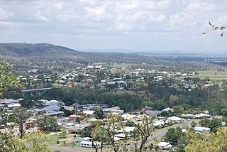
Upper Burnie is a residential locality in the local government area (LGA) of Burnie in the North-west and west LGA region of Tasmania. The locality is about 3 kilometres (1.9 mi) south of the town of Burnie. The 2016 census provides a population of 1821 for the state suburb of Upper Burnie. It is a suburb of Burnie in north-west Tasmania. It is situated on the hill above Burnie accessed via Mount Street.