
The Old Red Sandstone is an assemblage of rocks in the North Atlantic region largely of Devonian age. It extends in the east across Great Britain, Ireland and Norway, and in the west along the northeastern seaboard of North America. It also extends northwards into Greenland and Svalbard. These areas were a part of the ancient continent of Euramerica/Laurussia. In Britain it is a lithostratigraphic unit to which stratigraphers accord supergroup status and which is of considerable importance to early paleontology. For convenience the short version of the term, ORS is often used in literature on the subject. The term was coined to distinguish the sequence from the younger New Red Sandstone which also occurs widely throughout Britain.

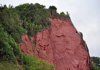
The Lickey Hills are a range of hills in Worcestershire, England, 11 miles (18 km) to the south-west of the centre of Birmingham near the villages of Lickey, Cofton Hackett and Barnt Green. The hills are a popular country park area and they afford panoramic views over much of the surrounding countryside.
The New Red Sandstone, chiefly in British geology, is composed of beds of red sandstone and associated rocks laid down throughout the Permian to the end of the Triassic, that underlie the Jurassic-Triassic age Penarth Group. The name distinguishes it from the Old Red Sandstone which is largely Devonian in age, and with which it was originally confused due to their similar composition.

The Mercia Mudstone Group is an early Triassic lithostratigraphic group which is widespread in Britain, especially in the English Midlands – the name is derived from the ancient kingdom of Mercia which corresponds to that area. It is frequently encountered in older literature as the Keuper Marl or Keuper Marl Series.
The Cwmystwyth Grits Group is a Silurian lithostratigraphic group in mid Wales. The name is derived from the village of Cwmystwyth near Devil's Bridge in Ceredigion. The Group comprises the Blaen Myherin Mudstones Formation, the Glanyrafon Formation, the Caerau Mudstones Formation, the Rhuddnant Grits Formation and the Pysgotwr Grits Formation.

The Fishguard Volcanic Group is an Ordovician lithostratigraphic group in west Wales. The name is derived from the town of Fishguard in Pembrokeshire. This assemblage of rocks has also been referred to as the Fishguard Volcanic Series or Fishguard Volcanic Complex. These rocks are believed to be the source of the 'bluestones' which form a part of the well-known prehistoric monument of Stonehenge in southern England.
The Llanbedrog Volcanic Group is an Ordovician lithostratigraphic group in northwest Wales. The name is derived from the village of Llanbedrog on the Llyn Peninsula where the strata are exposed.
The Snowdon Volcanic Group is an Ordovician lithostratigraphic group in Snowdonia, north-west Wales. The name is derived from Snowdon, the highest peak in Wales where it outcrops. This assemblage of rocks has also been referred to as the Snowdon Volcanic Series.
The Llewelyn Volcanic Group is an Ordovician lithostratigraphic group in Snowdonia, north-west Wales. The name is derived from Carnedd Llewelyn, the highest peak in the Carneddau range where it outcrops.

The Harlech Grits Group is a lower to middle Cambrian lithostratigraphic group in northwest Wales. The name is derived from the town of Harlech in Gwynedd.

The Mawddach Group is a middle to upper Cambrian lithostratigraphic group in Gwynedd, Wales. The name is derived from the river known as the Afon Mawddach.

The Sherwood Sandstone Group is a Triassic lithostratigraphic group which is widespread in Britain, especially in the English Midlands. The name is derived from Sherwood Forest in Nottinghamshire which is underlain by rocks of this age. It has economic importance as the reservoir of the Morecambe Bay gas field, the second largest gas field in the UK.
The Cumbrian Coast Group is a Permian lithostratigraphic group which occurs in the western part of Cumbria in northern England.

The Aylesbeare Mudstone Group is an early Triassic lithostratigraphic group in southwest England. The name is derived from the village of Aylesbeare in east Devon. The Group comprises the Littleham Mudstone Formation, the Exmouth Mudstone and Sandstone Formation and the underlying Clyst St Lawrence Formation. The strata are exposed on the coast between Exmouth and Budleigh Salterton where the type section is defined. The rocks of the Aylesbeare Mudstone Group have also previously been known as the Aylesbeare Group and the Aylesbeare Mudstone Formation.
The Cosheston Group is an early Devonian lithostratigraphic group in west Wales. The name is derived from the village of Cosheston in south Pembrokeshire. The Group comprises the Llanstadwell, Burton Cliff, Mill Bay, Lawrenny Cliff and New Shipping formations. The strata are exposed in the Milford Haven area of southern Pembrokeshire where several partial type sections are defined. The outcrop extends around the northern and southern shores of the Haven. It is bounded to the north by the Benton Fault between the villages of Rosemarket and Lawrenny, and extends east to New Shipping and west almost to the town of Milford Haven itself. The rocks of this group have also previously been known as the Cosheston Beds.

The Milford Haven Group is a late Silurian to early Devonian lithostratigraphic group in west Wales. The name is derived from the estuary and town of Milford Haven in south Pembrokeshire. The Group comprises calcareous marls with occasional sandstones along with conglomerates and breccias.

The Exmoor Group is a late Devonian to early Carboniferous lithostratigraphic group in southwest England whose outcrop extends from Croyde in north Devon east across Exmoor to Minehead in west Somerset. The group comprises the following formations the:
The Eycott Volcanic Group is a group of volcanic rock formations of Ordovician age named after the locality of Eycott Hill in the English Lake District. The group overlies the Skiddaw Group and is unconformably overlain by a variety of different Devonian and Carboniferous age rocks.
This article describes the geology of the Broads, an area of East Anglia in eastern England characterised by rivers, marshes and shallow lakes (‘broads’). The Broads is designated as a protected landscape with ‘status equivalent to a national park’.
The geology of Exmoor National Park in south-west England contributes significantly to the character of a landscape which was designated as a national park in 1954. The bedrock of the area consists almost wholly of a suite of sedimentary rocks deposited during the Devonian, a period named for the English county of Devon in which the western half of the park sits. The eastern part lies within Somerset and it is within this part of the park that limited outcrops of Triassic and Jurassic age rocks are to be found.
