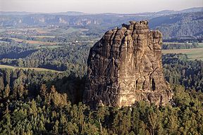
Falkenstein (Saxon Switzerland)

Last updated
Falkenstein
Falkenstein.jpg
The Falkenstein seen from the Schrammsteine
Highest point
Elevation 381.2 m above  sea level (HN) (1,251 ft)
Coordinates 50°55′06″N14°12′04″E / 50.91833°N 14.20111°E / 50.91833; 14.20111
Geography
Saxony relief location map.jpg
Red triangle with thick white border.svg
Falkenstein
Parent range Saxon Switzerland
Geology
Age of rock Cretaceous
Mountain type Sandstone Stage d
Rock summit
Climbing
First ascent 1864 by Schandau gymnasts
Easiest route Schusterweg III

The Falkenstein is one of the best-known climbing peaks in Saxon Switzerland. It is situated near the rocky Schrammsteine ridge southeast of the town of Bad Schandau. The Falkenstein is nearly 90 m high and consists of sandstone. In the Middle Ages there were fortifications on top of the rock. Even today, the steps carved into the rock are still visible.

Contents

History

The Falkenstein was probably built on and used as a castle lookout from the middle of the 14th century. Like almost all of Saxon Switzerland on the right bank of the Elbe, it belonged to the Barony of Hohnstein with its seat at Hohnstein Castle, which was given to the Bohemian noble family of Berka von Dubá in 1353 by Emperor Charles IV as a Bohemian fiefdom. [1]

In 1409 Hinko von der Duba divided the territory among his five sons. The Falkenstein went to his son Henry as part of the new Barony of Wildenstein. He set up his seat of power in the castle at New Wildenstein. In addition to the surrounding villages and towns, the lordship also included other watchtowers, e.g. on the Rauschenstein and the Frienstein. From about 1425, Henry von der Duba was repeatedly feuding with the Lusatian League and the Saxon Electors. His nephews, who inherited the barony around 1435, continued the feuds and attacked villages and merchant trains as robber barons. However, with the exception of the Elbe, there were no trade routes in the immediate vicinity of the Falkenstein. An old communication route from Postelwitz to Sebnitz gave the watchtower strategic importance in these feuds and access to the Elbe and the Kirnitzsch valley. It also secured access from the Elbe to Wildenstein Castle. [2]

Elector Frederick II of Saxony finally besieged the Berkas on the Wildenstein from autumn 1439 to put an end to the feuds. The watchtower on the Falkenstein was probably destroyed during this campaign. The Berkas finally agreed in 1451 to an exchange of the Barony of Wildenstein for part of the Barony of Schluckenau in Bohemia. With this, the Falkenstein finally became Saxon property. In the list of castles created in 1456, the Falkenstein was already one of the watchtowers described as derelict. [3]

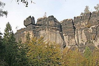
In 1543 and 1547 the rock is mentioned as part of the forests belonging to Hohnstein. The map of the first Electoral Saxon state survey, created by Matthias Oeder in 1592 describes it as "bare and high". [4] During the Thirty Years' War, residents of the surrounding towns hid themselves on the Falkenstein, as weather-beaten inscriptions, including the year "1631", bear witness to. [4] [5]

Pastor Wilhelm Leberecht Götzinger, who was interested in natural history, described the rock in 1804 as inaccessible and only accessible via ladders. In 1812 his proposal to establish and secure an ascent that could be used by tourists was rejected by the Saxon Forestry Commission due to the high costs. [6] In the years that followed, there were occasional reports of ascents, without more precise names and dates being given.

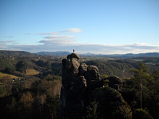
In 1864, the ascent by Schandau gymnasts on the Gymnasts' Route (Turnerweg), which is still known today, marked the birth of Saxon climbing. After lengthy preparations, Gustav Tröger, Ernst Fischer, J. Wähnert and H. Frenzel, all members of the Schandau Men's Gymnastics Club (Männer-Turnvereins zu Schandau), founded in 1847, climbed to the top. They erected a flagpole on the summit and flew three flags from it. Tröger published a report on 2 April 1864 in the Dresden News (Dresdner Nachrichten). The gymnasts still used artificial aids that are not permitted under today's rules. Nevertheless, this first verifiable modern ascent is considered the beginning of climbing in Saxon Switzerland due to its primarily sporting intentions. [7] Another ascent by Dresden gymnasts is documented in 1868, as they chiselled their names into the rock in the exit area. An ascent in 1871 is also documented by the names carved on it. In 1878, on the occasion of the silver wedding of the Saxon royal couple, four members of the Schandau branch of the Saxon Switzerland Mountaineering Club (Gebirgsverein für die Sächsische Schweiz) lit a bonfire on the summit. [8] Plans to create a more generally accessible ascent came up again, which also failed due to lack of funds. [6]

At the end of 1894, a weather vane in the form of a falcon was mounted on the Falkenstein as a summit mark. In 1903 the flag had to be repaired after being damaged. In 1929, the falcon, whose existence had been repeatedly criticized as a blight, disappeared from the summit. A year later, the metal figure was discovered by chance in a crevice in the rock. At first it remained in the possession of a climbing club, since 1951 the falcon has been held by the local history museum of Bad Schandau. [9]

Götzinger was already aware of the existence of the old watchtower. In 1878, during the ascent at that time, a broken medieval clay pot was discovered. In 1892, while descending the Turnerweg after the first ascent of the Schusterweg, Oscar Schuster and Martin Klimmer discovered artificial steps under the vegetation that had been part of the ascent to the watchtower. In 1940, Dresden architect and local historian, Oskar Pusch, carried out a major investigation of the fortification at Falkenstein. Based on the results, he created a graphic reconstruction of the watchtower. [10] He also discovered traces of fire debris, which indicate that the watchtower had been destroyed in fighting. [11]

In 1964 and 1989, festival weeks were held to mark the anniversary of the first ascent. In 1989, a rope team climbed the Turnerweg without using today's climbing shoes and ropes, wearing clothing and equipment based on the first climbers of the time. [12]

Climbing today

Part of the Schrammsteine with the Falkenstein in the background Bad Schandau Schrammsteine und Affensteine asv2023-01 img10.jpg
Part of the Schrammsteine with the Falkenstein in the background

The peak of the Falkenstein can only be reached by skilled climbers. Nowadays more than 100 routes lead to the top. The most popular ascent is Schusterweg (III), which was first climbed by Oskar Schuster  [ de ] in 1893.

Other notable climbs on the 'Falkenstein' (with their Saxon rating grades) are the:

Related Research Articles

<span class="mw-page-title-main">Saxon Switzerland</span> Hilly natural area in Saxony, Germany

Saxon Switzerland is a hilly climbing area and national park in the Elbe Sandstone Mountains. It is located around the Elbe valley south-east of Dresden in Saxony, Germany, adjoining Bohemian Switzerland in the Czech Republic. Together with the Czech part, the region is known as Saxon-Bohemian Switzerland.

<span class="mw-page-title-main">Elbe Sandstone Mountains</span> Mountain range in Germany

The Elbe Sandstone Mountains, also called the Elbe Sandstone Highlands, are a mountain range straddling the border between the state of Saxony in southeastern Germany and the North Bohemian region of the Czech Republic, with about three-quarters of the area lying on the German side. In both countries, core parts of the mountain range have been declared a national park. The name derives from the sandstone which was carved by erosion. The river Elbe breaks through the mountain range in a steep and narrow valley.

<span class="mw-page-title-main">Bad Schandau</span> Town in Saxony, Germany

Bad Schandau is a spa town in Germany, in the Sächsische Schweiz-Osterzgebirge district of Saxony. It is situated on the right bank of the Elbe, at the mouth of the valley of the Kirnitzsch and in the area often described as Saxon Switzerland.

Rudolf Fehrmann was a German climber. He was a pioneer rock climber at the Elbe Sandstone Mountains near Dresden.

<span class="mw-page-title-main">Saxon Switzerland National Park</span> National Park in Saxony, Germany

Saxon Switzerland National Park, is a national park in the German Free State of Saxony, near the Saxon capital Dresden. It covers two areas of 93.5 km2 (36.1 mi2) in the heart of the German part of the Elbe Sandstone Mountains, which is often called (the) Saxon Switzerland.

<span class="mw-page-title-main">Děčín–Dresden-Neustadt railway</span>

The Děčín–Dresden railway, also called the Elbe Valley Railway is an electrified main line in Saxony and the Czech Republic. Formerly called the Saxon-Bohemian State Railway, the line is part of the Dresden to Prague route and is one of Europe's most important trunk routes (Magistralen). It runs along the Elbe Valley from Děčín via Bad Schandau and Pirna to Dresden. The first section of the line was opened in 1848 and is one of the oldest lines in Germany.

<span class="mw-page-title-main">Hohnstein Castle (Saxon Switzerland)</span>

Hohnstein Castle is a medieval castle in the village of the same name, Hohnstein in Saxon Switzerland in the Free State of Sachsen in East Germany.

<span class="mw-page-title-main">Schrammsteine</span>

The Schrammsteine are a long, strung-out, very jagged group of rocks in the Elbe Sandstone Mountains located east of Bad Schandau in Saxon Switzerland in eastern Germany. To the north they are bordered by the Kirnitzsch valley, to the south by the Elbe valley and to the east by the Affensteine rocks. The high point of the chain lies at over 400 m above sea level (HN). The viewing point on the Schrammsteine lies at a height of 417.2 m above HN.

<span class="mw-page-title-main">Climbing rock</span>

A climbing rock is a term used especially in Germany for an individual rock formation, rock face or rock group on which climbing is permitted. Designated climbing rocks are listed in climbing guidebooks and are usually incorporated and marked within the climbing areas of the alpine clubs. The concept is mainly relevant to climbing outside or on the fringes of the Alps. Special climbing regulations normally apply to climbing rocks, such as those for Saxon Switzerland, and there are usually restrictions to take account of conservation laws and requirements.

<span class="mw-page-title-main">Lokomotive</span>

The Lokomotive is a striking climbing rock north of Kurort Rathen in Saxon Switzerland in Germany. The rock, which resembles a steam locomotive in appearance, is also known as Große Ruine, is about 30 metres high and is divided into two parts: known as Lokomotive-Dom and Lokomotive-Esse. The ridge between the two is called the Kesselgrat, the rock teeth next to the Esse as Pfeife ("Whistle"). For a short time there was a weather vane on the dome in the shape of a wheel. The Lokomotive rises on the massif of the Honigsteine.

<span class="mw-page-title-main">Mönch (rock)</span>

The Mönch is a rock pinnacle and popular climbing peak in Saxon Switzerland in Germany near the spa town of Rathen. The weather vane on the summit, in the shape of a tin monk, is visible from afar and acts as a navigation aid.

<span class="mw-page-title-main">Quirl</span> Mountain in Germany

The Quirl is a low table hill, 349 metres high, in Saxon Switzerland, west of the River Elbe.

<span class="mw-page-title-main">Saxon Switzerland climbing region</span> Climbing area in Germany

Saxon Switzerland is the largest and one of the best-known rock climbing regions in Germany, located in the Free State of Saxony. The region is largely coterminous with the natural region of the same name, Saxon Switzerland, but extends well beyond the territory of the National Park within it. It includes the western part of the Elbe Sandstone Mountains and is the oldest non-Alpine rock climbing region in Germany. Its history of climbing dates back to the first ascent in modern times of the Falkenstein by Bad Schandau gymnasts in 1864. Currently, there are over 1,100 peaks with more than 17,000 climbing routes in the Saxon Switzerland area.

<span class="mw-page-title-main">Frienstein</span>

The Frienstein, also called the Vorderes Raubschloss, is a rock formation, about 130 metres high, in Saxon Switzerland. It lies on the northern slopes of the Großer Winterberg in the Affensteine rocks. On the rock there was once a watchtower of the Barony of Wildenstein. Today the Frienstein is a popular climbing peak.

<span class="mw-page-title-main">Teufelsturm (Saxon Switzerland)</span>

The Teufelsturm is a prominent rock tower and climbing rock formed of Elbe Sandstone, about forty metres high in Saxon Switzerland in northeastern Germany. It is located east of the River Elbe on the upper edge of the valley between Schmilka and Bad Schandau in the Schrammsteinen. The Teufelsturm is also referred to as the "Symbol of Saxon Climbing".

The Schwarzbach railway was a 750 mm Saxon narrow-gauge railway in Saxon Switzerland. It began in Goßdorf-Kohlmühle station on the Sebnitz Valley railway and ran along the valley of the Schwarzbach to Hohnstein.

<span class="mw-page-title-main">Bautzen–Bad Schandau railway</span>

The Bautzen–Bad Schandau railway is a 64-kilometre long railway line in the state of Saxony, Germany, which connects Bautzen to Bad Schandau via Neukirch/Lausitz, Neustadt in Sachsen and Sebnitz. The railway was opened fully in 1898. The part between Neustadt in Sachsen and Bad Schandau is also known as Sebnitztalbahn. Today only the sections of Wilthen–Oberottendorf and Neustadt–Bad Schandau are still in operation.

<span class="mw-page-title-main">Bad Schandau station</span> Railway station in Bad Schandau, Germany

Bad Schandau station is a minor junction station in Bad Schandau in the German state of Saxony. The station is located on the south bank on the Elbe on the Děčín–Dresden-Neustadt railway and it is also the terminus of the Bautzen–Bad Schandau railway. The town is located on the north side of the river and is connected to the station by a ferry and a road bridge.

Ulbersdorf is a village in Saxon Switzerland in the district of Sächsische Schweiz-Osterzgebirge in southeastern Saxony, Germany. It was mentioned first in 1432 as Olbersdorff and is part of the town of Hohnstein since 1994.

<span class="mw-page-title-main">Bernd Arnold</span> German rock climber and mountaineer

Bernd Arnold is a German rock climber and mountaineer. He is known for more than 900 first ascents in the East German Saxon Switzerland climbing region. During the 1970s and 1980s, he established most of the hardest routes in the region and became one of the most influential German climbers of his era. He is well-known for climbing barefoot, even on very hard routes.

References

  1. Hans Pankotsch: Der Falkenstein, Aus der Geschichte eines Kletterfelsens in der Sächsischen Schweiz, Zittau 2001, p. 11.
  2. Hans Pankotsch: Der Falkenstein, Aus der Geschichte eines Kletterfelsens in der Sächsischen Schweiz, Zittau 2001, p. 14.
  3. Hans Pankotsch: Der Falkenstein, Aus der Geschichte eines Kletterfelsens in der Sächsischen Schweiz, Zittau 2001, p. 17.
  4. 1 2 Alfred Meiche: Historisch-Topographische Beschreibung der Amtshauptmannschaft Pirna. Dresden 1927, Falkenstein, p. 67 (pdf; 32.1 MB)
  5. Hans Pankotsch: Der Falkenstein, Aus der Geschichte eines Kletterfelsens in der Sächsischen Schweiz, Zittau 2001, p. 18.
  6. 1 2 Hans Pankotsch: Der Falkenstein, Aus der Geschichte eines Kletterfelsens in der Sächsischen Schweiz, Zittau 2001, p. 34.
  7. Hans Pankotsch: Der Falkenstein, Aus der Geschichte eines Kletterfelsens in der Sächsischen Schweiz, Zittau 2001, p. 31.
  8. Hans Pankotsch: Der Falkenstein, Aus der Geschichte eines Kletterfelsens in der Sächsischen Schweiz, Zittau 2001, p. 32.
  9. Hans Pankotsch: Der Falkenstein, Aus der Geschichte eines Kletterfelsens in der Sächsischen Schweiz, Zittau 2001, p. 63.
  10. Hans Pankotsch: Der Falkenstein, Aus der Geschichte eines Kletterfelsens in der Sächsischen Schweiz, Zittau 2001, p. 15.
  11. Hans Pankotsch: Der Falkenstein, Aus der Geschichte eines Kletterfelsens in der Sächsischen Schweiz, Zittau 2001, p. 18.
  12. Hans Pankotsch: Der Falkenstein, Aus der Geschichte eines Kletterfelsens in der Sächsischen Schweiz, Zittau 2001, p. 79.

Sources