Fall River (Oregon)

Last updated

Fall River
Fall River, Deschutes County, OR.jpg
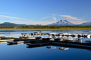
The Fall River in summer
USA Oregon location map.svg
Red pog.svg
Location of the mouth of the Fall River in Oregon
CountryUnited States
StateOregon
County Deschutes
Physical characteristics
SourceDeschutes National Forest [1]
 - locationa spring about 3.8 mi (6.1 km) southeast of Lookout Mountain [2]
 - coordinates 43°46′03″N121°38′00″W / 43.76750°N 121.63333°W / 43.76750; -121.63333 [3]
 - elevation4,274 ft (1,303 m) [4]
River mouth Deschutes River (left bank)
 - locationjust downstream from La Pine State Park
 - coordinates 43°47′18″N121°30′41″W / 43.78833°N 121.51139°W / 43.78833; -121.51139 Coordinates: 43°47′18″N121°30′41″W / 43.78833°N 121.51139°W / 43.78833; -121.51139 [3]
 - elevation4,175 ft (1,273 m) [4]
Length12 mi (19 km) [5]

The Fall River is a tributary of the Deschutes River [6] in the Deschutes National Forest in Deschutes County, Oregon, United States. [3] The source is a spring approximately 2 miles (3 km) northwest of Pringle Falls. The river flows to the northeast and is about 12 miles (19 km) long. [5] Fly fishing is permitted.

Deschutes River (Oregon) river in the United States of America

The Deschutes River in central Oregon is a major tributary of the Columbia River. The river provides much of the drainage on the eastern side of the Cascade Range in Oregon, gathering many of the tributaries that descend from the drier, eastern flank of the mountains. The Deschutes provided an important route to and from the Columbia for Native Americans for thousands of years, and then in the 19th century for pioneers on the Oregon Trail. The river flows mostly through rugged and arid country, and its valley provides a cultural heart for central Oregon. Today the river supplies water for irrigation and is popular in the summer for whitewater rafting and fishing.

Deschutes National Forest United States National Forest in Oregon

The Deschutes National Forest is a United States National Forest located in parts of Deschutes, Klamath, Lake, and Jefferson counties in central Oregon. It comprises 1.8 million acres (7,300 km2) along the east side of the Cascade Range. In 1908, the Deschutes National Forest was established from parts of the Blue Mountains, Cascade, and Fremont National Forests. In 1911, parts of the Deschutes National Forest were split off to form the Ochoco and Paulina National Forests, and parts of the Cascade and Oregon National Forests were added to the Deschutes. In 1915, the lands of the Paulina National Forest were rejoined to the Deschutes National Forest. A 1993 Forest Service study estimated that the extent of old growth in the forest was 348,100 acres (140,900 ha). Within the boundaries of the Deschutes National Forest is the Newberry National Volcanic Monument, containing cinder cones, lava flows, and lava tubes. The Deschutes National Forest as a whole contains in excess of 250 known caves. The forest also contains five wilderness areas, six National Wild and Scenic Rivers, the Oregon Cascade Recreation Area, and the Metolius Conservation Area. Forest headquarters are located in Bend, Oregon. There are local ranger district offices in Bend, Crescent, and Sisters.

Deschutes County, Oregon County in the United States

Deschutes County is a county in the U.S. state of Oregon. As of the 2010 census, the population was 157,733. The county seat is Bend. The county was created in 1916 out of part of Crook County and was named for the Deschutes River, which itself was named by French-Canadian trappers of the early 19th century. It is the political and economic hub of Central Oregon.

Contents

There is a trail along the river, and also a campground about one mile downstream from the head of the river; a guard station at the head of the river can be rented. [7] [8]

Fall River Falls is on the river within La Pine State Park. [9]

La Pine State Park

La Pine State Park is a state park along the Deschutes River in the U.S. state of Oregon, administered by the Oregon Parks and Recreation Department.

The Fall River also hosts the Fall River Hatchery, a state-run fish hatchery which raises rainbow trout, brook trout and cutthroat trout fingerling for stocking programs throughout the state. [10] The river has one named tributary, Indian Creek, which enters from the left above the hatchery. [11]

Fish hatchery place for artificial breeding, hatching and rearing through the early life stages of fish

A fish hatchery is a place for artificial breeding, hatching, and rearing through the early life stages of animals—finfish and shellfish in particular. Hatcheries produce larval and juvenile fish, shellfish, and crustaceans, primarily to support the aquaculture industry where they are transferred to on-growing systems, such as fish farms, to reach harvest size. Some species that are commonly raised in hatcheries include Pacific oysters, shrimp, Indian prawns, salmon, tilapia and scallops. The value of global aquaculture production is estimated to be US$98.4 billion in 2008 with China significantly dominating the market; however, the value of aquaculture hatchery and nursery production has yet to be estimated. Additional hatchery production for small-scale domestic uses, which is particularly prevalent in South-East Asia or for conservation programmes, has also yet to be quantified.

Rainbow trout species of trout

The rainbow trout is a trout and species of salmonid native to cold-water tributaries of the Pacific Ocean in Asia and North America. The steelhead is an anadromous (sea-run) form of the coastal rainbow trout(O. m. irideus) or Columbia River redband trout (O. m. gairdneri) that usually returns to fresh water to spawn after living two to three years in the ocean. Freshwater forms that have been introduced into the Great Lakes and migrate into tributaries to spawn are also called steelhead.

Brook trout species of fish

The brook trout is a species of freshwater fish in the char genus Salvelinus of the salmon family Salmonidae. It is native to Eastern North America in the United States and Canada, but has been introduced elsewhere in North America, as well as to Iceland, Europe, and Asia. In parts of its range, it is also known as the eastern brook trout, speckled trout, brook charr, squaretail, or mud trout, among others. A potamodromous population in Lake Superior, as well as an anadromous population in Maine, is known as coaster trout or, simply, as coasters. The brook trout is the state fish of nine U.S. states: Michigan, New Hampshire, New Jersey, New York, North Carolina, Pennsylvania, Vermont, Virginia, and West Virginia, and the Provincial Fish of Nova Scotia in Canada.

See also

Related Research Articles

White River (Oregon) river in the United States of America

The White River is a tributary of the Deschutes River, approximately 50 miles (80 km) long, in north-central Oregon in the United States. It drains a scenic mountainous area of the Columbia Plateau on the east side of the Cascade Range southeast of Mount Hood. In the 1840s, a section of the Oregon Trail called the Barlow Road passed through the river corridor. This section of the road is listed on the National Register of Historic Places.

Metolius River river in the United States of America

The Metolius River is a tributary of the Deschutes River in Central Oregon, United States, near the city of Sisters. The river flows north from springs near Black Butte, then turns sharply east, descending through a series of gorges before ending in the western end of the lake. The unincorporated community of Camp Sherman lies astride the southern end of the river. The name of the river comes from the Warm Springs or Sahaptin word mitula, meaning white salmon and referring to a light colored Chinook salmon and not a whitefish.

Cultus Lake (Oregon) lake in United States of America

Cultus Lake is a natural lake in Deschutes County in the U.S. state of Oregon. Formed by a glacier, it is located in the high Cascade Range in the Deschutes National Forest. The name is from the Chinook Jargon and means variously bad or worthless, or simply "in vain".

Crooked River (Oregon) tributary of the Deschutes River in the U.S. state of Oregon

The Crooked River is a tributary, 125 miles (201 km) long, of the Deschutes River in the U.S. state of Oregon. The river begins at the confluence of the South Fork Crooked River and Beaver Creek. Of the two tributaries, the South Fork Crooked River is the larger and is sometimes considered part of the Crooked River proper. A variant name of the South Fork Crooked River is simply "Crooked River". The Deschutes River flows north into the Columbia River.

Chewaucan River river in the United States of America

The Chewaucan River is part of the Great Basin drainage. It flows 53 miles (85 km) through the Fremont–Winema National Forests, Bureau of Land Management land, and private property in southern Oregon. Its watershed consists of 651 square miles (1,690 km2) of conifer forest, marsh, and rural pasture land. The river provides habitat for many species of wildlife including native Great Basin redband trout a subspecies of rainbow trout.

Salt Creek Falls waterfall

Salt Creek Falls is a cascade and plunge waterfall on Salt Creek, a tributary of the Middle Fork Willamette River, that plunges into a gaping canyon near Willamette Pass in the Willamette National Forest, near Oakridge, Oregon. The waterfall is notable for its main drop of 286 feet (87 m) which makes it the third highest plunge waterfall in Oregon after Multnomah Falls and Watson Falls the second highest, which was re-measured in 2009 and found to be 293 feet rather than an earlier measurement of 272 feet passing Salt Creek Falls. The pool at the bottom of the waterfall is 20 metres (66 ft) deep.

Wickiup Reservoir

Wickiup Reservoir is the second-largest reservoir in the U.S. state of Oregon. It is located 60 miles (97 km) southwest of Bend, and is the largest of the Cascade Lakes. Wickiup Reservoir is close to the Twin Lakes, Davis Lake, Crane Prairie Reservoir, Cultus Lake, and Little Cultus Lake. The reservoir is located within the Deschutes National Forest and the Fort Rock Ranger District, near the Cascade Lakes Scenic Byway.

Trout Creek (Deschutes River) river in United States of America

Trout Creek is a 51-mile (82 km) long tributary of the Deschutes River in the U.S. state of Oregon. It drains approximately 692 square miles (1,792 km2) of Crook, Jefferson, and Wasco counties. Arising in the Ochoco Mountains, it flows north and then west to its confluence with the Deschutes River.

Crane Prairie Reservoir

Crane Prairie Reservoir is a man-made lake located about 42 miles (68 km) southwest of Bend in Deschutes County, Oregon, United States. The reservoir is named for the cranes that thrive in its habitat and for the upper Deschutes River prairie that once covered the area before the dam on the Deschutes was constructed in 1922. Eighteen years later, in 1940, the dam was rebuilt by the Bureau of Reclamation. The reservoir now serves as one of Oregon's largest rainbow trout fisheries. The heaviest fish ever caught in the lake was a 19-pound (8.6 kg) trout.

West Fork Millicoma River river in the United States of America

The West Fork Millicoma River is a tributary, about 34 miles (55 km) long, of the Millicoma River in the U.S. state of Oregon. Rising in northeastern Coos County near the Douglas County line, it flows generally southwest through the Elliott State Forest of the Southern Oregon Coast Range to the community of Allegany. There it joins the East Fork Millicoma River to form the Millicoma. In turn, the Millicoma, which is only about 9 miles (14 km) long, joins the South Fork Coos River to form the Coos River. The Coos River, itself only about 5 miles (8 km) long, empties into the eastern end of Coos Bay, which connects to the Pacific Ocean.

Salt Creek (Middle Fork Willamette River tributary) river in the United States of America

Salt Creek is a tributary, 30 miles (48 km) long, of the Middle Fork Willamette River in Lane County in the U.S. state of Oregon. It is named for salt springs along its banks that are used as licks by deer. The stream originates as an outflow of Lower Betty Lake in the forested Cascade Range just southeast of Waldo Lake. From its source, Salt Creek flows generally south, through Gold Lake, to Route 58, which it then follows mainly northwest for about 26 miles (42 km) to its mouth at the Middle Fork Willamette River just below Hills Creek Dam. At Salt Creek Falls—roughly 4 miles (6.4 km) west of Willamette Pass and a little more than 22 miles (35 km) upstream from the mouth—the stream plunges 286 feet (87 m), discharging an average of 50,000 U.S. gallons (190,000 L) of water per minute, or 111 cubic feet per second (3.1 m3/s). Below the falls, the creek enters a narrow canyon shaped by glaciation and basalt lava flows from higher in the Cascades. McCredie Hot Springs, at the former community of McCredie Springs, are natural hot springs along the lower half of Salt Creek beside Route 58.

North Fork Alsea River river in the United States of America

The North Fork Alsea River is a 16-mile (26 km) tributary of the Alsea River in the U.S. state of Oregon. It begins at Klickitat Lake, fed by Klickitat and Lake creeks in the Central Oregon Coast Range, and flows generally south to near Alsea, where it joins the South Fork Alsea River to form the main stem. For most of its course, the North Fork winds through the Siuslaw National Forest in Lincoln County and then Benton County. It passes under Oregon Route 34 northeast of Alsea.

Roaring River (Crabtree Creek) river in Linn County, United States of America

Roaring River is a tributary of Crabtree Creek in Linn County in the U.S. state of Oregon. It begins in the western foothills of the Cascade Range near Snow Peak. From there it flows generally west to meet Crabtree Creek at Larwood Wayside Park, north of Lacomb, about 16 miles (26 km) upstream of where the creek meets the South Santiam River east of Albany. The only named tributary of Roaring River is Milky Fork, which enters from the left near Roaring River Park.

North Fork Smith River (Umpqua River tributary) river in the United States of America

The North Fork Smith River is a 34-mile (55 km) tributary of the Smith River in Douglas County in the U.S. state of Oregon. It begins in the Central Oregon Coast Range near Roman Nose Mountain and flows generally southwest to meet the larger river 16 miles (26 km) from its confluence with the Umpqua River at Reedsport. The entire course of the North Fork lies within the Siuslaw National Forest.

Spring River (Deschutes River tributary)

The Spring River is a tributary, only about 1 mile (1.6 km) long, of the Deschutes River in Deschutes County in the U.S. state of Oregon. Arising near Anns Butte, it flows generally northeast into the Deschutes at Sunriver, about 190 miles (310 km) from the larger stream's confluence with the Columbia River. The Spring River has no named tributaries.

Drift Creek (Siletz Bay) river in the United States of America

Drift Creek is a tributary, about 18 miles (29 km) long, of Siletz Bay in the U.S. state of Oregon. The creek begins near Stott Mountain in the Central Oregon Coast Range in Lincoln County and follows a winding course generally west through the Siuslaw National Forest to enter the bay south of Lincoln City on the Pacific Ocean. It passes under U.S. Route 101 just before reaching the bay.

Fall Creek (Middle Fork Willamette River)

Fall Creek is a 34-mile (55 km) tributary of the Middle Fork Willamette River in Lane County in the U.S. state of Oregon. Beginning in the Cascade Range, the creek flows generally west through the Willamette National Forest to enter the Middle Fork upstream of Jasper, southeast of Springfield and Eugene.

Coldwater Lake (Washington) lake of the United States of America

Coldwater Lake is a barrier lake on the border of Cowlitz County and Skamania County, Washington in the United States. The lake was created during the 1980 eruption of Mount St. Helens, which blocked its natural outlet, Coldwater Creek, with volcanic debris. It is one of several lakes in the area that were created or otherwise enlarged by the eruption.

References

  1. Round Mountain Quadrangle, Oregon (PDF) (Map). 1:24,000. 7.5-Minute Series (Topographic). Cartography by U.S. Forest Service. 21 March 2012. Retrieved 13 September 2014.
  2. The National Map 2.0 (Map). Cartography by U.S. Geological Survey. Retrieved 13 September 2014.
  3. 1 2 3 "Fall River". Geographic Names Information System . United States Geological Survey. 28 November 1980. Retrieved 13 September 2014.
  4. 1 2 Source and mouth elevations derived from Google Earth search using GNIS coordinates.
  5. 1 2 "Fall River Hatchery". The ODFW Visitors' Guide. Oregon Department of Fish and Wildlife. Retrieved 13 September 2014.
  6. "Fall River". U.S. Forest Service. Retrieved 11 September 2014.
  7. "Fall River Guard Station". Recreation.gov. Retrieved 11 September 2014.
  8. "Fall River Trail". Alltrails.com. Retrieved 11 September 2014.
  9. "Fall River Falls". Northwest Waterfall Survey. Retrieved 11 September 2014.
  10. "Fall River Hatchery". Oregon Department of Fish and Wildlife. Retrieved 11 September 2014.
  11. "United States Topographic Map". United States Geological Survey. Retrieved February 15, 2016 via Acme Mapper.