
The Mississippi River is a tributary of the Ottawa River in Eastern Ontario, Canada which has no relation with the Mississippi River in the United States. It is 200 kilometres (120 mi) in length from its source at Mackavoy Lake, has a drainage area of 4,450 square kilometres (1,720 sq mi), and has a mean discharge of 40 cubic metres per second (1,400 cu ft/s). There are more than 250 lakes in the watershed.
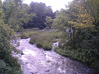
The Indian River is a river in Lanark County in Eastern Ontario, Canada. It is in the Saint Lawrence River drainage basin and is a left tributary of the Mississippi River.

Lanark County is a county located in the Canadian province of Ontario. Its county seat is Perth, which was first settled in 1816. Most European settlements of the county began in 1816, when Drummond, Beckwith and Bathurst townships were named and initially surveyed. The first farm north of the Rideau was cleared and settled somewhat earlier, in 1790. The county took its name from the town of Lanark in Scotland. Nearly all the townships were named after British public and military figures from the era of early settlement.
The Moira River is a river in Hastings County in eastern Ontario, Canada. It travels from its source in the centre of the county to the Bay of Quinte at the county seat Belleville.

The Jock River, known locally as the Mighty Jock, is a river in Ottawa and Lanark County in Eastern Ontario, Canada. It is in the Saint Lawrence River drainage basin and is a left tributary of the Rideau River. The river is named after Jacques, a French man who drowned in it in the early 19th century, and it was once known as the Goodwood River. The River is supported by a community-volunteer organization known as the Friends of the Jock River.

The Tay River is a river in Lanark County in Eastern Ontario, Canada. It is in the Saint Lawrence River drainage basin and is a left tributary of the Rideau River.
The Clyde River is a river in Lanark County in Eastern Ontario, Canada. It is in the Saint Lawrence River drainage basin, is a left tributary of the Mississippi River, and was named after the River Clyde in Scotland.

Sharbot Lake is a suburban community and unincorporated area in the municipality of Central Frontenac, Frontenac County in Eastern Ontario, Canada. Named after the Sharbot family, who were local residents, it appeared in Lovell's Gazetteer in 1874. It is part of the Land O'Lakes Tourist Region and is located on the eponymous Sharbot Lake.
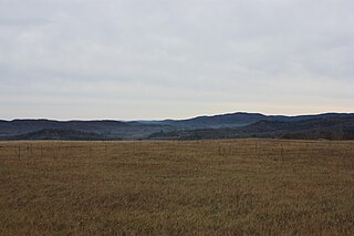
The Opeongo Hills are a range of hills in Southern Ontario, near Algonquin Provincial Park. The hills stretch from Opeongo Lake in Algonquin Park in the west, along the Madawaska and Opeongo Rivers, towards the Opeongo Colonization Road, and extending towards the Deacon Escarpment, Bonnechere, Ontario, and Dacre in the east. To the east of the Opeongo Hills lie the Madawaska River valley, the Mississippi River Valley, and the Ottawa-Bonnechere Graben along the Ottawa River. The hills continue into Quebec across the Ottawa River as the Laurentian Highlands and the Laurentian Mountains. Its tallest peak is roughly 7 km northeast of Highway 60. At roughly 586 meters, it is the tallest point in Southern Ontario. The community of Foymount is one of the highest settlements in Southern Ontario.

The K&P Trail is a recreational trail that runs along the old Kingston and Pembroke Railway (K&P) bed in Ontario, Canada. The K&P was abandoned by its owner, Canadian Pacific Railway, between 1962 and 1986, and ran from Kingston to Renfrew.

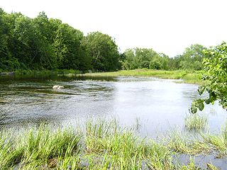
Mississippi Lake is a lake in Lanark County in Ontario, Canada. Ontario's Mississippi River flows northeast and north through the lake. Several small creeks including Cranberry Creek, McCrearys Creek, and McGibbon Creek drain into the lake from adjoining forest and agricultural land. The lake is distinctive for having one side that is part of the Canadian shield, while the other is mostly limestone. The lake is a remnant of the old Champlain Sea, which flooded eastern Ontario at the end of last ice age. The former shoreline of the sea can still be traced inland from the north shore of the lake.
King's Highway 38, commonly referred to as Highway 38, was a provincially maintained highway in the Canadian province of Ontario. The 66.9-kilometre (41.6 mi) road connected Highway 2 and Highway 401 in Kingston with Highway 7 west of Perth. It was designated in 1934 and remained relatively unchanged throughout its existence, aside from some minor diversions and a rerouting through Kingston as a result of the construction of Highway 401 in the mid-1950s. At the beginning of 1998, the entire highway was transferred to the municipalities of Frontenac County through which it travelled: Kingston, South Frontenac and Central Frontenac. Today the former highway is named Road 38 and Gardiners Road, but is still referred to as Highway 38 by locals.
Bolton Lakes is a lake in the Ottawa River drainage basin in Central Frontenac, Frontenac County, Ontario, Canada. It is about 5.2 kilometres (3.2 mi) long and 0.5 kilometres (0.3 mi) wide, and lies at an elevation of 214 metres (702 ft), 7.5 kilometres (4.7 mi) northwest of the community of Sharbot Lake and 3.5 kilometres (2.2 mi) north of Highway 7. The primary outflow is Bolton Creek, which flows via the Fall River, and then the Mississippi River into the Ottawa River.
Peterson Creek is a river in the Ottawa River drainage basin in Lanark Highlands, Lanark County and North Frontenac, Frontenac County in eastern Ontario, Canada. It flows 9.5 kilometres (5.9 mi) from and unnamed lake to its mouth at the South Branch Clyde River.
Peterson Creek is a river in the Lake Ontario and Cataraqui River drainage basins in South Frontenac, Frontenac County and Rideau Lakes, Leeds and Grenville United Counties in eastern Ontario, Canada. It flows 6.5 kilometres (4.0 mi) from Upper Peterson Lake to its mouth at Hart Lake.
Bobs Lake is a lake in Frontenac County and Lanark County in Eastern Ontario, Canada. It is in the St. Lawrence River drainage basin and is the source of the Tay River.
Black Lake is a lake in the municipality of Central Frontenac, Frontenac County in Eastern Ontario, Canada. It is part of the Saint Lawrence River drainage basin.
Sharbot Lake is a lake in the municipality of Central Frontenac, Frontenac County in Eastern Ontario, Canada. It is part of the Saint Lawrence River drainage basin. The eponymous community of Sharbot Lake is located at the centre of the north shore of the lake.

Silver Lake is a lake in Tay Valley, Lanark County, and Central Frontenac, Frontenac County, in Eastern Ontario, Canada. It is the source of Silver Lake Creek and is in the Ottawa River drainage basin.
Wesleys Creek is a stream in Central Frontenac, Frontenac County, and Tay Valley, Lanark County in Eastern Ontario, Canada. It flows to Silver Lake and is in the Ottawa River drainage basin.
