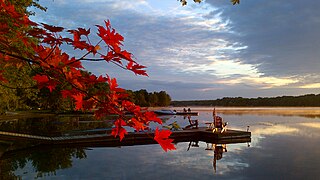
The Barron River is a river in the Saint Lawrence River drainage basin in Nipissing District and Renfrew County, Ontario, Canada. It flows from Clemow Lake in northern Algonquin Provincial Park and joins the Petawawa River, whose southern branch it forms, in the municipality of Laurentian Hills, near the municipality of Petawawa.
Cleaver Lake is a lake in the Unorganized West Part of Timiskaming District in Northeastern Ontario, Canada. It is about 800 metres (2,600 ft) long and 150 metres (490 ft) wide, and lies at an elevation of 329 metres (1,079 ft) about 16 kilometres (10 mi) northwest of the community of Gowganda and about 21.7 kilometres (13.5 mi) southwest of Matachewan. The primary inflow and outflow is Cleaver Creek, which flows into the West Montreal River, a tributary of the Montreal River and part of the Ottawa River system.
Drive Lake is a lake in the Nelson River drainage basin in the Unorganized Part of Kenora District in northwestern Ontario, Canada. It is about 1,250 metres (4,101 ft) long and 490 metres (1,608 ft) wide, lies at an elevation of 394 metres (1,293 ft), and is 1 kilometre (0.6 mi) north of Highway 516. Drive Lake is the source of Drive Creek; the creek leaves the lake at its eastern tip and flows into the Marchington River.

Shadow Lake is a lake in the city of Kawartha Lakes in Central Ontario, Canada. With an area of 356.8 hectares and an elevation of 259 metres (850 ft), it is the second lake upstream of the mouth of the Gull River, and is in the Lake Ontario drainage basin.
McKenzie Lake is a lake in South Algonquin, Nipissing District and Hastings Highlands, Hastings County in Ontario, Canada. It is in the Saint Lawrence River drainage basin, is part of the Madawaska River river system, and lies about 14 kilometres (9 mi) south of the community of Madawaska and a similar distance north of the small town of Maynooth. The settlement of McKenzie Lake is on the north shore of the lake.
Frith Lake is lake in geographic Churchill Township the Unorganized North Part of Sudbury District in northeastern Ontario, Canada. The lake is in the Saint Lawrence River drainage basin.
Big Straggle Lake is a lake in the municipality of Dysart et al, Haliburton County in Central Ontario, Canada. It lies at an elevation of 411 metres (1,348 ft), has an area of 96.5 hectares, and is in the Ottawa River drainage basin.
Little Straggle Lake is a lake in the municipality of Dysart et al, Haliburton County in Central Ontario, Canada. It lies at an elevation of 411 metres (1,348 ft), has an area of 38.3 hectares, and is in the Ottawa River drainage basin.

Silver Lake is a lake in Tay Valley, Lanark County, and Central Frontenac, Frontenac County, in Eastern Ontario, Canada. It is the source of Silver Lake Creek and is in the Ottawa River drainage basin.
Wesleys Creek is a stream in Central Frontenac, Frontenac County, and Tay Valley, Lanark County in Eastern Ontario, Canada. It flows to Silver Lake and is in the Ottawa River drainage basin.
Straggle Creek is a stream in the municipality of Dysart et al, Haliburton County in Central Ontario, Canada. It is a right tributary of Allen Creek and is in the Ottawa River drainage basin.
Allen Creek is a stream in the municipality of Dysart et al, Haliburton County in Central Ontario, Canada. It is a tributary of Benoir Lake and is in the Ottawa River drainage basin.
Little Allen Lake is a lake in the municipality of Dysart et al, Haliburton County in Central Ontario, Canada. It is the source of Allen Creek and is in the Ottawa River drainage basin.
Allen Lake is a lake in the municipality of Dysart et al, Haliburton County in Central Ontario, Canada. It is on Allen Creek and is in the Ottawa River drainage basin.
Fishtail Lake is a lake in the municipality of Dysart et al, Haliburton County in Central Ontario, Canada. It is on Allen Creek and is in the Ottawa River drainage basin.
Luke Lake is a small lake in the municipality of Dysart et al, Haliburton County in Central Ontario, Canada. It is in the Ottawa River drainage basin.
Kennaway Lake is a small lake in the municipality of Dysart et al, Haliburton County in Central Ontario, Canada. It is in the Ottawa River drainage basin.
Weepine Lake is a small lake in the municipality of Dysart et al, Haliburton County in Central Ontario, Canada. It is within Algonquin Provincial Park and is part of the Ottawa River drainage basin.
Fourcorner Lake is a lake in the municipality of Dysart et al, Haliburton County in Central Ontario, Canada. It is partly within Algonquin Provincial Park and is in the Ottawa River drainage basin. The lake takes its name from its location at a quadripoint, the junction point of four geographic townships: Harburn at northwest, Bruton at the northeast, Harcourt at the southeast, and Dudley at the southwest.
Potter Creek is a stream in the Unorganized South Part of Nipissing District in Northeastern Ontario, Canada. It is a tributary of Canoe Lake, is in the Lake Huron drainage basin, and lies within Algonquin Provincial Park.


