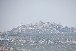
"}" id="mwBA">
Far'ata | |
---|---|
Arabic transcription(s) | |
• Arabic | فرعتا |
• Latin | Far'ata (unofficial) |
Far'ata | |
Location of Fara'ata within Palestine | |
Coordinates: 32°11′26″N35°09′57″E / 32.19056°N 35.16583°E | |
Palestine grid | 165/177 |
State | State of Palestine |
Governorate | Qalqilya |
Government | |
• Type | Local Development Committee |
Elevation | 432−518 m (−1,267 ft) |
Population (2017) [2] | |
• Total | 872 |
Name meaning | Ferata, p.n. [3] |
Far'ata (Arabic : فرعتا) was a Palestinian village in the Qalqilya Governorate in the Western area of the West Bank, located 16 kilometers Southwest of Nablus. According to the Palestinian Central Bureau of Statistics, the village had a population of 872 inhabitants in 2017. [2]
In 2012 Fara'ata was merged with the larger Immatain village council. [1]
Immatin and Far’ata are located 19 kilometers (12 mi) west of Qalqiliya. They are bordered by Tell to the east, Deir Istiya to the south, Jinsafut, Al Funduq and Hajjah to the west, and Kafr Qaddum and Jit to the north. [1]
Byzantine ceramics have been found in the village. [4]
Fara'ata was noted in the Samaritan Chronicle (from the 12th century) under the name of Ophrah, while it has been known under its present name since the 14th century. [5]
Far'ata was incorporated into the Ottoman Empire in 1517 with all of Palestine, and in 1596 it appeared in the tax registers as Fara'ta, being in the Nahiya of Jabal Qubal of the Liwa of Nablus. It had a population of 12 households and 6 bachelor, all Muslim. The villagers paid a fixed tax rate of 33,3% on a number of crops, including wheat, barley, summer crops, olive trees, goats and beehives, in addition to occasional revenues, a press for olive oil or grape syrup, and a fixed tax for people of Nablus area; a total of 4,500 Akçe. [6]
In 1838, Fer'ata was noted as located in Jurat Merda, south of Nablus. [7]
In 1870 the French explorer Victor Guérin visited Far'ata, which he described having "a very small number" of people, with some cisterns and remains of a stone sarcophagus as remnants of former history. [8]
In 1870/1871 (1288 AH), an Ottoman census listed the village with a population of 10 households in the nahiya (sub-district) of Jamma'in al-Awwal, subordinate to Nablus. [9]
In the PEF's Survey of Western Palestine (SWP) (1882), Far'ata was described as a "small village of ancient appearance, standing on a [..] mound, with a rock-cut tomb to the south, and a sacred Mukam to the east." [5]
In the 1922 census of Palestine conducted by the British Mandate authorities, Far'ata had a population of 36, all Muslim, [10] increasing in the 1931 census to of 47 Muslims, in a total of 11 houses. [11]
In the 1945 statistics the population of Far'ata was 70 Muslims, [12] while the total land area was 1,664 dunams, according to an official land and population survey. [13] Of this, 56 were allocated for plantations and irrigable land, 961 for cereals, [14] while 10 dunams were classified as built-up areas. [15]
In the wake of the 1948 Arab–Israeli War, and after the 1949 Armistice Agreements, Far'ata came under Jordanian rule.
The Jordanian census of 1961 found 317 inhabitants in Faraata. [16]
Since the Six-Day War in 1967, Far'ata has been held under Israeli occupation.
After the 1995 accords, 58.3% of the total village land of Immatain/Far'ata was assigned as Area B land, while the remaining 41.7% is Area C land. [17]
In 2010, Far'ata was described by Gideon Levy as one of the Palestinian villages where the people "live in terror of the settlers and their accursed 'Price tag,' and nobody came to their defense". [18]
Immatin is a Palestinian village located in the northwestern West Bank, in the Qalqilya Governorate of the State of Palestine, about seventeen kilometers southwest of Nablus. The current mayor of Immatin is Haythem Sawan.
Kafr Thulth is a Palestinian town located on high, flat land south of Azzoun, 28 kilometers (17 mi) south of Tulkarm in the Qalqilya Governorate. The average elevation is 270 meters (890 ft) above sea level. According to the Palestinian Central Bureau of Statistics, the town's population was 5,606 in the 2017 census.
'Aqqaba is a Palestinian town located on a slope in the Jordan Valley in the northern West Bank, 15 kilometers northeast of Jenin in the Tubas Governorate of the State of Palestine. According to the Palestinian Central Bureau of Statistics (PCBS), the town had a population of 8,239 inhabitants in the 2017 census.
Tell, pronounced Till, is a Palestinian town in the Nablus Governorate in northern West Bank, located five kilometers southwest of Nablus. According to the Palestinian Central Bureau of Statistics (PCBS), the town had a population of 5,162 inhabitants in 2017. Most of the town's laborers work in agriculture, with figs and olives being the major source of income.
Duma is a Palestinian town in the Nablus Governorate in the northern West Bank, located 25 kilometers southeast of Nablus. According to the Palestinian Central Bureau of Statistics, the town had a population of 2,674 inhabitants in 2017. Duma's total land area consists of 17,351 dunams, about 200 of which are designated as built-up area.
Qabalan is a Palestinian town in the Nablus Governorate in the eastern West Bank, located 19 kilometers (12 mi) southeast of Nablus. According to the Palestinian Central Bureau of Statistics (PCBS), the town had a population of 8,195 inhabitants in 2017.
Al-Attara is a Palestinian village in the Jenin Governorate of Palestine, in the northwestern area of the West Bank, located 15 kilometers southwest of Jenin. According to the Palestinian Central Bureau of Statistics, the village had a population of 1,072 inhabitants in mid-year 2006 and 1,244 by 2017.
Haris is a Palestinian town in the Salfit Governorate of the State of Palestine, in the northern West Bank, 24 kilometers Southwest of Nablus. According to the Palestinian Central Bureau of Statistics, it had a population of 4,137 in 2017.
Iskaka is a Palestinian town in the Salfit Governorate of the State of Palestine, in the northern West Bank, 27 kilometers southwest of Nablus. According to the Palestinian Central Bureau of Statistics, it had a population of 1,198 in 2017.
Sarta is a Palestinian town in the Salfit Governorate in the northern West Bank, 22 kilometers southwest of Nablus. According to the Palestinian Central Bureau of Statistics, it had a population of approximately 3,382 in 2017.
Deir Sharaf is a Palestinian town in the Nablus Governorate of the State of Palestine, in the northern West Bank, located northwest of Nablus. According to the Palestinian Central Bureau of Statistics (PCBS), the town had a population of 2,949 inhabitants in 2017.
Jurish is a Palestinian town in Nablus Governorate in the northern West Bank, located 27 kilometers southeast of Nablus. According to the Palestinian Central Bureau of Statistics (PCBS), the town had a population of 1,541 inhabitants in 2017.
Kafr Qallil is a Palestinian town in the Nablus Governorate of the State of Palestine, in the northern West Bank. According to the Palestinian Central Bureau of Statistics (PCBS), the town had a population of 3,029 inhabitants in 2017.
Majdal Bani Fadil is a Palestinian village in the Nablus Governorate of the northern West Bank, located 23 kilometers (14 mi) southeast of Nablus. According to the Palestinian Central Bureau of Statistics (PCBS), the town had a population of 2,907 in 2017. Majdal Bani Fadil is under the administration of a nine-member village council headed by Walid Othman. The main economic activities are herding and agriculture, specifically olives, grapes, prunes and figs. The main road connecting Majdal Bani Fadil to Ramallah and Nablus and Jericho has been closed off to the village since 2000 during the Second Intifada.
Qusin is a Palestinian town in the Nablus Governorate in northern West Bank, located 8 kilometers West of Nablus. According to the Palestinian Central Bureau of Statistics (PCBS), the town had a population of 2,251 inhabitants in 2017.
Sarra is a Palestinian town in the Nablus Governorate in northern West Bank, located 11 kilometers southwest of Nablus. According to the Palestinian Central Bureau of Statistics (PCBS), the town had a population of 3,384 inhabitants in 2017.
Yatma is a Palestinian town in the Nablus Governorate in northern West Bank, located 15 kilometers south of Nablus. According to the Palestinian Central Bureau of Statistics (PCBS), the town had a population of 3,363 inhabitants in 2017.
Zeita Jamma'in is a Palestinian village in the Nablus Governorate in northern West Bank, located 16 kilometers southwest of Nablus. The village is located just north of Jamma'in, from which the village receives its name. According to the Palestinian Central Bureau of Statistics (PCBS), Zeita Jamma'in had a population of 2,740 inhabitants in 2017.
Kufeirit is a Palestinian village in the West Bank, located 16 km west of the city of Jenin in the northern West Bank. According to the Palestinian Central Bureau of Statistics, the town had a population of 2,446 inhabitants in mid-year 2006 and 3,068 by 2017.
Khirbat Qais is a Palestinian village in the Salfit Governorate in the northern West Bank. In 2010 it became a suburb of Salfit, about 4 km south of Salfit.