Fashoda State

Last updated
Fashoda State
Western Nile in South Sudan 2015.svg
Location of Fashoda in South Sudan
Country South Sudan
Capital Kodok [1]
Number of Counties3 [2]
Population
 (2014 Estimate)
  Total155,602

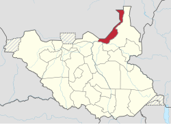
Fashoda State (previously named Western Nile State) was a state in South Sudan that existed between 2 October 2015 and 22 February 2020. [3] It was located in the Greater Upper Nile region of South Sudan, and it bordered the country of Sudan to the north, and the southern Sudanese states of Eastern Nile to the east, Western Bieh to the southwest, and Ruweng to the west. [4]

Contents

History

Before the state was formed, the territory was part of the former state of Upper Nile. On 2 October 2015, President Salva Kiir issued a decree establishing 28 states in place of the 10 constitutionally established states. [5] The decree established the new states largely along ethnic lines. A number of opposition parties and civil society groups challenged the constitutionality of the decree. Kiir later resolved to take it to parliament for approval as a constitutional amendment. [6] In November the South Sudanese parliament empowered President Kiir to create new states. [7]

William Othuon was appointed Governor on 24 December 2015. [8]

Geography

The Western Nile State was part of the Greater Upper Nile region of South Sudan. The state shared borders with Sudan to the north, and the states of Eastern Nile to the east, Western Bieh to the southwest, and Ruweng to the west. [4]

Administrative divisions

When the state of Western Nile was formed, a total of three administrative divisions compromised the state. The counties that were compromised were Kodok County, Manyo County, and Panyikang County. [2]

Population and Towns

The town of Kodok was the most populous population cluster in the state. The population of the town in 2012 was placed at 7,709. The town of Kodok was also the capital of the state. [1]

Related Research Articles

<span class="mw-page-title-main">States of South Sudan</span> First-level administrative division of South Sudan

The States of South Sudan were created out of the three historic former provinces of Bahr el Ghazal (northwest), Equatoria (southern), and Greater Upper Nile (northeast). The states are further divided into 79 counties.

<span class="mw-page-title-main">Aweil State</span> State of South Sudan from 2015 to 2020

Aweil State was a state in South Sudan that existed between 2 October 2015 and 22 February 2020. It was located in the Bahr el Ghazal region and it borders Gogrial to the east, Lol to the west, Aweil East to the north, and Wau to the south. Its capital and largest city was Aweil.

<span class="mw-page-title-main">Aweil East State</span> State of South Sudan from 2015 to 2020

Aweil East also known as Abiem, was a state in South Sudan that existed between 2 October 2015 and 22 February 2020. It had an estimated population of 571,728 people and an area of 6,172.23 KM square. It was located in northern-western South Sudan. Its capital and largest city was Wanyjok. The state is located in the Bahr el Ghazal region and it bordered Twic State and Gogrial State to the east, Aweil State to the south, Lol State to the west, the disputed Abyei State region to the northeast, and Sudan to the north.

<span class="mw-page-title-main">Lol State</span> State in South Sudan from 2015 to 2020

The Lol State was a state of South Sudan with the capital in Raga, that existed between 2 October 2015 and 22 February 2020. It was located in the Bahr el Ghazal region, which is in the northwest section of the country. Lol state bordered Haut-Mbomou and Haute-Kotto in the Central African Republic to the west, South Darfur and East Darfur in Sudan to the north, the disputed region of Kafia Kingi to the northwest, Aweil East State to the northeast, Aweil State to the east, Gbudwe State to the south, and Wau State to the southeast. The state was created alongside 27 other states after a decree issuing the creation of 28 states took place. It was dissolved at the conclusion of the South Sudanese Civil War.

<span class="mw-page-title-main">Wau State</span> State of South Sudan from 2015 to 2020

Wau State was a state in South Sudan that existed between 2 October 2015 and 22 February 2020. It was located in the Bahr el Ghazal region, and was part of the former state of Western Bahr el Ghazal. Wau State bordered Aweil State, Gbudwe State, Gogrial State, Lol State, and Tonj State.

<span class="mw-page-title-main">Twic State</span> State of South Sudan from 2015 to 2020

Twic State was a state in South Sudan that existed between 2 October 2015 and 22 February 2020. It was located in the Bahr el Ghazal region and it bordered Aweil East to the west, the disputed Abyei region to the north, Gogrial to the south, Northern Liech to the east, and Ruweng to the northeast. The population of Twic State was recorded at 204,905 in 2008, and was estimated at a population of 543,410 in 2014. The capital of the state was Mayen-Abun, with an estimated population of around 2,000 people in city limits.

<span class="mw-page-title-main">Tonj State</span> State of South Sudan from 2015 to 2020

Tonj State was a state in South Sudan that existed between 2 October 2015 and 22 February 2020. It was located in the Bahr el Ghazal region and it bordered Wau to the west, Gbudwe to the southwest, Gogrial to the northwest, Northern Liech to the northeast, Gok and Southern Liech to the east, and Western Lakes to the south and east.

<span class="mw-page-title-main">Eastern Lakes State</span> State of South Sudan from 2015 to 2020

Eastern Lakes State was a state in South Sudan that existed between 2 October 2015 and 22 February 2020. It was located in the Bahr el Ghazal region and it bordered Southern Liech to the north, Western States to the west, Amadi to the southwest, Terekeka to the southeast, and Jonglei to the east.

<span class="mw-page-title-main">Western Lakes State</span> State of South Sudan from 2015 to 2020

Western Lakes was a state in South Sudan that existed between 2 October 2015 and 22 February 2020. It was located in the Bahr el Ghazal region and was part of the former state of Lakes State. It bordered Amadi State, Eastern Lakes State, Gbudwe State, Gok, Maridi State, Southern Liech State, and Tonj State.

<span class="mw-page-title-main">Terekeka State</span> State of South Sudan from 2015 to 2020

Terekeka State was a state in South Sudan that existed between 2 October 2015 and 22 February 2020. It was located in the Equatoria region and it bordered Amadi, Eastern Lakes, Imatong, Jonglei, and Jubek. It has an estimated population of 176,030 in 2014, and the capital and largest city of the state is Terekeka, South Sudan.

<span class="mw-page-title-main">Boma State</span> State of South Sudan from 2015 to 2020

Boma State was a state in South Sudan that existed between 2 October 2015 and 22 February 2020. It was located in the Greater Upper Nile region and was formerly part of the state of Jonglei. The state bordered Akobo State, Imatong State, Jonglei State, Kapoeta State, Bieh State, Terekeka State and the country of Ethiopia to the east.

<span class="mw-page-title-main">Bieh State</span> State of South Sudan from 2015 to 2020

Bieh State was a state in South Sudan that existed between 2 October 2015 and 22 February 2020. It was located in the Greater Upper Nile region and it bordered Fangak to the west, Central Upper Nile to the north, Latjoor and Akobo to the east, and Jonglei to the south.

<span class="mw-page-title-main">Latjoor State</span> State of South Sudan from 2015 to 2020

Latjoor was a state in South Sudan that existed between 2 October 2015 and 22 February 2020. It was located in the Greater Upper Nile region and it bordered Eastern Nile to the north, Eastern Bieh to the south, and Ethiopia to the east.

<span class="mw-page-title-main">Northern Liech State</span> State of South Sudan from 2015 to 2020

Northern Liech was a state in South Sudan that existed between 2 October 2015 and 22 February 2020. It was located in the Greater Upper Nile region and it bordered Ruweng to the north, Western Bieh to the east, Southern Liech to the south, Tonj to the south, and Gogrial and Twic to the west.

<span class="mw-page-title-main">Eastern Nile State</span> State of South Sudan from 2015 to 2017

Eastern Nile was a state in South Sudan that existed between 2 October 2015 and 14 January 2017 when it was divided into Central Upper Nile State and Northern Upper Nile State. It was located in the Greater Upper Nile region and it was part of the former states of Upper Nile and Jonglei. The state bordered the states of Eastern Bieh, Latjoor, Western Bieh, Fashoda State, and the country of Ethiopia to the east.

<span class="mw-page-title-main">Ruweng Administrative Area</span> Administrative area in South Sudan

The Ruweng Administrative Area is an administrative area in South Sudan. The area was known as Ruweng State between 2 October 2015 and 22 February 2020 when it was a state of South Sudan.

<span class="mw-page-title-main">Southern Liech State</span> State of South Sudan from 2015 to 2020

Southern Liech State was a state in South Sudan that existed between 2 October 2015 and 22 February 2020. It was located in the Greater Upper Nile region and it bordered Northern Liech to the north, Western Bieh to the east, Jonglei to the southeast, Eastern Lakes to the south, Western Lakes to the southwest, and Tonj to the west.

<span class="mw-page-title-main">Fangak State</span> State of South Sudan from 2015 to 2020

Fangak State was a state in South Sudan that existed between 2 October 2015 and 22 February 2020. It was located in the Greater Upper Nile region and it bordered Ruweng to the northwest, Western Nile to the northeast, Eastern Nile to the east, Eastern Bieh to the southeast, Jonglei to the south, Southern Liech to the southwest, and Northern Liech to the west.

The Tiger Faction New Forces was a Shilluk militia that took part in the South Sudanese Civil War with the aim of reversing the division of South Sudan into 28 states in order to restore the territory of the Shilluk Kingdom per its 1956 borders. Led by Yoanis Okiech, the TFNF originally split from the Sudan People's Liberation Army (SPLA) in late October 2015 and subsequently started an insurgency against the SPLM government. In course of 2016, however, it also came into conflict with SPLM-IO rebels, leading to inter-rebel fighting which resulted in Okiech's death and the group's destruction in January 2017.

This article lists events from the year 2019 in South Sudan

References

  1. 1 2 Atekdit, Ariik (13 February 2016). "Western Nile Governor Appoints State Cabinet". Gurtong. Retrieved 14 August 2016.
  2. 1 2 "Full list of Kiirs proposed new 28 states in S Sudan". Radio Tamazuj. 3 October 2015. Archived from the original on 5 March 2016. Retrieved 31 May 2017.
  3. Mutambo, Aggrey. "S. Sudan govt agrees to reduce states to 10 to maintain peace". The East African. Retrieved February 15, 2020.
  4. 1 2 Christian, Über. "Western Nile". south-sudan.biz. Retrieved 31 May 2017.
  5. "Kiir and Makuei want 28 states in S Sudan". Radio Tamazuj. 2 October 2015. Archived from the original on 5 July 2016. Retrieved 31 May 2017.
  6. "Kiir pressured into taking decree to parliament for approval". Radio Tamazuj. Juba. 14 October 2015. Archived from the original on 8 December 2015. Retrieved 1 June 2017.
  7. "South Sudan's Kiir appoints governors of 28 new states". Sudan Tribune. Juba. 24 December 2015. Retrieved 1 June 2017.
  8. "South Sudan's President appoints 28 Governors, defies peace agreement". South Sudan News Agency. 24 December 2015. Archived from the original on 24 March 2016. Retrieved 31 May 2017.