
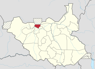
Western Bahr el Ghazal is a state in South Sudan. It has an area of 93,900 km2 (36,255 sq mi) and is the least populous state in South Sudan, according to the controversial Sudanese census conducted in 2008. It is part of the Bahr el Ghazal region. Its capital is Wau. The state shared international borders with Sudan to the north and the Central African Republic to the west. The portion now occupied by Raga County is the southern part of the historical region known as "Dar Fertit".

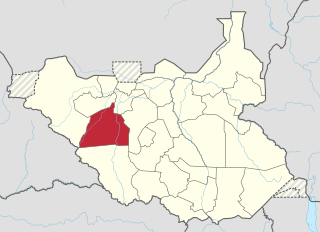
Northern Bahr el Ghazal(Arabic: ولاية شمال بحر الغزال) is a state in South Sudan. It has an area of 30,543 km2 and is part of the Bahr el Ghazal region. It borders East Darfur in Sudan to the north, Western Bahr el Ghazal to the west and south, and Warrap and the disputed region of Abyei to the east. Aweil is the capital of the state.

Wau is a city in northwestern South Sudan, on the western bank of the Jur River, that serves as capital for Western Bahr el Ghazal. It lies approximately 650 kilometres (400 mi) northwest of the capital Juba. A culturally, ethnically and linguistically diverse urban center and trading hub, Wau is also the former headquarters of Western Bahr el Ghazal.
Deim Zubeir, from the Arabic ديم الزبير ["Daim az-Zubayr"], commonly translated as the "Camp of Zubeir", is the historically established but highly controversial name of Uyujuku town in the Western Bahr el Ghazal of the Republic of South Sudan, located in the Western Bahr El Ghazal part of the country, some 70 km from the border with the Central African Republic (CAR), near the Biri tributary of the River Chel.

The States of South Sudan were created out of the three historic former provinces of Bahr el Ghazal (northwest), Equatoria (southern), and Greater Upper Nile (northeast). The states are further divided into 79 counties.
The Kuru River, or Chel River is a stream in the South Sudanese states of Western Bahr el Ghazal and Northern Bahr el Ghazal. It is a headwater of the Lol River.
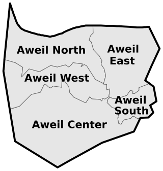
Aweil West County is an administrative area in Northern Bahr el Ghazal, South Sudan.

Aweil State was a state in South Sudan that existed between 2 October 2015 and 22 February 2020. It was located in the Bahr el Ghazal region and it borders Gogrial to the east, Lol to the west, Aweil East to the north, and Wau to the south. Its capital and largest city was Aweil.

Aweil East also known as Abiem, was a state in South Sudan that existed between 2 October 2015 and 22 February 2020. It had an estimated population of 571,728 people and an area of 6,172.23 KM square. It was located in northern-western South Sudan. Its capital and largest city was Wanyjok. The state is located in the Bahr el Ghazal region and it bordered Twic State and Gogrial State to the east, Aweil State to the south, Lol State to the west, the disputed Abyei State region to the northeast, and Sudan to the north.
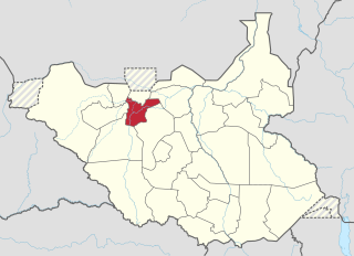
Wau State was a state in South Sudan that existed between 2 October 2015 and 22 February 2020. It was located in the Bahr el Ghazal region, and was part of the former state of Western Bahr el Ghazal. Wau State bordered Aweil State, Gbudwe State, Gogrial State, Lol State, and Tonj State.
Twic State was a state in South Sudan that existed between 2 October 2015 and 22 February 2020. It was located in the Bahr el Ghazal region and it bordered Aweil East to the west, the disputed Abyei region to the north, Gogrial to the south, Northern Liech to the east, and Ruweng to the northeast. The population of Twic State was recorded at 204,905 in 2008, and was estimated at a population of 543,410 in 2014. The capital of the state was Mayen-Abun, with an estimated population of around 2,000 people in city limits.
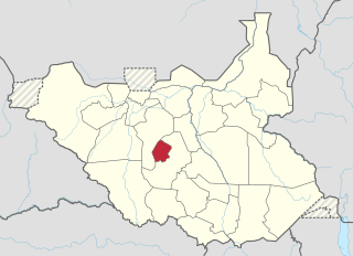
Gogrial State was a state in South Sudan that existed between 2 October 2015 and 22 February 2020. It was located in the Bahr el Ghazal region and it bordered Twic to the north, Aweil East to the northwest, Aweil to the west, Wau to the southwest, Tonj to the southeast, and Northern Liech to the northeast.

Eastern Lakes State was a state in South Sudan that existed between 2 October 2015 and 22 February 2020. It was located in the Bahr el Ghazal region and it bordered Southern Liech to the north, Western States to the west, Amadi to the southwest, Terekeka to the southeast, and Jonglei to the east.
Gok was a state in South Sudan that existed between 2 October 2015 and 22 February 2020. It was located in the Bahr el Ghazal region, and was formerly part of the Lakes State. Gok State bordered Tonj to the west and Western Lakes to the east. The state had a population of 117,755 in 2008 and an estimated population of 174,460 in 2014.

Western Lakes was a state in South Sudan that existed between 2 October 2015 and 22 February 2020. It was located in the Bahr el Ghazal region and was part of the former state of Lakes State. It bordered Amadi State, Eastern Lakes State, Gbudwe State, Gok, Maridi State, Southern Liech State, and Tonj State.

The Ruweng Administrative Area is an administrative area in South Sudan. The area was known as Ruweng State between 2 October 2015 and 22 February 2020 when it was a state of South Sudan.
Deng Deng Akuei (Deng Manyuom) has been the Governor of Aweil East State, South Sudan since 24 December 2015. He is the first governor of the state, which was created by President Salva Kiir on 2 October 2015.
The 2014 retreat from Western Bahr el Ghazal, also called the long march north, was an unorganized withdrawal by hundreds of Nuer Sudan People's Liberation Army (SPLA) deserters who sought to flee from Bahr el Ghazal to Sudan during the South Sudanese Civil War. After longstanding tensions between SPLA soldiers belonging to the Dinka and Nuer ethnic groups escalated on 25 April 2014, leading to a massacre of Nuer soldiers at Mapel in Western Bahr el Ghazal, a large number of Nuer SPLA soldiers deserted to escape ethnic prosecution and loyalist SPLA forces. Though some deserters joined SPLM-IO rebels or surrendered to the government, a large number of them marched northward, joined by other SPLA defectors from Northern Bahr el Ghazal. After covering over 400 kilometres (250 mi), this trek eventually arrived in Sudan on 4 August 2014, where they were disarmed.
This article lists events from the year 2019 in South Sudan
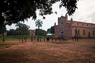
Aroyo is a town in Northern Bahr el Ghazal, South Sudan.
