Fawn River (Michigan)

Last updated
Fawn River

Fawn River Florence Township Michigan.jpg

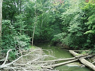
The Fawn River in Florence Township, Michigan
Country United States
Physical characteristics
Main source Steuben County north of Orland, Indiana
939 ft (286 m)
41°44′19″N85°10′01″W / 41.7386111°N 85.1669444°W / 41.7386111; -85.1669444 (Fawn River origin)
River mouth Confluence with the St. Joseph River at Constantine, Michigan
774 ft (236 m)
41°50′45″N85°40′02″W / 41.8458333°N 85.6672222°W / 41.8458333; -85.6672222 (Fawn River mouth) Coordinates: 41°50′45″N85°40′02″W / 41.8458333°N 85.6672222°W / 41.8458333; -85.6672222 (Fawn River mouth)
Length 55 mi (89 km)
Basin features
Progression Fawn River → St. Joseph River → Lake Michigan → Great Lakes → St. Lawrence River → Gulf of St. Lawrence
GNIS ID 452598
Map all coordinates using: OpenStreetMap  ·  Google Maps
Download coordinates as: KML  ·  GPX

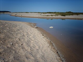
The Fawn River is a 55.4-mile-long (89.2 km) [1] river in southwest Michigan and northeast Indiana in the United States. It flows into the St. Joseph River in the city of Constantine, Michigan. The headwaters rise in a series of lakes and marshes in northern Steuben County, Indiana near Pokagon State Park, where it is known as "Crooked Creek" and "Little Fawn River". It flows west-northwest across the northeast corner of LaGrange County, Indiana and then over the state line across the southeast corner of Branch County, Michigan before entering St. Joseph County, Michigan. Passing to the south of Sturgis, Michigan, the river meanders across the state line a few more times before flowing north into Constantine. Except for Constantine, the river does not flow through any large communities, although it passes near Fremont, Indiana, Orland, Indiana, Sturgis, Howe, Indiana, and White Pigeon, Michigan.

River Natural flowing watercourse

A river is a natural flowing watercourse, usually freshwater, flowing towards an ocean, sea, lake or another river. In some cases a river flows into the ground and becomes dry at the end of its course without reaching another body of water. Small rivers can be referred to using names such as stream, creek, brook, rivulet, and rill. There are no official definitions for the generic term river as applied to geographic features, although in some countries or communities a stream is defined by its size. Many names for small rivers are specific to geographic location; examples are "run" in some parts of the United States, "burn" in Scotland and northeast England, and "beck" in northern England. Sometimes a river is defined as being larger than a creek, but not always: the language is vague.

Michigan State of the United States of America

Michigan is a state in the Great Lakes and Midwestern regions of the United States. The state's name, Michigan, originates from the Ojibwe word mishigamaa, meaning "large water" or "large lake". With a population of about 10 million, Michigan is the tenth most populous of the 50 United States, with the 11th most extensive total area, and is the largest state by total area east of the Mississippi River. Its capital is Lansing, and its largest city is Detroit. Metro Detroit is among the nation's most populous and largest metropolitan economies.

Indiana State of the United States of America

Indiana is a U.S. state located in the Midwestern and Great Lakes regions of North America. Indiana is the 38th largest by area and the 17th most populous of the 50 United States. Its capital and largest city is Indianapolis. Indiana was admitted to the United States as the 19th U.S. state on December 11, 1816. Indiana borders Lake Michigan to the northwest, Michigan to the north, Ohio to the east, Kentucky to the south and southeast, and Illinois to the west.

Contents

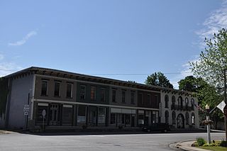
Fawn River Township, Michigan is named after the river.

Fawn River Township, Michigan Township in Michigan, United States

Fawn River Township is a civil township of St. Joseph County in the U.S. state of Michigan. The population was 1,648 at the 2000 census. The township is named for the Fawn River.

Drainage basin

The drainage basin for the Fawn River and tributaries includes all or portions of the following:

Drainage basin Area of land where precipitation collects and drains off into a common outlet

A drainage basin is any area of land where precipitation collects and drains off into a common outlet, such as into a river, bay, or other body of water. The drainage basin includes all the surface water from rain runoff, snowmelt, and nearby streams that run downslope towards the shared outlet, as well as the groundwater underneath the earth's surface. Drainage basins connect into other drainage basins at lower elevations in a hierarchical pattern, with smaller sub-drainage basins, which in turn drain into another common outlet.

Steuben County, Indiana County in the United States

Steuben County is a county located in the northeast corner of the U.S. state of Indiana. The county was named after Baron von Steuben, a Prussian military officer who helped train the Continental Army during the American Revolutionary War.

Fremont Township, Steuben County, Indiana Township in Indiana, United States

Fremont Township is one of twelve townships in Steuben County, Indiana, United States. As of the 2010 census, its population was 2,993 and it contained 1,224 housing units.

Jamestown Township, Steuben County, Indiana Township in Indiana, United States

Jamestown Township is one of twelve townships in Steuben County, Indiana, United States. As of the 2010 census, its population was 3,249 and it contained 2,937 housing units.

Tributaries

(from the mouth)

Becomes the Crooked Creek [27]

See also

Related Research Articles

St. Joseph River (Maumee River tributary) tributary of the Maumee River in Ohio and Indiana

The St. Joseph River is an 86.1-mile-long (138.6 km) tributary of the Maumee River in northwestern Ohio and northeastern Indiana in the United States, with headwater tributaries rising in southern Michigan. It drains a primarily rural farming region in the watershed of Lake Erie.

Bear River (Michigan) small clear slow moving river in the U.S. state of Michigan

Bear River is a small clear slow-moving river in the U.S. state of Michigan. 14.7 miles (23.7 km) long, it is the largest tributary of Little Traverse Bay in the northwest of the lower peninsula. Traverse Bay is on Lake Michigan. The river is formed as the outflow of Walloon Lake on the boundary between Charlevoix County and Emmet County, draining from the southeast end of the lake at 45°15′40″N84°56′01″W near the community of Walloon Lake in Melrose Township. M-75 has its northern terminus in a junction with US 131 nearby.

Platte River (Michigan) river in Michigan

The Platte River is located in the northern part of the Lower Peninsula of Michigan. Its mouth is located in Sleeping Bear Dunes National Lakeshore and much of the rest is in the Pere Marquette State Forest.

Chippewa River (Michigan) river in Michigan

The Chippewa River is a stream in the U.S. state of Michigan that runs 91.8 miles (147.7 km) through the central Lower Peninsula. The Chippewa is a tributary of the Tittabawassee River and is thus part of the Saginaw River drainage basin. The river is named after the Chippewa people.

Carp River is a 40.2-mile-long (64.7 km) river in Chippewa and Mackinac counties in the U.S. state of Michigan. 21.7 miles (34.9 km) of the river were added to the National Wild and Scenic Rivers System in 1992.

Black River (Southwest Michigan) river in southwest Michigan

Black River is a 4.2-mile-long (6.8 km) river in the southwest part of the U.S. state of Michigan that empties into Lake Michigan in South Haven at 42°24′08″N86°17′04″W, where it discharges past the South Pier Lighthouse. The river takes its name from the dark brown color of its water, which is caused by suspended sediments and organic materials picked up along its course. The river supports a variety of wildlife including trout, snapping turtles, leeches, and many other varieties of flora and fauna. The Black River watershed encompasses 287 square miles (740 km2) across two counties and 13 townships.

Dowagiac River river in the United States of America

The Dowagiac River is a southwesterly flowing 30.9-mile-long (49.7 km) stream in the Lower Peninsula of the U.S. state of Michigan. It is tributary to the St. Joseph River which flows, in turn, into eastern Lake Michigan.

Cedar River (Gladwin County, Michigan) river in Clare and Gladwin counties, Michigan, United States

The Cedar River is a 29.0-mile-long (46.7 km) river in the U.S. state of Michigan, flowing through Clare County and Gladwin County.

Cedar River is a 67.1-mile-long (108.0 km) river in the U.S. state of Michigan. It rises in the northern part of Menominee County at 45°53′18″N87°35′15″W and flows mostly south and east to empty into Green Bay of Lake Michigan at 45°24′35″N87°21′05″W in the community of Cedar River.

Rocky River (Michigan) river in United States of America

The Rocky River is a 28.3-mile-long (45.5 km) stream located in the southwest part of the U.S. state of Michigan that flows into the St. Joseph River at 41°56′33″N85°37′59″W in the city of Three Rivers in St. Joseph County. The Rocky River, along with the St. Joseph River and the Portage River, are the three rivers from which the city of Three Rivers takes its name.

Coldwater River is a 29.5-mile-long (47.5 km) stream in the U.S. state of Michigan. Located in Branch County, the river rises in Ovid Township at 41°50′14″N84°59′13″W as the outflow of Coldwater Lake. Flowing north and west, it is joined by the outflow from the Lake of the Woods and continues north for several miles. West of the city of Coldwater, it flows through a series of lakes: South Lake, Messenger Lake, Cemetery Lake, North Lake, Randall Lake, Morrison Lake, Craig Lake, and Hodunk Pond. It then continues to the northwest and empties into the St. Joseph River in the village of Union City at 42°03′58″N85°07′48″W.

Coldwater River (Western Michigan) river in Michigan, United States of America

The Coldwater River is a 19.4-mile-long (31.2 km) stream in the U.S. state of Michigan. Located in western Michigan, the river is a part of the Grand River drainage basin.

Galien River river in the United States of America

The Galien River is a 30.0-mile-long (48.3 km) stream in the southwest region of the U.S. state of Michigan. The river begins at the outlet of Dayton Lake and flows in a predominantly westerly direction until it enters southeastern Lake Michigan at New Buffalo. The South Branch Galien River rises just north of the border with Indiana, at the confluence of Spring Creek and the Galena River, the latter rising in LaPorte County, Indiana.

Prairie River (Michigan) river in the United States of America

The Prairie River is a small river that flows 54 miles (87 km) through Branch and St. Joseph counties in Michigan. The river rises at 41°48′20″N85°00′54″W in northern Kinderhook Township in Branch County, and flows west-northwest into the St. Joseph River at 41°54′45″N85°38′21″W just south of the city of Three Rivers, Michigan.

Ocqueoc River river in the United States of America

The Ocqueoc River is stream in Presque Isle County in the northeastern part of the lower peninsula in the U.S. state of Michigan. It is 34.2 miles (55.0 km) long and encompasses a watershed of approximately 94,394 acres (382.00 km2).

Klingers is an unincorporated community in St. Joseph County in the southwest region of the U.S. state of Michigan.

Nottawa Creek is a 33.9-mile-long (54.6 km) stream in the U.S. state of Michigan that flows into the St. Joseph River at 42°00′15″N85°23′40″W, approximately three miles east of the village of Mendon.

Portage River (Jackson County, Michigan) river in United States of America

The Portage River is a 15.5-mile-long (24.9 km) river in the U.S. state of Michigan, flowing mostly southwesterly through northeast Jackson County.

Pine River (Chippewa River) tributary of the Chippewa River in the Lower Peninsula of the U.S. state of Michigan

The Pine River is a 103-mile-long (166 km) river in the Lower Peninsula of the U.S. state of Michigan. The Pine River is a tributary of the Chippewa River and is thus part of the Saginaw River drainage basin.

References

  1. U.S. Geological Survey. National Hydrography Dataset high-resolution flowline data. The National Map Archived 2012-04-05 at WebCite , accessed May 19, 2011
  2. 1 2 U.S. Geological Survey Geographic Names Information System: Anderson Lake
  3. U.S. Geological Survey Geographic Names Information System: Fawn River Drain
  4. U.S. Geological Survey Geographic Names Information System: Klinger Lake
  5. U.S. Geological Survey Geographic Names Information System: Tamarack Lake
  6. U.S. Geological Survey Geographic Names Information System: Thompson Lake
  7. U.S. Geological Survey Geographic Names Information System: Pickerel Lake
  8. U.S. Geological Survey Geographic Names Information System: Aldrich Lake
  9. U.S. Geological Survey Geographic Names Information System: Wenger Ditch
  10. U.S. Geological Survey Geographic Names Information System: Nye Drain
  11. U.S. Geological Survey Geographic Names Information System: Cedar Lake
  12. U.S. Geological Survey Geographic Names Information System: Meteer Lake
  13. U.S. Geological Survey Geographic Names Information System: Duff Lake
  14. U.S. Geological Survey Geographic Names Information System: Lee Lake
  15. U.S. Geological Survey Geographic Names Information System: Williams Lake
  16. U.S. Geological Survey Geographic Names Information System: Baker Lake
  17. U.S. Geological Survey Geographic Names Information System: Dark Lake
  18. U.S. Geological Survey Geographic Names Information System: Cade Lake
  19. U.S. Geological Survey Geographic Names Information System: Sweet Lake
  20. U.S. Geological Survey Geographic Names Information System: Himebaugh Drain
  21. U.S. Geological Survey Geographic Names Information System: Long Noble Lake
  22. U.S. Geological Survey Geographic Names Information System: Royer Lake
  23. U.S. Geological Survey Geographic Names Information System: Mallow Lake
  24. 1 2 U.S. Geological Survey Geographic Names Information System: Fish Lake
  25. U.S. Geological Survey Geographic Names Information System: Honey Lake
  26. U.S. Geological Survey Geographic Names Information System: Lime Lake
  27. U.S. Geological Survey Geographic Names Information System: Crooked Creek
  28. U.S. Geological Survey Geographic Names Information System: Tamarack Lake
  29. U.S. Geological Survey Geographic Names Information System: Warner Lake
  30. U.S. Geological Survey Geographic Names Information System: Chair Factory Lake
  31. U.S. Geological Survey Geographic Names Information System: Rhodes Lake
  32. U.S. Geological Survey Geographic Names Information System: Lime Lake
  33. U.S. Geological Survey Geographic Names Information System: Lake Gage
  34. U.S. Geological Survey Geographic Names Information System: Crooked Lake
  35. U.S. Geological Survey Geographic Names Information System: Look Lake
  36. U.S. Geological Survey Geographic Names Information System: Center Lake
  37. U.S. Geological Survey Geographic Names Information System: Bell Lake
  38. U.S. Geological Survey Geographic Names Information System: Jimmerson Lake
  39. U.S. Geological Survey Geographic Names Information System: Lake James
  40. U.S. Geological Survey Geographic Names Information System: Snow Lake
  41. U.S. Geological Survey Geographic Names Information System: Follette Creek
  42. U.S. Geological Survey Geographic Names Information System: Big Otter Lake
  43. U.S. Geological Survey Geographic Names Information System: Walters Lake
  44. U.S. Geological Survey Geographic Names Information System: Little Otter Lake
  45. U.S. Geological Survey Geographic Names Information System: Green Lake
  46. U.S. Geological Survey Geographic Names Information System: Marsh Lake
  47. U.S. Geological Survey Geographic Names Information System: Seven Sisters Lakes
  48. U.S. Geological Survey Geographic Names Information System: Lake Minfenokee
  49. U.S. Geological Survey Geographic Names Information System: Lake George
  50. U.S. Geological Survey Geographic Names Information System: Silver Lake
  51. U.S. Geological Survey Geographic Names Information System: Huyck Lake
  52. U.S. Geological Survey Geographic Names Information System: Little Fawn River