Howe, Indiana

Last updated

Howe, Indiana
HoweIN HoweCenterShops.jpg
Shops in the center of Howe
LaGrange County Indiana Incorporated and Unincorporated areas Howe Highlighted 1834978.svg
Location in LaGrange County, Indiana
USA Indiana location map.svg
Red pog.svg
Howe
Location in Indiana
Usa edcp location map.svg
Red pog.svg
Howe
Location in the United States
Coordinates: 41°43′22″N85°25′32″W / 41.72278°N 85.42556°W / 41.72278; -85.42556
Country United States
State Indiana
County LaGrange
Township Lima
Area
[1]
  Total
1.79 sq mi (4.63 km2)
  Land1.79 sq mi (4.63 km2)
  Water0.00 sq mi (0.00 km2)
Elevation
[2]
876 ft (267 m)
Population
 (2020)
  Total
610
  Density341.16/sq mi (131.74/km2)
ZIP code
46746
FIPS code 18-34978
GNIS feature ID2629774 [2]

Howe is an unincorporated community and census-designated place in Lima Township, LaGrange County, Indiana. As of the 2010 census its population was 807. [3]

Contents

History

Howe was settled in 1834. At that time, it was named "Mongoquinong", a name that the Potawatomi people had given to the prairie in northeastern Indiana. Shortly thereafter it was renamed "Lima" and was, at that time, the county seat. It was later renamed "Howe" after John B. Howe, a local attorney. [4]

The Howe Military School, the town's most famous attraction, was founded in 1884.

Lima, Indiana (now Howe) in 1876 Howe (Lima) Indiana 1876.PNG
Lima, Indiana (now Howe) in 1876

Local places on the National Register

Sites in Howe on the National Register of Historic Places are:

Kingsbury Hotel

Geography

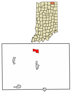
Howe is located in northern LaGrange County at the intersection of State Road 120 and State Road 9. It is the principal community in Lima Township. It is 2 miles (3 km) south of Interstate 80/90 (the Indiana Toll Road), and 5 miles (8 km) north of LaGrange, the county seat.

According to the U.S. Census Bureau, the Howe census-designated place has an area of 1.8 square miles (4.6 km2), all of it recorded as land. [5] The Pigeon River, a tributary of the St. Joseph River, flows westward along the southern edge of the community.

Demographics

Historical population
CensusPop.Note
2010 807
2020 610−24.4%
U.S. Decennial Census [6]

References

  1. "2020 U.S. Gazetteer Files". United States Census Bureau. Retrieved March 16, 2022.
  2. 1 2 U.S. Geological Survey Geographic Names Information System: Howe, Indiana
  3. "Profile of General Population and Housing Characteristics: 2010 Census Summary File 1 (DP-1), Howe CDP, Indiana". American FactFinder. U.S. Census Bureau. Archived from the original on February 13, 2020. Retrieved January 21, 2020.
  4. Baker, Ronald L. (October 1995). From Needmore to Prosperity: Hoosier Place Names in Folklore and History . Indiana University Press. p.  172. ISBN   978-0-253-32866-3. ...renamed for lawyer John B. Howe...
  5. "U.S. Gazetteer Files: 2019: Places: Indiana". U.S. Census Bureau Geography Division. Retrieved January 21, 2020.
  6. "Census of Population and Housing". Census.gov. Retrieved June 4, 2016.