Felonica | |
---|---|
Frazione | |
Coordinates: 44°59′N11°21′E / 44.983°N 11.350°E Coordinates: 44°59′N11°21′E / 44.983°N 11.350°E | |
Country | |
Region | Lombardy |
Province | Province of Mantua (MN) |
Comune | Sermide e Felonica |
Area | |
• Total | 22.5 km2 (8.7 sq mi) |
Population (December 2004) | |
• Total | 1,586 |
• Density | 70/km2 (180/sq mi) |
Time zone | CET (UTC+1) |
• Summer (DST) | CEST (UTC+2) |
Postal code | 46022 |
Dialing code | 0386 |
Website | Official website |
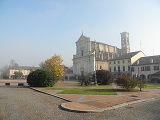
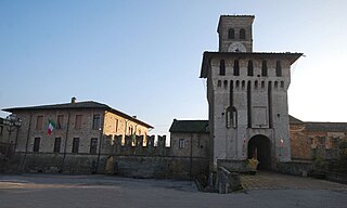
Felonica was a comune (municipality) in the Province of Mantua in the Italian region Lombardy, located about 180 kilometres (110 mi) southeast of Milan and about 50 kilometres (31 mi) southeast of Mantua. It's a frazione of Sermide e Felonica since 2017. As of 31 December 2004 [update] , it had a population of 1,586 and an area of 22.5 square kilometres (8.7 sq mi). [1]
The comune is a basic administrative division in Italy, roughly equivalent to a township or municipality.
The Province of Mantua is a province in the Lombardy region of northern Italy. Its capital is the city of Mantua. It is bordered to the north-east by the Province of Verona, to the east by that of Rovigo, to the south by those of Ferrara, Modena, Reggio Emilia and Parma, to the west by the Province of Cremona and to the north-west by that of Brescia.
Lombardy is one of the twenty administrative regions of Italy, in the northwest of the country, with an area of 23,844 square kilometres (9,206 sq mi). About 10 million people, forming one-sixth of Italy's population, live in Lombardy and about a fifth of Italy's GDP is produced in the region, making it the most populous and richest region in the country and one of the richest regions in Europe. Milan, Lombardy's capital, is the second-largest city and the largest metropolitan area in Italy.
Global data: Province: Mantova. Distance from the chief town (Mantova): 60 kilometres (37 mi). Inhabitants: 1.649. Denomination: Felonichesi.
Geographic data: Surface: 22.5 square kilometres (8.7 sq mi). Elevation above sea level: 11 metres (36 ft). Minimum elevation: 9 metres (30 ft). Maximum elevation: 11 metres (36 ft). Altimetric difference: 2 metres (6.6 ft).
Population and statistical data: Population density: 73.29 inhabitants per square kilometer. Population in 1991: 1,810 inhabitants - Population in 2001: 1,649 inhabitants. Percentage variation: -8.90%. Families: 684. Medium value of the components of a generic family: 2.41 people.
The municipality of Felonica contains the frazione (subdivision) Quatrelle, the easternmost settlement in Lombardy.
"Frazione" is the Italian name given in administrative law to a type of territorial subdivision of a comune; for other administrative divisions, see municipio, circoscrizione, quartiere. It is cognate to the English word fraction, but in practice is roughly equivalent to "parishes" or "wards" in other countries.
This village invented a local bread called "Tirot" which is made with onion.
Bagnolo San Vito is a comune (municipality) in the Province of Mantua in the Italian region Lombardy, located about 140 kilometres (87 mi) southeast of Milan and about 11 kilometres (7 mi) southeast of Mantua.
Borgofranco sul Po is a comune (municipality) in the Province of Mantua in the Italian region Lombardy, located about 170 kilometres (110 mi) southeast of Milan and about 35 kilometres (22 mi) southeast of Mantua.
Carbonara di Po is a comune (municipality) in the Province of Mantua in the Italian region Lombardy, located about 170 kilometres (110 mi) east of Milan and about 35 kilometres (22 mi) southeast of Mantua.
Casalromano is a comune (municipality) in the Province of Mantua in the Italian region Lombardy, located about 100 kilometres (62 mi) southeast of Milan and about 35 kilometres (22 mi) west of Mantua. As of 31 December 2004, it had a population of 1,568 and an area of 11.9 square kilometres (4.6 sq mi).
Commessaggio is a comune (municipality) in the Province of Mantua in the Italian region Lombardy, located about 120 kilometres (75 mi) southeast of Milan and about 25 kilometres (16 mi) southwest of Mantua.
Dosolo is a comune (municipality) in the Province of Mantua in the Italian region Lombardy, located about 130 kilometres (81 mi) southeast of Milan and about 25 kilometres (16 mi) southwest of Mantua. As of 31 December 2004, it had a population of 3,265 and an area of 26.0 square kilometres (10.0 sq mi).
Magnacavallo is a comune (municipality) in the Province of Mantua in the Italian region Lombardy, located about 170 kilometres (110 mi) southeast of Milan and about 45 kilometres (28 mi) southeast of Mantua.
Moglia is a comune (municipality) in the Province of Mantua in the Italian region Lombardy, located about 150 kilometres (93 mi) southeast of Milan and about 30 kilometres (19 mi) southeast of Mantua.
Motteggiana is a comune (municipality) in the Province of Mantua in the Italian region Lombardy, located about 130 kilometres (81 mi) southeast of Milan and about 15 kilometres (9 mi) south of Mantua. As of 31 December 2004, it had a population of 2,629 and an area of 24.6 square kilometres (9.5 sq mi).
Quingentole is a comune (municipality) in the Province of Mantua in the Italian region Lombardy, located about 160 kilometres (99 mi) southeast of Milan and about 30 kilometres (19 mi) southeast of Mantua.
Quistello is a comune (municipality) in the Province of Mantua in the Italian region Lombardy, located about 150 kilometres (93 mi) southeast of Milan and about 20 kilometres (12 mi) southeast of Mantua.
Redondesco is a comune (municipality) in the Province of Mantua in the Italian region Lombardy, located about 110 kilometres (68 mi) southeast of Milan and about 20 kilometres (12 mi) west of Mantua. As of 31 December 2004, it had a population of 1,378 and an area of 19.1 square kilometres (7.4 sq mi).
Revere is a frazione of Borgo Mantovano in the Province of Mantua in Lombardy, northern Italy, located about 160 kilometres (99 mi) southeast of Milan and about 30 kilometres (19 mi) southeast of Mantua. It was a separate comune until 2018; it now houses the municipal seat of Borgo Mantovano.
San Benedetto Po is a comune (municipality) in the Province of Mantua in the Italian region Lombardy, located about 150 kilometres (93 mi) southeast of Milan and about 15 kilometres (9 mi) southeast of Mantua. It is best known as the location of the Polirone Abbey.
San Giacomo delle Segnate is a comune (municipality) in the Province of Mantua in the Italian region Lombardy, located about 160 kilometres (99 mi) southeast of Milan and about 30 kilometres (19 mi) southeast of Mantua.
San Giovanni del Dosso is a comune (municipality) in the Province of Mantua in the Italian region Lombardy, located about 160 kilometres (99 mi) southeast of Milan and about 30 kilometres (19 mi) southeast of Mantua.
Schivenoglia is a comune (municipality) in the Province of Mantua in the Italian region Lombardy, located about 160 kilometres (99 mi) southeast of Milan and about 30 kilometres (19 mi) southeast of Mantua.
Sermide was a comune (municipality) in the Province of Mantua in the Italian region Lombardy, located about 180 kilometres (110 mi) southeast of Milan and about 45 kilometres (28 mi) southeast of Mantua. It is now a frazione of Sermide e Felonica since 2017.
Sustinente is a comune (municipality) in the Province of Mantua in the Italian region Lombardy, located about 140 kilometres (87 mi) southeast of Milan and about 11 kilometres (7 mi) southeast of Mantua.
Virgilio is a frazione of the comune (municipality) of Borgo Virgilio in the Province of Mantua in the Italian region Lombardy, located about 130 kilometres (81 mi) southeast of Milan and about 6 kilometres (4 mi) south of Mantua. It was a separate comune until 2014.
This article on a location in the Province of Mantua is a stub. You can help Wikipedia by expanding it. |