
Taboga Island, also known as the "Island of Flowers", is a volcanic island in the Gulf of Panama. It is a tourist destination, about 20 km from Panama City, Panama.

Gustavo Rojas Pinilla International Airport is the main airport in the archipelago of San Andrés, Providencia and Santa Catalina, one of the departments of Colombia. It is able to receive large aircraft and to accommodate seasonal and charter flights from different parts of the Americas and Europe.
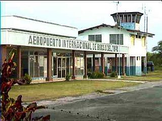
Bocas del Toro "Isla Colón" International Airport is a public airport located 1.5 kilometres (1 mi) northwest of the center of Bocas del Toro, a town on Isla Colón in the Bocas del Toro Province of Panama.

Albrook "Marcos A. Gelabert" International Airport is a public airport located 1.5 kilometres (1 mi) west of the center of Panama City, in the Panamá Province of Panama. It is on the site of the former Albrook Air Force Station. Previously, the airport was located in the area of Paitilla Punta Paitilla, operating approximately 70 years until January 1999, when the airport moved operations to Albrook. The name was changed to honor the Panamanian aviator Marcos A. Gelabert, whose contributions to Panamanian aviation included founding Panama's first airline and first school for training pilots.

Chame Airport is an airport serving Chame District, a district in the Panamá Oeste Province of Panama.
Achutupo Airport is an airport serving the island town of Achutupo, in the San Blas archipelago of Panama. The runway is located on the mainland, 0.7 kilometres (0.4 mi) southwest of the island and is reached by boat.
Raul Arias Espinoza Airport is a domestic airport serving Contadora Island, in Panama's Pearl Islands archipelago.
Playón Chico Airport is an airport serving Ukupseni, an island in the San Blas Archipelago in the Guna Yala comarca of Panama.
Mulatupo Airport is an airport serving the Caribbean island town of Mulatupo, in the Guna Yala comarca of Panama.
Ustupu-Ogobsucum Airport is an airport serving the island town of Ustupo in the Guna Yala comarca of Panama. It handles domestic flights and general aviation.
Corazón de Jesús Airport is an airstrip serving Corazón de Jesús and Narganá, island towns in the Guna Yala comarca of Panama.
El Porvenir Airport is an airport serving El Porvenir, in Panama. The airport is on an island 2 kilometres (1.2 mi) east of the mainland, in the archipelago bordering the Gulf of San Blas. All approaches and departures will be over the water.
Ailigandí Airport is an airstrip serving Ailigandí, an island town in the Guna Yala comarca of Panama. The airstrip is onshore, approximately 400 metres (1,312 ft) southeast of Ailigandí island and is reached by boat. There are no roads near the airstrip.
Ustupo Airport is a secondary airport serving the island town of Ustupo, Guna Yala comarca, Panama. It is 800 metres (0.5 mi) southwest on the mainland and reachable from the town by a boat.
San Miguel Airport is an airport serving San Miguel, a town in the Pearl Islands of Panama. It is just east of the town, on the northern side of Isla del Rey, the largest of the islands.
Tubualá Airport is an airport serving the island town of Tubualá, in the Guna Yala Province of Panama.
Cartí Airport is an airport serving the Cartí islands in the San Blas Archipelago of Panama. The airport is on the mainland, approximately 0.7 kilometres (0.4 mi) southwest of Cartí Sugtupu island.
San José Airport is an airport serving the island of San José, in the Pearl Islands archipelago of Panama.
Panamá Pacífico International Airport is a commercial airport in Panama. It is located on the site of the former Howard Air Force Base, a United States Air Force base that was within the Panama Canal Zone. Panama City can be reached by crossing the nearby Bridge of the Americas.


