Fire Control Tower No. 23

Last updated
Fire Control Tower No. 23
Fire Control Tower 23.JPG
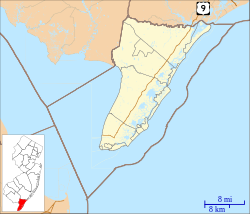
Location map of Cape May County, New Jersey.svg
Red pog.svg
USA New Jersey location map.svg
Red pog.svg
Usa edcp location map.svg
Red pog.svg
LocationSunset Boulevard, Lower Township, New Jersey
Coordinates 38°56′36″N74°58′3″W / 38.94333°N 74.96750°W / 38.94333; -74.96750
Built1942
Architectural styleFire Control Tower
NRHP reference No. 03000655 [1]
NJRHP No.4169 [2]
Significant dates
Added to NRHPNovember 17, 2003
Designated NJRHPMay 29, 2003

Fire Control Tower No. 23 is a NRHP-listed tower located in Lower Township of Cape May County, New Jersey, United States. The tower was built in 1942 as part of Fort Miles, the system of harbor defenses of the Delaware Bay. It was one of 15 towers from North Wildwood, New Jersey to Bethany Beach, Delaware used to aim coastal batteries at German ships and submarines. It is located near Sunset Beach in Cape May Point State Park.

Contents

The tower was added to the New Jersey Register of Historic Places on May 29, 2003, and to the National Register of Historic Places on November 17, 2003, for its significance in military history. [1] [3] About this time the tower was renovated under the direction of architect Robert Russell. Spiral staircases, lighting and safety features were installed, allowing the public to climb to the top of the tower and a wooden walkway was built to Sunset Avenue. [4]

Historical information sign about the fire control tower Fire Control Tower No. 23 information sign, Sunset Beach, NJ.jpg
Historical information sign about the fire control tower

See also

Related Research Articles

<span class="mw-page-title-main">Lewes, Delaware</span> City in Delaware, United States

Lewes is an incorporated city on the Delaware Bay in eastern Sussex County, Delaware, United States. According to the 2020 census, its population was 3,303. Along with neighboring Rehoboth Beach, Lewes is one of the principal cities of Delaware's rapidly growing Cape Region. The city lies within the Salisbury, Maryland–Delaware Metropolitan Statistical Area. Lewes proudly claims to be "The First Town in The First State."

<span class="mw-page-title-main">Cape Henlopen State Park</span> State park in Delaware, United States

Cape Henlopen State Park is a Delaware state park on 5,193 acres (2,102 ha) on Cape Henlopen in Sussex County, Delaware, in the United States. William Penn made the beaches of Cape Henlopen one of the first public lands established in what has become the United States in 1682 with the declaration that Cape Henlopen would be for "the usage of the citizens of Lewes and Sussex County." Cape Henlopen State Park has a 24-hour and year-round fishing pier as well as campgrounds. The remainder of the park is only open from sunrise to sunset, and includes a bathhouse on the Atlantic Ocean, an area for surf-fishing, a disc golf course, and bicycle and walking paths. The beach at Herring Point is a popular surfing spot. The park is a stop on Delaware's Coastal Heritage Greenway.

<span class="mw-page-title-main">Cape Henlopen</span> Cape in Delaware, United States

Cape Henlopen is the southern cape of the Delaware Bay along the Atlantic coast of the United States. It lies in the state of Delaware, near the town of Lewes, where the Delaware Bay meets the Atlantic Ocean. Off the coast on the bay side are two lighthouses, called the Harbor of Refuge Light and the Delaware Breakwater East End Light.

<span class="mw-page-title-main">Hereford Inlet Lighthouse</span> Lighthouse

The Hereford Inlet Lighthouse is a historic lighthouse located in North Wildwood, New Jersey, situated on the southern shore of Hereford Inlet at the north end of Five Mile Beach. Its construction was completed and it became operational in 1874.

<span class="mw-page-title-main">Cape May Lighthouse</span> Lighthouse in New Jersey, United States

The Cape May Lighthouse is a lighthouse located in the U.S. state of New Jersey at the tip of Cape May, in Lower Township's Cape May Point State Park. It was built in 1859 under the supervision of U.S. Army engineer William F. Raynolds, was automated in 1946, and continues operation to this day.

<span class="mw-page-title-main">Cape May Point State Park</span> State park in Cape May County, New Jersey

Cape May Point State Park is a 244 acres (0.99 km2) state park located in Lower Township, New Jersey, with a Cape May Point postal address. The park offers walking, hiking and nature trails as well as beaches, an exhibit gallery, a ranger office and is the site of the Cape May Light. The park is operated and maintained by the New Jersey Division of Parks and Forestry.

<span class="mw-page-title-main">Washington Crossing Historic Park</span> United States historic place

Washington Crossing Historic Park is a 500-acre (2 km2) state park operated by the Pennsylvania Department of Conservation and Natural Resources in partnership with the Friends of Washington Crossing Park. The park is divided into two sections. One section of the park, the "lower park," is headquartered in the village of Washington Crossing located in Upper Makefield Township in Bucks County, Pennsylvania. It marks the location of George Washington's crossing of the Delaware River during the American Revolutionary War.

<span class="mw-page-title-main">Fort Miles</span>

Fort Miles was a United States Army World War II installation located on Cape Henlopen near Lewes, Delaware. Although funds to build the fort were approved in 1934, it was 1938 before construction began on the fort. On 3 June 1941 it was named for Lieutenant General Nelson A. Miles.

<span class="mw-page-title-main">Fort Mott (New Jersey)</span>

Fort Mott, located in Pennsville, Salem County, New Jersey, United States, was part of the Harbor Defenses of the Delaware, a three-fort defense system designed for the Delaware River during the Reconstruction era and Endicott program modernization periods following the American Civil War and in the 1890s. The other two forts in the system were Fort Delaware on Pea Patch Island and Fort DuPont in Delaware City, Delaware. It was active for the Spanish American War and World War I. It was closed in 1944, and sold to the state of New Jersey to become Fort Mott State Park.

<span class="mw-page-title-main">Fort Delaware State Park</span> State park in Delaware, United States

Fort Delaware State Park is a 288-acre (117 ha), 1 mi (1.6 km) long Delaware state park on Pea Patch Island in the mid channel of the Delaware River near its entrance into Delaware Bay. It is a low, marshy island in New Castle County, Delaware, facing Delaware City on the Delaware shore and Finns Point on the New Jersey shore. Fort Delaware was built on Pea Patch Island by the United States Army in 1815, near the conclusion of the War of 1812, to protect the harbors of Wilmington, Delaware and Philadelphia, Pennsylvania. The fort was burned and rebuilt in the years prior to the American Civil War, and soon after the start of the war the fort was converted to a Prisoner of War camp. Fort Delaware continued to protect the mouth of the Delaware River through World War I and II. Pea Patch Island and Fort Delaware was declared surplus land by the United States Department of Defense in 1945.

<span class="mw-page-title-main">East Point Light</span> Lighthouse

The East Point Light, known as the Maurice River Light before 1913, is a lighthouse located in Heislerville, New Jersey on the Delaware Bay at the mouth of the Maurice River in Maurice River Township, Cumberland County, New Jersey, United States. The lighthouse was built in 1849 and is the second oldest in New Jersey, with only the Sandy Hook Light, which was built in 1764, being older. The light was inactive from 1941 and was nearly destroyed by fire in 1971. The light was reinstated by the United States Coast Guard in 1980. Exterior restoration was completed in 1999.

<span class="mw-page-title-main">Fort DuPont</span>

Fort DuPont, named in honor of Rear Admiral Samuel Francis Du Pont, is located between the original Delaware City and the modern Chesapeake and Delaware Canal on the original Reeden Point tract, which was granted to Henry Ward in 1675. Along with two other forts of the Harbor Defenses of the Delaware, it defended the Delaware River and the water approach to Philadelphia from 1900 through 1942. In 1992 a portion was redesignated as Fort DuPont State Park, which became Delaware's 13th state park. In 2016, the acreage which is not in the state park system was annexed into Delaware City.

<span class="mw-page-title-main">Cape May Historic District</span> Historic district in New Jersey, United States

The Cape May Historic District is an area of 380 acres (1.5 km2) with over 600 buildings in the resort town of Cape May, Cape May County, New Jersey. The city claims to be America's first seaside resort and has numerous buildings in the Late Victorian style, including the Eclectic, Stick, and Shingle styles, as well as the later Bungalow style, many with gingerbread trim. According to National Park Service architectural historian Carolyn Pitts, "Cape May has one of the largest collections of late 19th century frame buildings left in the United States... that give it a homogeneous architectural character, a kind of textbook of vernacular American building."

<span class="mw-page-title-main">Battery 223</span> United States historic place

Battery 223 is in Lower Township, Cape May County, New Jersey, United States. The harbor defense battery was completed in 1943. It was added to the National Register of Historic Places on June 25, 2008.

<span class="mw-page-title-main">Owen Coachman House</span> Historic house in New Jersey, United States

Owen Coachman House is located in Lower Township, Cape May County, New Jersey. The original one-room house was built between 1695 and 1700 in Townbank along Delaware Bay. It was moved to its present location on Shunpike Road on Cape Island in 1846. It was added to the National Register of Historic Places in September 2005.

<span class="mw-page-title-main">Ocean City City Hall</span> United States historic place

Ocean City City Hall is located in Ocean City, Cape May County, New Jersey, United States. The building was built in 1914 and added to the National Register of Historic Places on June 13, 1997. To celebrate its 100th anniversary, it was made the subject of the 2014 Ocean City Seasonal Beach Tag.

<span class="mw-page-title-main">Ocean City Residential Historic District</span> Historic district in New Jersey, United States

Ocean City Residential Historic District consists of 169 properties, dating back to the 1880s, located in Ocean City, New Jersey. The district was added to the National Register of Historic Places on March 20, 2003.

United States lightship <i>Barnegat</i> (LV-79)

The United States lightship Barnegat (LV-79/WAL-506), is located in Camden, Camden County, New Jersey, United States. The lightship was built in 1904 and was added to the National Register of Historic Places on 29 November 1979.

<span class="mw-page-title-main">Battery Steele</span>

Battery Steele is a United States military fortification on Peaks Island, Portland, Maine, in Casco Bay. Completed in 1942 as part of World War II, it is located on 14 acres (5.7 ha) on the oceanside area of the island, formerly part of the Peaks Island Military Reservation. It is named for Harry L. Steele, who was a Coast Artillery officer during World War I. It was armed with two 16-inch MkIIMI guns and, with a 12-inch gun battery at Fort Levett on Cushing Island, replaced all previous heavy guns in the Harbor Defenses of Portland. It was built to protect Casco Bay, particularly Portland harbor, from Kennebunk to Popham Beach in Phippsburg. According to Kim MacIsaac and historian Joel Eastman in An Island at War, “Battery Steele is not only the largest gun battery built on Peaks Island, but also an example of the largest battery ever built anywhere in the United States.” In 1995, after decades of non-use, the Peaks Island Land Preserve, a community land preservation group, formed to purchase the area and forever preserve it as a public space. On October 20, 2005, the property was listed on the National Register of Historic Places. Other coast defense structures on the island include fire control towers and the counterweight for a disappearing searchlight tower.

<span class="mw-page-title-main">Headquarters, New Jersey</span> Populated place in Hunterdon County, New Jersey, US

Headquarters is an unincorporated community located within the Amwell Valley of Delaware Township in Hunterdon County, New Jersey. The settlement is centered around the intersection of Zentek Road and County Route 604. It is about 3 miles (4.8 km) from Ringoes to the east and 1 mile (1.6 km) from Sergeantsville to the west. The Headquarters Historic District was listed on the state and national registers of historic places in 2011 and had its boundary increased in 2016.

References

  1. 1 2 "National Register Information System  (#03000655)". National Register of Historic Places . National Park Service. March 13, 2009.
  2. "New Jersey and National Registers of Historic Places – Cape May County" (PDF). New Jersey Department of Environmental Protection – Historic Preservation Office. March 25, 2024. p. 4.
  3. Newman, Margaret (July 2002). "National Register of Historic Places Inventory/Nomination: Fire Control Tower No. 23". National Park Service. With accompanying 12 photos
  4. "World War II Lookout Tower". Mid-Atlantic Center for the Arts & Humanities. Archived from the original on 2011-07-28. Retrieved September 21, 2011.