Erma, New Jersey | |
---|---|
Coordinates: 38°59′49″N74°53′28″W / 38.996931°N 74.891122°W | |
Country | United States |
State | New Jersey |
County | Cape May |
Township | Lower |
Area | |
• Total | 3.01 sq mi (7.80 km2) |
• Land | 2.92 sq mi (7.55 km2) |
• Water | 0.10 sq mi (0.25 km2) 2.97% |
Elevation | 10 ft (3 m) |
Population | |
• Total | 2,031 |
• Density | 696.26/sq mi (268.84/km2) |
Time zone | UTC−05:00 (Eastern (EST)) |
• Summer (DST) | UTC−04:00 (Eastern (EDT)) |
ZIP Code | |
Area code | 609 |
FIPS code | 34-21660 [5] [6] [7] |
GNIS feature ID | 02389049 [5] [8] |
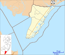
Erma is an unincorporated community and census-designated place (CDP) [9] located within Lower Township in Cape May County, in the U.S. state of New Jersey. [10] As of the 2020 United States census, the CDP's population was 2,031, [3] a decline of 103 from the 2010 census count of 2,134. [11]
According to the United States Census Bureau, the CDP had a total area of 3.360 square miles (8.702 km2), including 3.260 square miles (8.443 km2) of land and 0.100 square miles (0.258 km2) of water (2.97%). [5] [12]
Census | Pop. | Note | %± |
---|---|---|---|
1990 | 2,045 | — | |
2000 | 2,088 | 2.1% | |
2010 | 2,134 | 2.2% | |
2020 | 2,031 | −4.8% | |
Population sources: 2000 [13] 2010 [11] 2020 [3] |
The 2010 United States census counted 2,134 people, 821 households, and 596 families in the CDP. The population density was 654.6 per square mile (252.7/km2). There were 920 housing units at an average density of 282.2 per square mile (109.0/km2). The racial makeup was 95.74% (2,043) White, 1.12% (24) Black or African American, 0.23% (5) Native American, 0.94% (20) Asian, 0.14% (3) Pacific Islander, 0.70% (15) from other races, and 1.12% (24) from two or more races. Hispanic or Latino of any race were 2.62% (56) of the population. [11]
Of the 821 households, 26.6% had children under the age of 18; 55.9% were married couples living together; 10.8% had a female householder with no husband present and 27.4% were non-families. Of all households, 22.9% were made up of individuals and 9.9% had someone living alone who was 65 years of age or older. The average household size was 2.59 and the average family size was 3.04. [11]
21.2% of the population were under the age of 18, 8.4% from 18 to 24, 21.4% from 25 to 44, 34.3% from 45 to 64, and 14.8% who were 65 years of age or older. The median age was 44.4 years. For every 100 females, the population had 96.7 males. For every 100 females ages 18 and older there were 94.3 males. [11]
As of the 2000 United States census [6] of 2000, there were 2,088 people, 751 households, and 561 families living in the CDP. The population density was 240.7/km2 (623.3/mi2). There were 846 housing units at an average density of 97.5/km2 (252.6/mi2). The racial makeup of the CDP was 97.22% White, 0.48% African American, 0.05% Native American, 1.05% Asian, 0.48% from other races, and 0.72% from two or more races. Hispanic or Latino of any race were 1.68% of the population. [13]
There were 751 households, out of which 38.9% had children under the age of 18 living with them, 60.7% were married couples living together, 10.3% had a female householder with no husband present, and 25.2% were non-families. 20.8% of all households were made up of individuals, and 8.7% had someone living alone who was 65 years of age or older. The average household size was 2.77 and the average family size was 3.24. [13]
In the CDP the population was spread out, with 28.4% under the age of 18, 7.3% from 18 to 24, 27.9% from 25 to 44, 24.1% from 45 to 64, and 12.3% who were 65 years of age or older. The median age was 38 years. For every 100 females, there were 97.5 males. For every 100 females age 18 and over, there were 89.6 males. [13]
The median income for a household in the CDP was $64,261, and the median income for a family was $69,063. Males had a median income of $45,694 versus $21,923 for females. The per capita income for the CDP was $20,765. About 1.8% of families and 3.9% of the population were below the poverty line, including 4.9% of those under age 18 and 6.5% of those age 65 or over. [13]
The main transportation route for Erma is U.S. Route 9.
The Cape May Airport is located in Lower Township, [14] and has an Erma postal address though it is not in the CDP. [15] [16]
The Lower Township Police Department station has an Erma address but is outside of the CDP. [17]
As with other parts of Lower Township, it is served by Lower Township School District for primary grades and Lower Cape May Regional School District (LCMR) for secondary grades; [18] the latter operates Teitelman Middle School and Lower Cape May Regional High School.
The LCMR district describes its facilities as being in Erma; [19] the schools and district headquarters are not in the census-designated place. [15] The Cape May County Herald , [20] [21] and the Press of Atlantic City describe the school complex as being in Erma. [22]
The elementary schools are in as follows: David C. Douglass Memorial Elementary School (pre-Kindergarten and Kindergarten) is in Villas CDP. The other three elementary schools are in Cold Spring: Carl T. Mitnick (grades 1-2), Maud Abrams (grades 3-4), and Sandman Consolidated (grades 5-6).
Students are also eligible to attend Cape May County Technical High School in the Cape May Court House area, which serves students from the entire county in its comprehensive and vocational programs, which are offered without charge to students who are county residents. [23] [24] Special needs students may be referred to Cape May County Special Services School District in the Cape May Court House area.
People who were born in, residents of, or otherwise closely associated with Erma include:
Cape May Court House is an unincorporated community and census-designated place (CDP) located within Middle Township in Cape May County, in the U.S. state of New Jersey. It is part of the Ocean City metropolitan statistical area. As of the 2020 United States census, the CDP's population was 5,573, reflecting a 4.4% increase from the 5,338 enumerated at the 2010 U.S. census, in turn an increase of 13.5% from the 4,704 counted in the 2000 census. It is the county seat of Cape May County and serves as the principal administrative hub for the township. It constitutes part of the greater Philadelphia metropolitan area, or the Delaware Valley.
Dennis Township is a township in Cape May County, in the U.S. state of New Jersey. The township, and all of Cape May County, is part of the South Jersey region of the state and of the Ocean City metropolitan statistical area, and is part of the Philadelphia-Wilmington-Camden, PA-NJ-DE-MD combined statistical area, also known as the Delaware Valley or Philadelphia metropolitan area. As of the 2020 United States census, the township's population was 6,285, a decrease of 182 (−2.8%) from the 2010 census count of 6,467, which in turn reflected a decline of 25 (−0.4%) from the 6,492 counted in the 2000 census.
Diamond Beach is an unincorporated community and census-designated place (CDP) located within Lower Township in Cape May County, in the U.S. state of New Jersey. The CDP, and all of Cape May County, is part of the Ocean City metropolitan statistical area, and is part of the Philadelphia-Wilmington-Camden, PA-NJ-DE-MD combined statistical area, also known as the Delaware Valley or Philadelphia metropolitan area. As of the United States 2020 Census, the CDP's population was 203, an increase of 67 from the 2010 census count of 136.
Lower Township is a township in Cape May County, in the U.S. state of New Jersey. The township, and all of Cape May County, is part of the Ocean City metropolitan statistical area, and is part of the Philadelphia-Wilmington-Camden, PA-NJ-DE-MD combined statistical area, also known as the Delaware Valley or Philadelphia metropolitan area. As of the 2020 United States census, the township's population was 22,057, a decrease of 809 (−3.5%) from the 2010 census count of 22,866, which in turn reflected a decrease of 79 (−0.3%) from the 22,945 counted in the 2000 census.
Middle Township is a township in Cape May County, in the U.S. state of New Jersey. The township, and all of Cape May County, is part of the Ocean City metropolitan statistical area, and is part of the Philadelphia-Wilmington-Camden, PA-NJ-DE-MD combined statistical area, also known as the Delaware Valley or Philadelphia metropolitan area. As of the 2020 United States census, the township's population was 20,380, an increase of 1,469 (+7.8%) from the 2010 census count of 18,911, which in turn reflected an increase of 2,506 (+15.3%) from the 16,405 counted in the 2000 census. The township's Cape May Court House section is the county seat of Cape May County.
North Cape May is an unincorporated community and census-designated place (CDP) located within Lower Township in Cape May County, in the U.S. state of New Jersey. It is part of the Ocean City Metropolitan Statistical Area. At the 2010 United States Census, the CDP's population was 3,226. The Cape May–Lewes Ferry departs from the area. North Cape May is mostly a residential community, with no hotels but many vacation homes. Many people retire to the community.
Rio Grande is an unincorporated community and census-designated place (CDP) located within Middle Township and Lower Township in Cape May County, in the U.S. state of New Jersey.
Strathmere is an unincorporated community and census-designated place (CDP) located within Upper Township in Cape May County, in the U.S. state of New Jersey. As of the 2020 United States census, the CDP's population was 137, a decrease of 21 (−13.3%) from the 158 counted at the 2010 U.S. census, which reflected a decrease of 17 (−9.7%) from the 175 enumerated at the 2000 census.
Villas, also known as the Villas, is an unincorporated community and census-designated place (CDP) located within Lower Township, in Cape May County, in the U.S. state of New Jersey. The locality is also home to the community of Miami Beach. At the 2010 census, the CDP's population was 9,483.
Whitesboro-Burleigh was a census-designated place and unincorporated community located within Middle Township, in Cape May County, in the U.S. state of New Jersey. It is part of the Ocean City Metropolitan Statistical Area. As of the 2000 United States Census, the CDP's population was 1,836. In the 2010 United States Census, the Whitesboro-Burleigh CDP was split into two new CDPs, Whitesboro and Burleigh.
Lincroft is an unincorporated community and census-designated place (CDP) within Middletown Township, in Monmouth County, in the U.S. state of New Jersey. As of the 2020 United States census, the CDP had a population of 7,060, reflecting a 15.1% increase from the 6,135 residents enumerated at the 2010 U.S. Census, in turn a decline of 120 residents (-1.9%) from the 6,255 counted in the 2000 U.S. Census.
Morganville is an unincorporated community and census-designated place (CDP) within Marlboro Township, in Monmouth County, New Jersey. As of the 2010 United States Census, the CDP's population was 5,040.
Forked River is an unincorporated community and census-designated place (CDP) located within Lacey Township, in Ocean County, in the U.S. state of New Jersey. As of the 2020 United States census, the CDP's population was 5,274, an increase of 30 (+0.6%) from the 5,244 enumerated at the 2010 census, which in turn reflected an increase of 330 (+6.7%) from the 4.914 counted in the 2000 census.
Pomona is an unincorporated community and census-designated place (CDP) located within Galloway Township, in Atlantic County, in the U.S. state of New Jersey. As of the 2010 United States Census, the CDP's population was 7,124. The area is served as United States Postal Service ZIP Code 08240.
Whitesboro is an unincorporated community and census-designated place (CDP) located within Middle Township in Cape May County, in the U.S. state of New Jersey. Until the 2000 census the area had been part of the Whitesboro-Burleigh CDP, which was split in 2010 into separate CDPs for Burleigh and Whitesboro. As of the 2010 United States Census, the CDP's population was 2,205. Whitesboro was founded as a planned residential community for African Americans and has the majority of the township's black population.
The Lower Cape May Regional High School (LCMRHS) is a four-year comprehensive public high school located in Lower Township, in Cape May County, in the U.S. state of New Jersey, operating as part of the Lower Cape May Regional School District. LCMRHS serves students in ninth through twelfth grades from four communities in Cape May County as part of the Lower Cape May Regional School District, which includes Lower Township, Cape May, West Cape May, and Cape May Point; students from Cape May Point attend the district as part of a sending/receiving relationship.
The Lower Cape May Regional School District is regional public school district headquartered in Lower Township, in the U.S. state of New Jersey, that serves students in seventh through twelfth grades through from four communities in Cape May County, including Lower Township, Cape May City and West Cape May, with students from Cape May Point attending as part of a sending/receiving relationship.
Roebling is an unincorporated community and census-designated place (CDP) located within Florence Township, in Burlington County, in the U.S. state of New Jersey, that was established as part of the 2010 United States census. As of the 2000 United States census, the CDP was combined as Florence-Roebling, which had a total population of 8,200. As of the 2010 Census, the Florence-Roebling CDP was split into its components, Florence and Roebling. As of the 2010 Census, the population of the Florence CDP was 4,426.
Burleigh is an unincorporated community and census-designated place (CDP) located within Middle Township in Cape May County, in the U.S. state of New Jersey; Until the 2000 census the area had been part of the Whitesboro-Burleigh CDP, which was split in 2010 into separate CDPs for Burleigh and Whitesboro. As of the 2010 United States Census, the CDP's population was 725.
Belleplain is an unincorporated community and census-designated place (CDP) located within Dennis Township in Cape May County, in the U.S. state of New Jersey. As of the 2010 United States census, the CDP's population was 597.
Our Physical Address: 1389 Langley Road, Erma, NJ 08204
[...]in the Administration Building, located at 687 Route 9, Erma, Township of Lower, County of Cape May, State of New Jersey.- All LCMR School District facilities have the same postal address.
Lower Cape May Regional High School, in Erma.(photo caption) - As it is a press release the article itself was written by the government of Lower Township, but the photo caption indicates a different authorship.
Lower Cape May Regional High School, in Erma.(photo caption) - As it is a press release the article was written by the Cape May County Department of Health, but the photo caption indicates a different authorship.
Lower Cape May Regional High School in Erma(photo caption)
Maps: