South Dennis, New Jersey

Last updated

South Dennis, New Jersey
NJ 47 SB approaching NJ 83.JPG
Route 47 southbound approaching Route 83 in South Dennis
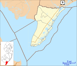
Location map of Cape May County, New Jersey.svg
Red pog.svg
South Dennis
Location in Cape May County
USA New Jersey relief location map.svg
Red pog.svg
South Dennis
Location in New Jersey
Usa edcp relief location map.png
Red pog.svg
South Dennis
Location in the United States
Coordinates: 39°10′42″N74°49′12″W / 39.17833°N 74.82000°W / 39.17833; -74.82000
Country Flag of the United States.svg  United States
State Flag of New Jersey.svg  New Jersey
County Cape May
Township Dennis
Area
[1]
  Total6.28 sq mi (16.27 km2)
  Land6.21 sq mi (16.08 km2)
  Water0.07 sq mi (0.19 km2)
Elevation
[2]
10 ft (3 m)
Population
 (2020) [3]
  Total1,703
  Density274.28/sq mi (105.90/km2)
Time zone UTC−05:00 (Eastern (EST))
  Summer (DST) UTC−04:00 (EDT)
ZIP Code
08245
Area code(s) 609, 640
FIPS code 34-68850 [4]
GNIS feature ID880724 [2]

South Dennis is an unincorporated community located within Dennis Township in Cape May County, in the U.S. state of New Jersey. [5] It is part of the Ocean City Metropolitan Statistical Area. Its postal ZIP Code is 08245. The post office was established in 1873, with Robert Hutchinson as the first postmaster. [6]
Contents

Demographics

Historical population
CensusPop.Note
2020 1,703
U.S. Decennial Census [7]

As of the 2000 United States Census, there were 93 people and 41 households residing in the ZIP Code Tabulation Area 08245. The population density was 930 people per square mile. [8]

Geography

South Dennis is located at 39°10′42″N74°49′12″W / 39.17833°N 74.82000°W / 39.17833; -74.82000 (39.099980, -74.848733). It lies 10 ft (3 m) above sea level. [2] According to the United States Census Bureau, ZIP Code 08245 has a total area of 0.3 km2 (0.1 mi2), all of which is land. [8] Dennis Creek serves as the northern border of the community. [9]

Climate

South Dennis lies on the cusp of a humid subtropical climate zone and experiences four discernible seasons. It receives an average of 44.52 inches (1,131 mm) of precipitation each year, with the wettest season being August. In January 1942, South Dennis experienced its lowest recorded temperature at -22 °F, while the hottest temperature was 103 °F in July 1993. [10]

Climate data for South Dennis, NJ
MonthJanFebMarAprMayJunJulAugSepOctNovDecYear
Average high °F (°C)44
(7)
47
(8)
55
(13)
66
(19)
75
(24)
83
(28)
88
(31)
86
(30)
80
(27)
69
(21)
59
(15)
49
(9)
67
(19)
Average low °F (°C)22
(−6)
24
(−4)
30
(−1)
38
(3)
48
(9)
57
(14)
63
(17)
61
(16)
54
(12)
43
(6)
34
(1)
26
(−3)
42
(5)
Average precipitation inches (mm)3.86
(98)
3.08
(78)
4.18
(106)
3.61
(92)
3.58
(91)
2.88
(73)
3.8
(97)
5.31
(135)
3.76
(96)
3.62
(92)
3.37
(86)
3.47
(88)
44.52
(1,132)
Source: The Weather Channel [10]

Infrastructure

Transportation

Route 83 westbound as it approaches its terminus at Route 47 in 2005 before the intersection was reconstructed to feature a traffic light. Note the 1950s-era curb. Route 83 & Route 47.jpg
Route 83 westbound as it approaches its terminus at Route 47 in 2005 before the intersection was reconstructed to feature a traffic light. Note the 1950s-era curb.

South Dennis lies at the intersection of Route 47 (known as Delsea Drive) and Route 83. [9] A major infrastructure project that realigned Route 47 and added a traffic light was completed in July 2007 at a cost of $6.7 million. [11] Two county routes, County Route 628 and County Route 657, terminate shortly after entering South Dennis. [12] [13]

Fire services

Education

As with other parts of Dennis Township, the area is zoned to Dennis Township Public Schools (for grades K-8) and Middle Township Public Schools (for high school). The latter operates Middle Township High School.

Countywide schools include Cape May County Technical High School and Cape May County Special Services School District.

Notable people

People who were born in, residents of, or otherwise closely associated with South Dennis include:

Related Research Articles

<span class="mw-page-title-main">Berlin Township, New Jersey</span> Township in Camden County, New Jersey, United States

Berlin Township is a township in Camden County, in the U.S. state of New Jersey. As of the 2020 United States census, the township's population was 5,867, an increase of 510 (+9.5%) from the 2010 census count of 5,357, which in turn reflected an increase of 67 (+1.3%) from the 5,290 counted in the 2000 census.

<span class="mw-page-title-main">Avalon, New Jersey</span> Borough in Cape May County, New Jersey, United States

Avalon is a borough in Cape May County, in the U.S. state of New Jersey. It is located on Seven Mile Island. As of the 2020 United States census, the borough's population was 1,243, a decrease of 91 (−6.8%) from the 2010 census count of 1,334, which in turn declined by 809 (−37.8%) from the 2,143 counted in the 2000 census. The borough's population swells to as many as 45,000 during the summer.

<span class="mw-page-title-main">Cape May Court House, New Jersey</span> Populated place in Cape May County, New Jersey, US

Cape May Court House is an unincorporated community and census-designated place (CDP) located within Middle Township in Cape May County, in the U.S. state of New Jersey. It is part of the Ocean City metropolitan statistical area. As of the 2020 United States census, the CDP’s population was 5,573, reflecting a 4.4% increase from the 5,338 enumerated at the 2010 U.S. census, in turn an increase of 13.5% from the 4,704 counted in the 2000 census. It is the county seat of Cape May County and serves as the principal administrative hub for the township. It constitutes part of the greater Philadelphia metropolitan area, or the Delaware Valley.

<span class="mw-page-title-main">Dennis Township, New Jersey</span> Township in Cape May County, New Jersey, United States

Dennis Township is a township in Cape May County, in the U.S. state of New Jersey. The township, and all of Cape May County, is part of the South Jersey region of the state and of the Ocean City metropolitan statistical area, and is part of the Philadelphia-Wilmington-Camden, PA-NJ-DE-MD combined statistical area, also known as the Delaware Valley or Philadelphia metropolitan area. As of the 2020 United States census, the township's population was 6,285, a decrease of 182 (−2.8%) from the 2010 census count of 6,467, which in turn reflected a decline of 25 (−0.4%) from the 6,492 counted in the 2000 census.

<span class="mw-page-title-main">Middle Township, New Jersey</span> Township in Cape May County, New Jersey, United States

Middle Township is a township in Cape May County, in the U.S. state of New Jersey. The township, and all of Cape May County, is part of the Ocean City metropolitan statistical area, and is part of the Philadelphia-Wilmington-Camden, PA-NJ-DE-MD combined statistical area, also known as the Delaware Valley or Philadelphia metropolitan area. As of the 2020 United States census, the township's population was 20,380, an increase of 1,469 (+7.8%) from the 2010 census count of 18,911, which in turn reflected an increase of 2,506 (+15.3%) from the 16,405 counted in the 2000 census. The township's Cape May Court House section is the county seat of Cape May County.

<span class="mw-page-title-main">Rio Grande, New Jersey</span> Place in Cape May County, New Jersey, United States

Rio Grande is an unincorporated community and census-designated place (CDP) located within Middle Township and Lower Township in Cape May County, in the U.S. state of New Jersey.

<span class="mw-page-title-main">Stone Harbor, New Jersey</span> Borough in Cape May County, New Jersey, United States

Stone Harbor is a borough in Cape May County, in the U.S. state of New Jersey. The borough, and all of Cape May County, is part of the South Jersey region of the state and of the Ocean City metropolitan statistical area, which is part of the Philadelphia-Wilmington-Camden, PA-NJ-DE-MD combined statistical area, also known as the Delaware Valley or Philadelphia metropolitan area. It occupies the southern portion of Seven Mile Island together with its northern neighbor Avalon. It is a resort community that attracts visitors looking to enjoy its beaches, sailing facilities and commercial center. The community attracts a large number of vacationers from the Mid-Atlantic region and Quebec.

<span class="mw-page-title-main">Upper Township, New Jersey</span> Township in Cape May County, New Jersey, United States

Upper Township is a large township in Cape May County, in the U.S. state of New Jersey. The township, and all of Cape May County, is part of the South Jersey region of the state and of the Ocean City metropolitan statistical area, which is part of the Philadelphia-Wilmington-Camden, PA-NJ-DE-MD combined statistical area, also known as the Delaware Valley or Philadelphia metropolitan area. As of the 2020 United States census, the township's population was 12,539, an increase of 166 (+1.3%) from the 2010 census count of 12,373, which in turn reflected an increase of 258 (+2.1%) from the 12,115 counted in the 2000 census.

<span class="mw-page-title-main">Woodbine, New Jersey</span> Borough in Cape May County, New Jersey, United States

Woodbine is a borough in Cape May County, in the U.S. state of New Jersey. The borough, and all of Cape May County, is part of the South Jersey region of the state and of the Ocean City metropolitan statistical area, which is part of the Philadelphia-Wilmington-Camden, PA-NJ-DE-MD combined statistical area, also known as the Delaware Valley or Philadelphia metropolitan area. As of the 2020 United States census, the borough's population was 2,128, a decrease of 344 (−13.9%) from the 2010 census count of 2,472, which in turn reflected a decline of 244 (−9.0%) from the 2,716 counted in the 2000 census.

<span class="mw-page-title-main">Washington Township, Gloucester County, New Jersey</span> Township in Gloucester County, New Jersey, United States

Washington Township is a township in Gloucester County, in the U.S. state of New Jersey. As of the 2020 United States census, the township's population was 48,677, an increase of 118 (+0.2%) from the 2010 census count of 48,559, which in turn reflected an increase of 1,445 (3.1%) from the 47,114 counted in the 2000 census. For 2022, the Census Bureau's Population Estimates Program calculated a population of 49,234.

<span class="mw-page-title-main">New Jersey Route 83</span> State highway in Cape May County, New Jersey, US

Route 83 is a state highway in the U.S. state of New Jersey. It is completely within Dennis Township, New Jersey, running 3.81 mi (6.13 km) from an intersection with Route 47 to an intersection with U.S. Route 9 (US 9). The route, which passes through woodland and some residential development, is also known as the Trooper Bertram T. Zimmerman III Memorial Highway in honor of a New Jersey State Police officer who was killed along Route 83 in 2004 while responding to an armed robbery.

<span class="mw-page-title-main">Marmora, New Jersey</span> Populated place in Cape May County, New Jersey, US

Marmora is an unincorporated community and census-designated place (CDP) in Upper Township, in Cape May County, in the U.S. state of New Jersey. It is part of the Ocean City Metropolitan Statistical Area. It is located at 39.258562, -74.659297. Its postal ZIP Code is 08223. Its 1990 population was approximately 4,420 persons.

<span class="mw-page-title-main">Goshen, New Jersey</span> Populated place in Cape May County, New Jersey, US

Goshen is an unincorporated community and census-designated place (CDP) located within Middle Township, in Cape May County, in the U.S. state of New Jersey.

<span class="mw-page-title-main">Middle Township Public Schools</span> School district in Cape May County, New Jersey, United States

The Middle Township Public Schools are a comprehensive community public school district that serves students in kindergarten through twelfth grade from Middle Township, in Cape May County, New Jersey, United States.

<span class="mw-page-title-main">Richland, New Jersey</span> Populated place in Atlantic County, New Jersey, US

Richland is an unincorporated community and census-designated place (CDP) located within Buena Vista Township in Atlantic County, in the U.S. state of New Jersey. The area is served as United States Postal Service ZIP Code 08350.

<span class="mw-page-title-main">Dennisville, New Jersey</span> Populated place in Cape May County, New Jersey, US

Dennisville is an unincorporated community and census-designated place (CDP) located within Dennis Township, in Cape May County, in the U.S. state of New Jersey. It is part of the Ocean City Metropolitan Statistical Area. Its postal ZIP Code is 08214.

<span class="mw-page-title-main">Ocean View, New Jersey</span> Populated place in Cape May County, New Jersey, US

Ocean View is an unincorporated community located within Dennis Township in Cape May County, in the U.S. state of New Jersey. The area is served as United States Postal Service ZIP Code 08230. The post office was established in 1872, with William Doolittle as the first postmaster.

<span class="mw-page-title-main">Belleplain, New Jersey</span> Populated place in Cape May County, New Jersey, US

Belleplain is an unincorporated community and census-designated place (CDP) located within Dennis Township in Cape May County, in the U.S. state of New Jersey. As of the 2010 United States census, the CDP's population was 597.

South Seaville is an unincorporated community located within Dennis Township in Cape May County, in the U.S. state of New Jersey. South Seaville is 4 miles (6.4 km) northwest of Sea Isle City. South Seaville has a post office with ZIP Code 08246.

<span class="mw-page-title-main">Seaville, New Jersey</span> Populated place in Cape May County, New Jersey, US

Seaville is an unincorporated community and census-designated place (CDP) located within Upper Township in Cape May County, in the U.S. state of New Jersey.

References

  1. "ArcGIS REST Services Directory". United States Census Bureau. Retrieved October 11, 2022.
  2. 1 2 3 U.S. Geological Survey Geographic Names Information System: South Dennis, New Jersey. Accessed 4 May 2009.
  3. "Census Population API". United States Census Bureau. Retrieved October 11, 2022.
  4. Geographic Codes Lookup for New Jersey, Missouri Census Data Center. Accessed June 9, 2023.
  5. Locality Search, State of New Jersey. Accessed June 9, 2016.
  6. Stevens, Lewis Townsend (1897). The History of Cape May County, New Jersey: From the Aboriginal Times to the Present Day. Star of the Cape Publishing Co. p. 469.
  7. "Census of Population and Housing". Census.gov. Retrieved June 4, 2016.
  8. 1 2 "08245 zip code South Dennis". BrainyZip. 2009. Retrieved May 4, 2009.
  9. 1 2 Map of South Dennis, New Jersey (Map). Cartography by Tele Atlas. Google Maps. 2009. Retrieved May 5, 2009.
  10. 1 2 "Monthly Weather Averages for South Dennis, New Jersey". The Weather Channel . Retrieved May 10, 2009.
  11. "Dennis Road Project Finally Done". Cape May County Herald . July 25, 2007. Retrieved November 5, 2008.
  12. "County Route 628 Straight Line Diagram" (PDF). New Jersey Department of Transportation . Retrieved May 5, 2009.
  13. "County Route 657 Straight Line Diagram" (PDF). New Jersey Department of Transportation . Retrieved May 5, 2009.
  14. Howe, Paul Sturtevant. Mayflower Pilgrim Descendants in Cape May County, New Jersey, p. 115. A. R. Hand, 1921. Accessed March 15, 2022. "Richard S. Leaming, born at South Dennis, New Jersey, 16 July 1828, died at Dennisville, New Jersey, 25 May 1895."