Tuckahoe, New Jersey

Last updated

Tuckahoe, New Jersey
Tuckahoe Station Cape May.JPG
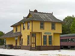
Tuckahoe station, built in 1884 in Tuckahoe
Location map of Cape May County, New Jersey.svg
Red pog.svg
Tuckahoe
Location in Cape May County
USA New Jersey relief location map.svg
Red pog.svg
Tuckahoe
Location in New Jersey
Usa edcp relief location map.png
Red pog.svg
Tuckahoe
Location in the United States
Coordinates: 39°17′24″N74°45′14″W / 39.29000°N 74.75389°W / 39.29000; -74.75389
CountryFlag of the United States.svg  United States
State Flag of New Jersey.svg  New Jersey
County Cape May
Township Upper
Area
[1]
  Total1.04 sq mi (2.70 km2)
  Land1.04 sq mi (2.70 km2)
  Water0.00 sq mi (0.00 km2)
Population
 (2020) [2]
  Total357
  Density342.28/sq mi (132.21/km2)
Time zone UTC−05:00 (Eastern (EST))
  Summer (DST) UTC−04:00 (Eastern (EDT))
ZIP Codes
08250
Area code 609
FIPS code 34-74180 [3]

Tuckahoe is a census-designated place (CDP) [4] unincorporated community located within Upper Township in Cape May County of New Jersey. [5]

Contents

Historical population
CensusPop.Note
2020 357
U.S. Decennial Census [6]

History

The tuckahoe plant was pounded into pulp by local Native Americans and used for cooking and baking, as flour, which served as an ingredient in their cornbread.

Since the tuckahoe was found in great abundance in this area, members of various Lenape tribes would visit this location to collect them.

A bridge, constructed in 1926 and renovated in 1961, connects Tuckahoe to Corbin City, its neighbor to the north. [7] It is also the headquarters for the Cape May Seashore Lines Railroad.

Tuckahoe is named after the wild tuckahoe, which is the sclerotium of the fungus Wolfiporia extensa and sometimes also called Indian Bread, which grew in abundance in this area on the roots of certain trees and was collected by the members of the Lenape tribes in the area.

Roads

Tuckahoe Road, which has its beginnings in Cross Keys, New Jersey at Route 42, provides access to Ocean City at the northern edge of Cape May County and other shore points as an alternative route to the Atlantic City Expressway.

Education

As with other parts of Upper Township, the area is zoned to Upper Township School District (for grades K-8), which sends students to Ocean City High School for grades 9-12.

Countywide schools include Cape May County Technical High School and Cape May County Special Services School District.

See also

Related Research Articles

<span class="mw-page-title-main">Cape May County, New Jersey</span> County in New Jersey, United States

Cape May County is the southernmost county in the U.S. state of New Jersey. Much of the county is located on the Cape May peninsula, bound by the Delaware Bay to its west and the Atlantic Ocean to its south and east. Adjacent to the Atlantic coastline are five barrier islands that have been built up as seaside resorts. A consistently popular summer destination with 30 miles (48 km) of beaches, Cape May County attracts vacationers from New Jersey and surrounding states, with the summer population exceeding 750,000. Tourism generates annual revenues of about $6.6 billion as of 2018, making it the county's single largest industry. The associated leisure and hospitality industries are Cape May's largest employers. Its county seat is the Cape May Court House section of Middle Township. The county is part of the Jersey Shore region of the state.

<span class="mw-page-title-main">Atlantic County, New Jersey</span> County in New Jersey, United States

Atlantic County is a county located along the Jersey Shore in the U.S. state of New Jersey. As of the 2020 census, the county was the state's 15th-most-populous county, with a population of 274,534, a drop of 15 from the 2010 census count of 274,549. Its county seat is the Mays Landing section of Hamilton Township. The county is part of the Jersey Shore region of the state.

<span class="mw-page-title-main">New Jersey Route 50</span> State highway in southern, New Jersey, US

Route 50 is a state highway in the southern part of the U.S. state of New Jersey. It runs 26.02 mi (41.88 km) from an intersection with U.S. Route 9 and the Garden State Parkway in Upper Township, Cape May County, north to an intersection with US 30 and County Route 563 in Egg Harbor City, Atlantic County. The route, which is mostly a two-lane undivided road, passes through mostly rural areas of Atlantic and Cape May counties as well as the communities of Tuckahoe, Corbin City, Estell Manor, and Mays Landing. Route 50 intersects several roads, including Route 49 in Tuckahoe, US 40 in Mays Landing, and US 322 and the Atlantic City Expressway in Hamilton Township.

<span class="mw-page-title-main">Corbin City, New Jersey</span> City in Atlantic County, New Jersey, United States

Corbin City is a city in Atlantic County, in the U.S. state of New Jersey. The city, and all of Atlantic County, is part of the Atlantic City-Hammonton metropolitan statistical area, which in turn is included in the Philadelphia-Reading-Camden combined statistical area and the Delaware Valley. As of the 2020 United States census, the city's population was 471, a decrease of 21 (−4.3%) from the 2010 census count of 492, which in turn reflected an increase of 24 (+5.1%) from the 468 counted in the 2000 census.

<span class="mw-page-title-main">Egg Harbor Township, New Jersey</span> Township in Atlantic County, New Jersey, United States

Egg Harbor Township is a township in Atlantic County, in the U.S. state of New Jersey. As of the 2020 United States census, the township's population was 47,842, its highest decennial count ever and an increase of 4,519 (+10.4%) from the 2010 census count of 43,323, which in turn reflected an increase of 12,597 (+41.0%) from the 30,726 counted in the 2000 census.

<span class="mw-page-title-main">Dennis Township, New Jersey</span> Township in Cape May County, New Jersey, United States

Dennis Township is a township in Cape May County, in the U.S. state of New Jersey. The township, and all of Cape May County, is part of the South Jersey region of the state and of the Ocean City metropolitan statistical area, and is part of the Philadelphia-Wilmington-Camden, PA-NJ-DE-MD combined statistical area, also known as the Delaware Valley or Philadelphia metropolitan area. As of the 2020 United States census, the township's population was 6,285, a decrease of 182 (−2.8%) from the 2010 census count of 6,467, which in turn reflected a decline of 25 (−0.4%) from the 6,492 counted in the 2000 census.

<span class="mw-page-title-main">Lower Township, New Jersey</span> Township in Cape May County, New Jersey, United States

Lower Township is a township in Cape May County, in the U.S. state of New Jersey. The township, and all of Cape May County, is part of the Ocean City metropolitan statistical area, and is part of the Philadelphia-Wilmington-Camden, PA-NJ-DE-MD combined statistical area, also known as the Delaware Valley or Philadelphia metropolitan area. As of the 2020 United States census, the township's population was 22,057, a decrease of 809 (−3.5%) from the 2010 census count of 22,866, which in turn reflected a decrease of 79 (−0.3%) from the 22,945 counted in the 2000 census.

<span class="mw-page-title-main">Middle Township, New Jersey</span> Township in Cape May County, New Jersey, United States

Middle Township is a township in Cape May County, in the U.S. state of New Jersey. The township, and all of Cape May County, is part of the Ocean City metropolitan statistical area, and is part of the Philadelphia-Wilmington-Camden, PA-NJ-DE-MD combined statistical area, also known as the Delaware Valley or Philadelphia metropolitan area. As of the 2020 United States census, the township's population was 20,380, an increase of 1,469 (+7.8%) from the 2010 census count of 18,911, which in turn reflected an increase of 2,506 (+15.3%) from the 16,405 counted in the 2000 census. The township's Cape May Court House section is the county seat of Cape May County.

<span class="mw-page-title-main">Ocean City, New Jersey</span> City in Cape May County, New Jersey, United States

Ocean City is a city in Cape May County, in the U.S. state of New Jersey. It is the principal city of the Ocean City metropolitan statistical area, which encompasses all of Cape May County, and is part of the Philadelphia-Wilmington-Camden, PA-NJ-DE-MD combined statistical area, also known as the Delaware Valley or Philadelphia metropolitan area. It is part of the South Jersey region of the state.

<span class="mw-page-title-main">Rio Grande, New Jersey</span> Place in Cape May County, New Jersey, United States

Rio Grande is an unincorporated community and census-designated place (CDP) located within Middle Township and Lower Township in Cape May County, in the U.S. state of New Jersey.

<span class="mw-page-title-main">Sea Isle City, New Jersey</span> City in Cape May County, New Jersey, United States

Sea Isle City is a city in Cape May County, in the U.S. state of New Jersey. The city, and all of Cape May County, is part of the South Jersey region of the state and of the Ocean City metropolitan statistical area, and is part of the Philadelphia-Wilmington-Camden, PA-NJ-DE-MD combined statistical area, also known as the Delaware Valley or Philadelphia metropolitan area. As of the 2020 United States census, the city's year-round population was 2,104, a decrease of 10 (−0.5%) from the 2010 census count of 2,114, which in turn reflected a decline of 721 (−25.4%) from the 2,835 counted in the 2000 census. Visitors raise the population to as much as 40,000 during the peak summer season from Memorial Day to Labor Day. Sea Isle City is located on Ludlam Island, which also contains the Strathmere section of Upper Township.

<span class="mw-page-title-main">Strathmere, New Jersey</span> Populated place in Cape May County, New Jersey, US

Strathmere is an unincorporated community and census-designated place (CDP) located within Upper Township in Cape May County, in the U.S. state of New Jersey. As of the 2020 United States census, the CDP's population was 137, a decrease of 21 (−13.3%) from the 158 counted at the 2010 U.S. census, which reflected a decrease of 17 (−9.7%) from the 175 enumerated at the 2000 census.

<span class="mw-page-title-main">Upper Township, New Jersey</span> Township in Cape May County, New Jersey, United States

Upper Township is a large township in Cape May County, in the U.S. state of New Jersey. The township, and all of Cape May County, is part of the South Jersey region of the state and of the Ocean City metropolitan statistical area, which is part of the Philadelphia-Wilmington-Camden, PA-NJ-DE-MD combined statistical area, also known as the Delaware Valley or Philadelphia metropolitan area. As of the 2020 United States census, the township's population was 12,539, an increase of 166 (+1.3%) from the 2010 census count of 12,373, which in turn reflected an increase of 258 (+2.1%) from the 12,115 counted in the 2000 census.

<span class="mw-page-title-main">Manahawkin, New Jersey</span> Populated place in Ocean County, New Jersey, US

Manahawkin is an unincorporated community and census-designated place (CDP) located within Stafford Township, in Ocean County, in the U.S. state of New Jersey. As of the 2020 United States census, the CDP's population was 2,413, its highest decennial count ever and an increase of 110 (+4.8%) from the 2,303 recorded at the 2010 census, which in turn had reflected an increase of 299 (+14.9%) from the 2,004 counted at the 2000 census. Manahawkin has been thought to be a Lenape word meaning "land of good corn", although this has been disputed by recent scholars claiming that it translates to "fertile land sloping into the water."

<span class="mw-page-title-main">Marmora, New Jersey</span> Populated place in Cape May County, New Jersey, US

Marmora is an unincorporated community and census-designated place (CDP) in Upper Township, in Cape May County, in the U.S. state of New Jersey. It is part of the Ocean City Metropolitan Statistical Area. Its postal ZIP Code is 08223. Its 1990 population was approximately 4,420 persons.

<span class="mw-page-title-main">Ocean View, New Jersey</span> Populated place in Cape May County, New Jersey, US

Ocean View is an unincorporated community and census-designated place (CDP) located within Dennis Township in Cape May County, in the U.S. state of New Jersey. The area is served as United States Postal Service ZIP Code 08230. The post office was established in 1872, with William Doolittle as the first postmaster.

<span class="mw-page-title-main">Beesley's Point, New Jersey</span> Populated place in Cape May County, New Jersey, US

Beesley's Point is an unincorporated community and census-designated place (CDP) in Upper Township, in Cape May County, in the U.S. state of New Jersey. Beesley's Point is on Peck Bay across from Ocean City. Beesley's Point is home to the Beesley's Point Generating Station and one end of the now-closed Beesley's Point Bridge.

Palermo is an unincorporated community and census-designated place (CDP) located in Upper Township, in Cape May County, in the U.S. state of New Jersey.

<span class="mw-page-title-main">Seaville, New Jersey</span> Populated place in Cape May County, New Jersey, US

Seaville is an unincorporated community and census-designated place (CDP) located within Upper Township in Cape May County, in the U.S. state of New Jersey.

Marshallville is an unincorporated community and census-designated place (CDP) located in Upper Township, Cape May County, in the U.S. state of New Jersey. It is on the northern edge of the county, bordered to the north, across the Tuckahoe River, by Corbin City in Atlantic County. It is bordered to the east by the unincorporated community of Tuckahoe.

References

  1. "ArcGIS REST Services Directory". United States Census Bureau. Retrieved October 11, 2022.
  2. "Census Population API". United States Census Bureau. Retrieved October 11, 2022.
  3. Geographic Codes Lookup for New Jersey, Missouri Census Data Center. Accessed June 9, 2023.
  4. State of New Jersey Census Designated Places - BVP20 - Data as of January 1, 2020, United States Census Bureau. Accessed December 1, 2022.
  5. Locality Search, State of New Jersey. Accessed June 9, 2016.
  6. "Census of Population and Housing". Census.gov. Retrieved June 4, 2016.
  7. Historic American Engineering Record (HAER) No. NJ-89, "State Route 50 Bascule Bridge"