Belleplain, New Jersey

Last updated

Belleplain, New Jersey
CR 550 wb approaching CR 605, July 2021.jpg
Center of Belleplain on County Route 550
Location map of Cape May County, New Jersey.svg
Red pog.svg
Belleplain
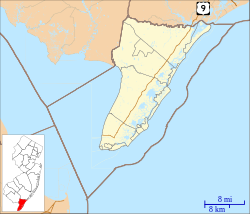
Belleplain's location in Cape May County. Inset: Location of Cape May County in New Jersey.
USA New Jersey location map.svg
Red pog.svg
Belleplain
Belleplain (New Jersey)
Usa edcp location map.svg
Red pog.svg
Belleplain
Belleplain (the United States)
Coordinates: 39°15′37″N74°52′25″W / 39.260327°N 74.873714°W / 39.260327; -74.873714
Country Flag of the United States.svg  United States
State Flag of New Jersey.svg  New Jersey
County Cape May
Township Dennis
Area
[1]
  Total7.35 sq mi (19.04 km2)
  Land7.34 sq mi (19.01 km2)
  Water0.01 sq mi (0.03 km2)  0.15%
Elevation
[2]
43 ft (13 m)
Population
 (2020) [3]
  Total614
  Density83.66/sq mi (32.30/km2)
Time zone UTC−05:00 (Eastern (EST))
  Summer (DST) UTC−04:00 (Eastern (EDT))
ZIP Code
08270 - Woodbine [4]
Area code 609
FIPS code 3404660 [5] [6] [7]
GNIS feature ID02629044 [5] [8]

Belleplain is an unincorporated community and census-designated place (CDP) [9] located within Dennis Township in Cape May County, in the U.S. state of New Jersey. [10] As of the 2010 United States census, the CDP's population was 597. [11]
Contents

Geography

According to the United States Census Bureau, Belleplain had a total area of 7.405 square miles (19.178 km2), including 7.394 square miles (19.150 km2) of land and 0.011 square miles (0.029 km2) of water (0.15%). [5] [12]

Demographics

Historical population
CensusPop.Note
2010 597
2020 6142.8%
Population sources: 2010 [11] [3]

2010 census

The 2010 United States census counted 597 people, 218 households, and 171 families in the CDP. The population density was 80.7 per square mile (31.2/km2). There were 230 housing units at an average density of 31.1 per square mile (12.0/km2). The racial makeup was 95.48% (570) White, 0.67% (4) Black or African American, 0.34% (2) Native American, 0.17% (1) Asian, 0.00% (0) Pacific Islander, 1.01% (6) from other races, and 2.35% (14) from two or more races. Hispanic or Latino of any race were 3.18% (19) of the population. [11]

Of the 218 households, 26.6% had children under the age of 18; 61.0% were married couples living together; 11.0% had a female householder with no husband present and 21.6% were non-families. Of all households, 16.1% were made up of individuals and 8.3% had someone living alone who was 65 years of age or older. The average household size was 2.74 and the average family size was 3.02. [11]

21.8% of the population were under the age of 18, 7.7% from 18 to 24, 24.1% from 25 to 44, 31.5% from 45 to 64, and 14.9% who were 65 years of age or older. The median age was 41.8 years. For every 100 females, the population had 97.0 males. For every 100 females ages 18 and older there were 98.7 males. [11]

Education

As with other parts of Dennis Township, the area is zoned to Dennis Township Public Schools (for grades K-8) and Middle Township Public Schools (for high school). The latter operates Middle Township High School.

Countywide schools include Cape May County Technical High School and Cape May County Special Services School District.

Related Research Articles

<span class="mw-page-title-main">Cape May Court House, New Jersey</span> Populated place in Cape May County, New Jersey, US

Cape May Court House is an unincorporated community and census-designated place (CDP) located within Middle Township in Cape May County, in the U.S. state of New Jersey. It is part of the Ocean City metropolitan statistical area. As of the 2020 United States census, the CDP’s population was 5,573, reflecting a 4.4% increase from the 5,338 enumerated at the 2010 U.S. census, in turn an increase of 13.5% from the 4,704 counted in the 2000 census. It is the county seat of Cape May County and serves as the principal administrative hub for the township. It constitutes part of the greater Philadelphia metropolitan area, or the Delaware Valley.

<span class="mw-page-title-main">Dennis Township, New Jersey</span> Township in Cape May County, New Jersey, United States

Dennis Township is a township in Cape May County, in the U.S. state of New Jersey. The township, and all of Cape May County, is part of the South Jersey region of the state and of the Ocean City metropolitan statistical area, and is part of the Philadelphia-Wilmington-Camden, PA-NJ-DE-MD combined statistical area, also known as the Delaware Valley or Philadelphia metropolitan area. As of the 2020 United States census, the township's population was 6,285, a decrease of 182 (−2.8%) from the 2010 census count of 6,467, which in turn reflected a decline of 25 (−0.4%) from the 6,492 counted in the 2000 census.

<span class="mw-page-title-main">Diamond Beach, New Jersey</span> Populated place in Cape May County, New Jersey, US

Diamond Beach is an unincorporated community and census-designated place (CDP) located within Lower Township in Cape May County, in the U.S. state of New Jersey. The CDP, and all of Cape May County, is part of the Ocean City metropolitan statistical area, and is part of the Philadelphia-Wilmington-Camden, PA-NJ-DE-MD combined statistical area, also known as the Delaware Valley or Philadelphia metropolitan area. As of the United States 2020 Census, the CDP's population was 203, an increase of 67 from the 2010 census count of 136.

<span class="mw-page-title-main">Erma, New Jersey</span> Populated place in Cape May County, New Jersey, US

Erma is an unincorporated community and census-designated place (CDP) located within Lower Township in Cape May County, in the U.S. state of New Jersey. As of the 2020 United States census, the CDP's population was 2,031, a decline of 103 from the 2010 census count of 2,134.

<span class="mw-page-title-main">North Cape May, New Jersey</span> Census-designated place in New Jersey, United States

North Cape May is an unincorporated community and census-designated place (CDP) located within Lower Township in Cape May County, in the U.S. state of New Jersey. It is part of the Ocean City Metropolitan Statistical Area. At the 2010 United States Census, the CDP's population was 3,226. The Cape May–Lewes Ferry departs from the area. North Cape May is mostly a residential community, with no hotels but many vacation homes. Many people retire to the community.

<span class="mw-page-title-main">Rio Grande, New Jersey</span> Place in Cape May County, New Jersey, United States

Rio Grande is an unincorporated community and census-designated place (CDP) located within Middle Township and Lower Township in Cape May County, in the U.S. state of New Jersey.

<span class="mw-page-title-main">Strathmere, New Jersey</span> Populated place in Cape May County, New Jersey, US

Strathmere is an unincorporated community and census-designated place (CDP) located within Upper Township in Cape May County, in the U.S. state of New Jersey. As of the 2020 United States census, the CDP's population was 137, a decrease of 21 (−13.3%) from the 158 counted at the 2010 U.S. census, which reflected a decrease of 17 (−9.7%) from the 175 enumerated at the 2000 census.

<span class="mw-page-title-main">Villas, New Jersey</span> Place in Cape May County, New Jersey, United States

Villas, also known as the Villas, is an unincorporated community and census-designated place (CDP) located within Lower Township, in Cape May County, in the U.S. state of New Jersey. The locality is also home to the community of Miami Beach. At the 2010 census, the CDP's population was 9,483.

<span class="mw-page-title-main">Fords, New Jersey</span> Populated place in Middlesex County, New Jersey, US

Fords is an unincorporated community and census-designated place (CDP) located within Woodbridge Township, in Middlesex County, in the U.S. state of New Jersey. As of the 2010 United States Census, the CDP's population was 15,187.

<span class="mw-page-title-main">Old Bridge (CDP), New Jersey</span> Census-designated place in New Jersey, United States

Old Bridge is a census-designated place (CDP) in Old Bridge Township, in Middlesex County, in the U.S. state of New Jersey. As of the 2010 United States Census, the CDP's population was 23,753. Despite the similarity in the name of the CDP and the township, the two are not one and the same, as had been the case for most paired Township / CDP combinations prior to the 2010 Census, in which the CDP was coextensive with a township of the same name.

<span class="mw-page-title-main">Morganville, New Jersey</span> Populated place in Monmouth County, New Jersey, US

Morganville is an unincorporated community and census-designated place (CDP) within Marlboro Township, in Monmouth County, New Jersey. As of the 2010 United States Census, the CDP's population was 5,040.

<span class="mw-page-title-main">Shark River Hills, New Jersey</span> Census-designated place in New Jersey, United States

Shark River Hills is an unincorporated community and census-designated place (CDP) within Neptune Township, in Monmouth County, in the U.S. state of New Jersey. As of the 2010 United States Census, the CDP's population was 3,697.

<span class="mw-page-title-main">White Meadow Lake, New Jersey</span> Census-designated place in New Jersey, United States

White Meadow Lake is an unincorporated community and census-designated place (CDP) located within Rockaway Township, in Morris County, in the U.S. state of New Jersey. As of the 2010 United States Census, the CDP's population was 8,836.

<span class="mw-page-title-main">Leisure Village East, New Jersey</span> Census-designated place in New Jersey, United States

Leisure Village East is an unincorporated community and census-designated place (CDP) located within Lakewood Township, in Ocean County, in the U.S. state of New Jersey. As of the 2010 United States Census, the CDP's population was 4,217. Leisure Village East is one of several active adult communities bearing similar names. Leisure Village and Leisure Village West are the other two communities nearby.

<span class="mw-page-title-main">Ramtown, New Jersey</span> Census-designated place in New Jersey, United States

Ramtown is a census-designated place and unincorporated community located within Howell Township, in Monmouth County, in the U.S. state of New Jersey. As of the 2010 United States Census, the CDP's population was 6,242.

<span class="mw-page-title-main">Whitesboro, New Jersey</span> Census-designated place in New Jersey, United States

Whitesboro is an unincorporated community and census-designated place (CDP) located within Middle Township in Cape May County, in the U.S. state of New Jersey. Until the 2000 census the area had been part of the Whitesboro-Burleigh CDP, which was split in 2010 into separate CDPs for Burleigh and Whitesboro. As of the 2010 United States Census, the CDP's population was 2,205. Whitesboro was founded as a planned residential community for African Americans and has the majority of the township's black population.

<span class="mw-page-title-main">Robbinsville (CDP), New Jersey</span> Census-designated place in New Jersey, United States

Robbinsville is a census-designated place (CDP) located within Robbinsville Township in Mercer County, in the U.S. state of New Jersey. The area is served as United States Postal Service ZIP Code 08691. As of the 2010 United States Census, the population for the CDP was 3,041.

<span class="mw-page-title-main">Yardville, New Jersey</span> Census-designated place in New Jersey, United States

Yardville is an unincorporated community and census-designated place (CDP) located within Hamilton Township, in Mercer County, in the U.S. state of New Jersey. As of the 2010 United States Census, the CDP's population was 2,945. Before the 2010 Census, the area was part of the Yardville-Groveville CDP.

<span class="mw-page-title-main">Burleigh, New Jersey</span> Populated place in Cape May County, New Jersey, US

Burleigh is an unincorporated community and census-designated place (CDP) located within Middle Township in Cape May County, in the U.S. state of New Jersey; Until the 2000 census the area had been part of the Whitesboro-Burleigh CDP, which was split in 2010 into separate CDPs for Burleigh and Whitesboro. As of the 2010 United States Census, the CDP's population was 725.

<span class="mw-page-title-main">Robertsville, New Jersey</span> Census-designated place in New Jersey, United States

Robertsville is a census-designated place and unincorporated community located within Marlboro Township, in Monmouth County, New Jersey, United States. At the 2010 census, the CDP's population was 11,297.

References

  1. "ArcGIS REST Services Directory". United States Census Bureau. Retrieved October 11, 2022.
  2. U.S. Geological Survey Geographic Names Information System: Belleplain Census Designated Place, Geographic Names Information System. Accessed October 18, 2012.
  3. 1 2 "Census Population API". United States Census Bureau. Retrieved October 11, 2022.
  4. Look Up a ZIP Code for Belleplain, NJ, United States Postal Service. Accessed October 18, 2012.
  5. 1 2 3 Gazetteer of New Jersey Places, United States Census Bureau. Accessed July 21, 2016.
  6. U.S. Census website, United States Census Bureau. Accessed September 4, 2014.
  7. Geographic Codes Lookup for New Jersey, Missouri Census Data Center. Accessed June 9, 2023.
  8. US Board on Geographic Names, United States Geological Survey. Accessed September 4, 2014.
  9. State of New Jersey Census Designated Places - BVP20 - Data as of January 1, 2020, United States Census Bureau. Accessed December 1, 2022.
  10. New Jersey: 2010 - Population and Housing Unit Counts - 2010 Census of Population and Housing (CPH-2-32), United States Census Bureau, August 2012. Accessed October 18, 2012.
  11. 1 2 3 4 5 DP-1 - Profile of General Population and Housing Characteristics: 2010 Demographic Profile Data for Belleplain CDP, New Jersey Archived 2020-02-12 at archive.today , United States Census Bureau. Accessed October 18, 2012.
  12. US Gazetteer files: 2010, 2000, and 1990, United States Census Bureau. Accessed September 4, 2014.