Fishermans Bend, Victoria

Last updated

Fishermans Bend
Melbourne,  Victoria
Port of Melbourne sign.jpg
Australia Victoria metropolitan Melbourne location map.svg
Red pog.svg
Fishermans Bend
Coordinates 37°49′36″S144°55′02″E / 37.826667°S 144.917221°E / -37.826667; 144.917221
Established1835
Postcode(s) 3207
Area1.5 km2 (0.6 sq mi)
Location1 km (1 mi) south of Melbourne CBD
LGA(s) Municipality of Port Phillip
State electorate(s) Albert Park
Federal division(s) Macnamara
Localities around Fishermans Bend:
Yarraville West Melbourne Melbourne
Yarraville Fishermans Bend South Melbourne
Williamstown Port Melbourne South Melbourne

Fishermans Bend (formerly Fishermen's Bend) is a precinct within the City of Port Phillip and the City of Melbourne. It is located on the south of the Yarra River in the suburb of Port Melbourne and opposite Coode Island, close to the Melbourne central business district. Fishermans Bend originally included the area now known as Garden City, which was renamed in 1929. [1]

Contents

Since 2012 the area has been designated as a major urban renewal area, with plans for 80,000 residents by 2050. [2] The future framework for Fishermans Bend includes one major employment precinct and four primarily residential suburbs. [3]

Early settlement

Fishermen began settling 'Humbug Reach' and 'Fishermen's Bend' along the lower Yarra River in the 1850s. Thirty families lived on the 'Bend', frequently finding additional work in the docks and cargo ships and loading ballast for ships returning to Europe. Habitation was in rough shacks along the Bend, made from corrugated iron, flattened kerosene tins or wood. There were no roads, shops, or sewerage. Water was collected from hanging out sail canvases, and stored in iron tanks or casks. Milk came from a nearby farm. Fishing continues on the bay. The last remaining shack on the Bend was demolished in 1970, as Webb Dock expanded; the Life Saving Victoria headquarters stand on the site today. [4]

Industry

RAAF Bristol Beaufort Mk.V torpedo bombers at the Department of Aircraft Production (DAP) plant in Fisherman's Bend, circa 1941. RAAF Beauforts DAP Melbourne.jpg
RAAF Bristol Beaufort Mk.V torpedo bombers at the Department of Aircraft Production (DAP) plant in Fisherman's Bend, circa 1941.
Prime Minister of Australia Ben Chifley at the launching of the first mass-produced Australian car at the General Motors-Holden factory, Fisherman's Bend. Chifley Holden Launch.jpg
Prime Minister of Australia Ben Chifley at the launching of the first mass-produced Australian car at the General Motors-Holden factory, Fisherman's Bend.

The neighbourhood of Fishermans Bend also has a significant place in Australian aviation history, being the home of several prominent historical Australian aircraft design and manufacturing companies, including the Commonwealth Aircraft Corporation, Holden, Smorgon Steel, Government Aircraft Factories, the Aeronautical Research Laboratories and regional facilities for Boeing. Fishermen's Bend Aerodrome remained in use until 1957. [5]

Previous industries included the car manufacturers Australian Motor Industries (Later Toyota Australia) and the Rootes Group, GKN Aerospace Engineering Services and a campus of RMIT University dedicated to aerospace engineering.

Fishermans Bend is a primarily industrial centre at the foot of the West Gate Bridge and contains major establishments for the Defence Science and Technology Organisation, Holden, Hawker de Havilland, the Cooperative Research Centre for Advanced Composite Structures, Kraft Foods, Specsavers, Toyota Australia, and port security. It also has a marina, known as d'Albora Marinas Pier 35, and the Webb Dock container terminal. Fishermans Bend has a single large reserve known as Westgate Park, a large artificial wetland.

Redevelopment

2012 rezoning

In 2012, then-Planning Minister Matthew Guy under the State Government of Ted Baillieu made a surprise decision to rezone 250 hectares of Fishermans Bend from urban industrial land to mixed use, placing the area as part of Melbourne's Capital City Zone. [6] This move was highly controversial, as it led to a large increase in property prices for current land-owners before the provision of any public services or infrastructure. [7] [8] The rezoning delivered significant profits to land-owners in the area, including senior members of the Liberal Party. [9] [10] [11] In the three years following the rezoning, 68 development applications for office and residential buildings were made, 46 of which were between 20 and 64 storeys high. [11]

The Age newspaper reported in 2014 that the rezoning cost the State Government up to $330 million to buy private land to convert to land for public parks and other public uses. [7] A 2015 report by an expert advisory committee appointed by Guy's Labor successor Richard Wynne found the rezoning lacked a clear rationale, lacked sufficient planning, and occurred before the State had developed a strategy for transport, local services or infrastructure. [12] The committee report labelled the rezoning as "unprecedented in the developed world in the 21st century". [13] The report argued:

The rezoning mistakenly assumed that the development of an urban renewal area could be managed by the exercise of the same controls and processes as the rest of the Capital City Zone which applies to the ‘Hoddle Grid’ and Southbank where there is a strong Municipal Strategic Statement, existing statutory design and development planning overlay controls, and where public transport, roads, open space, heritage overlays and building form are all in place. None of these factors applied in the Fishermans Bend Urban Renewal Area at the time of the rezoning. [13]

In 2015 the State Government paid $30 million for a small industrial site on Buckhurst Street in Fishermans Bend to create a public park, five times its value eight years prior. [14]

Urban renewal framework

Map showing the new precincts in Fishermans Bend Fishermans Bend Melbourne Precinct Names 2018.png
Map showing the new precincts in Fishermans Bend
Map showing the height controls mandated in the 2018 Fishermans Bend Framework Fishermans Bend Melbourne Height Controls 2018.png
Map showing the height controls mandated in the 2018 Fishermans Bend Framework

Following the 2014 Victorian state election in 2015 the new Labor State Government introduced interim planning controls, seeking to reset the planning approach to the precinct. [15] The Government expanded the Fishermans Bend regeneration area to include the City of Melbourne's industrial precinct along the river's edge, bringing the total urban renewal area to 480 hectares. [11] In early 2018 the State Government put a hold on all development applications in the precinct until permanent planning controls were put in place, citing the height of proposed developments. [16] [17]

In 2017 the University of Melbourne announced it was building an advanced manufacturing, engineering and design campus in the Fishermans Bend Employment Precinct. [18] Stage one of the new campus is set to open in 2026. [18] The University spent $49.8 million to buy seven hectares in the precinct, in the old General Motors Holden site. [18]

After a public engagement process, a new planning framework and strategy for Fishermans Bend was released in October 2018. [3] [19] The plan introduced new planning controls, restricted building heights, mandated building set-backs and articulated the location of future open space, schools and public transport. [3] [19] [2] It defined the creation of five new suburbs in Fishermans Bend:

The Framework aimed for 80,000 jobs and 80,000 residents in the area by 2050. [19]

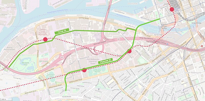
Along with new planning controls, the 2018 Framework proposed two tram lines through Fishermans Bend: one running through the new suburbs of Sandridge and Wirraway along Plummer Street, and the other running through Lorimer and the Employment Precinct along Turner Street. [3] The Framework gives a 'medium term' delivery timeframe of 2020-2025, while Infrastructure Australia also identified the project as a 'medium term' priority. [20] The 2019-2020 state budget allocated $4.5 million to plan the tram routes to Fishermans Bend and develop a preliminary business case for the project. [21]

The Framework also outlined two possible options for metro stations as part of the proposed Melbourne Metro 2 tunnel, which would connect the Werribee line with the Mernda line through a new underground rail link. [3] After the release of the plan, industry figures and some media outlets called for funding for the proposed public transport links. [22] [23]

Map showing the two proposed extensions of the tram network through Fishermans Bend and two options for the proposed metro rail tunnel, according to the State Government's 2018 framework. Fishermans Bend Tram and Metro Proposal 2019.jpg
Map showing the two proposed extensions of the tram network through Fishermans Bend and two options for the proposed metro rail tunnel, according to the State Government's 2018 framework.


Related Research Articles

<span class="mw-page-title-main">Trams in Melbourne</span> Tramway network in Melbourne, Victoria, Australia

Trams are a major form of public transport in Melbourne, the capital city of the state of Victoria, Australia. As of May 2017, the Melbourne tramway network consists of 250 kilometres of double track, 493 trams, 24 routes, and 1,763 tram stops. The system is the largest operational urban tram network in the world. Trams are the second most used form of public transport in overall boardings in Melbourne after the commuter railway network, with a total of 206 million passenger trips in 2017–18.

<span class="mw-page-title-main">Docklands, Victoria</span> Suburb of Melbourne, Victoria, Australia

Docklands, also known as Melbourne Docklands, is an inner-city suburb in Melbourne, Victoria, Australia, 2 km (1.2 mi) west of Melbourne's Central Business District, located within the City of Melbourne local government area. Docklands recorded a population of 15,495 at the 2021 census.

<span class="mw-page-title-main">Port Melbourne</span> Suburb of Melbourne, Victoria, Australia

Port Melbourne is an inner-city suburb in Melbourne, Victoria, Australia, 3 km (2 mi) south-west of the Melbourne central business district, located within the Cities of Melbourne and Port Phillip local government areas. Port Melbourne recorded a population of 17,633 at the 2021 census.

<span class="mw-page-title-main">Proposed Melbourne rail extensions</span> Extensions to the Melbourne rail network

Proposals for expansion of the Melbourne rail network are commonly presented by political parties, government agencies, industry organisations and public transport advocacy groups. The extensions proposed take a variety of forms: electrification of existing routes to incorporate them into the suburban rail system; reconstruction of former passenger rail lines along pre-existing easements; entirely new routes intended to serve new areas with heavy rail or provide alternative routes in congested areas; or track amplification along existing routes to provide segregation of services. Other proposals are for the construction of new or relocated stations on existing lines, to provide improved access to public transport services.

<span class="mw-page-title-main">Eastern Freeway (Melbourne)</span>

The Eastern Freeway is an urban freeway in eastern Melbourne, the state capital of Victoria, Australia. It is one of the most important freeways in terms of commuting to the city, connecting Alexandra Parade and Hoddle Street in the inner suburbs, with EastLink tollway farther east. It consists of between three and six lanes in each direction, also an inbound transit lane reserved for vehicles with two or more occupants during peak hours.

<span class="mw-page-title-main">Transport in Melbourne</span> Overview of transport in Melbourne, Victoria, Australia

Transport in Melbourne, the state capital of Victoria, Australia, consists of several interlinking modes. Melbourne is a hub for intercity, intracity and regional travel. Road-based transport accounts for most trips across many parts of the city, facilitated by Australia's largest freeway network. Public transport, including the world's largest tram network, trains and buses, also forms a key part of the transport system. Other dominant modes include walking, cycling and commercial-passenger vehicle services such as taxis.

<span class="mw-page-title-main">Melbourne 2030</span>

Melbourne 2030 is a Government of Victoria strategic planning policy framework for the metropolitan area of Melbourne, Australia intended to cover the period 2001–2030. During this period the population of the metropolitan area is expected to grow by a million people to over five million. Population projections now predict Melbourne's population could reach seven million by that time and the government has since changed its strategy on the policy, abandoning the urban growth boundary in the north and west of Melbourne and reducing green wedges.

Matthew Jason Guy is an Australian politician. He has been a Liberal Party member of the Parliament of Victoria since 2006, representing the Northern Metropolitan Region in the Legislative Council (2006–2014) and Bulleen in the Legislative Assembly (2014–present). He was Leader of the Opposition in Victoria and state leader of the Liberal Party from 2014 to 2018, when he resigned the leadership after the Liberal Party's landslide defeat in the 2018 Victorian election. From 7 September 2021, Guy again served as Leader of the Opposition and Leader of the Liberal Party in Victoria, but he again resigned after another heavy defeat in the 2022 state election.

<span class="mw-page-title-main">Melbourne</span> Capital city of Victoria, Australia

Melbourne is the coastal capital of the Australian state of Victoria, and the second-most populous city in Australia. Its name generally refers to a 9,993 km2 (3,858 sq mi) metropolitan area known as Greater Melbourne, comprising an urban agglomeration of 31 local municipalities, although the name is also used specifically for the local municipality of City of Melbourne based around its central business area. The metropolis occupies much of the northern and eastern coastlines of Port Phillip Bay and spreads into the Mornington Peninsula, part of West Gippsland, as well as the hinterlands towards the Yarra Valley, the Dandenong and Macedon Ranges. It has a population over 5 million, mostly residing to the east side of the city centre, and its inhabitants are commonly referred to as "Melburnians".

<span class="mw-page-title-main">Metro Tunnel</span> Underground rapid transit project in Melbourne, Australia

The Metro Tunnel is a metropolitan rail rapid transit project currently under construction in Melbourne, Victoria, Australia. It includes the construction of twin 9-kilometre (5.6 mi) rail tunnels between South Kensington and South Yarra with five new underground stations. The tunnel will connect the Pakenham and Cranbourne lines with the Sunbury line, creating a new cross-city line that bypasses Flinders Street station and the City Loop. The line is also planned to serve Melbourne Airport via a new branch line west of Sunshine station.

Robert Roy Cameron "Rob" Maclellan AM is a former Australian politician. He was a Liberal member of the Victorian Legislative Assembly, representing the seats of Gippsland West (1970–76), Berwick (1976–92) and Pakenham (1992–2002). He was Deputy Leader of the Liberal Party from 1982 to 1985.

<span class="mw-page-title-main">Arden railway station, Melbourne</span> Railway station under construction in Victoria, Australia

Arden railway station is a railway station currently under construction as part of the Metro Tunnel project. It will be served by the Sunbury, Pakenham and Cranbourne lines. It will be built in North Melbourne, below Laurens and Arden Streets, using the cut-and-cover method. Major construction commenced in April 2018.

Numerous proposals have been made for improvements to the Melbourne tram network, the largest such network in the world. Nearly all of these have been for track extensions of existing lines to connect with nearby railway station or to service new areas and suburbs.

<span class="mw-page-title-main">Network Development Plan – Metropolitan Rail</span>

The Network Development Plan – Metropolitan Rail was a long-term development plan for the rail network of Melbourne, Australia. It was written by Public Transport Victoria (PTV) and released to the public on 27 March 2013 under the Napthine government and received minor updates in 2016.

<span class="mw-page-title-main">Prima Pearl</span> Residential skyscraper

Prima Pearl is a residential skyscraper completed in 2014, in the Southbank precinct of Melbourne, Victoria, Australia. As of 2022, the skyscraper is the seventh–tallest building in Melbourne and the 13th–tallest building in Australia.

<span class="mw-page-title-main">Harbour Esplanade</span> Street in Melbourne, Victoria, Australia

Harbour Esplanade is a waterfront street and thoroughfare in Docklands, an inner suburb of Melbourne, Victoria, Australia. It runs roughly north-south from Navigation Drive in the south to Docklands Drive in the north. The road also forms the eastern boundary of the Victoria Harbour inlet and is adjacent to Victoria Dock.

<span class="mw-page-title-main">Melbourne Metro 2</span>

Melbourne Metro 2 (MM2) is a proposed extension to the Melbourne rail network, consisting of a tunnel from Newport to Clifton Hill via the city centre. Conceived as a follow-up project to the under-construction Metro Tunnel, MM2 would link the Werribee and Mernda suburban rail lines and include stations in the Fishermans Bend development precinct, at Southern Cross and at Parkville, allowing passengers to connect with Metro Tunnel and City Loop lines. Although MM2 has been proposed and refined by a number of government-led and independent reports and proposals, no funding or policy commitment to its planning or construction is in place as of 2022.

The Department of Infrastructure (DOI) was a department of the Government of Victoria, Australia. Created in significant changes to the public service enacted by Jeff Kennett after he was returned as Premier of Victoria at the 1996 state election, the DOI oversaw a variety of functions until its abolition in 2008. It was responsible for transport policy during its entire existence, and consequently played a major role in the related reforms and projects initiated by Kennett and his successors. At different times, it also had responsibility for planning, major projects, local government, energy, communications, and mining.

<span class="mw-page-title-main">Urban renewal in Sydney</span> Ongoing land redevelopment of the new urban centres in Sydney, Australia

The urban renewal of Sydney is an ongoing land redevelopment process that is creating and reviving new urban centres across Sydney, Australia. Urban renewal refers to the refurbishment of derelict buildings, streets or neighbourhoods and is accompanied with the process of gentrification attributed by changes in land use and deindustrialisation of areas. In 2020, there are several projects underway and planned including Barangaroo, The Bays Precinct and Green Square.

References

  1. 'Fishermans Bend,' eMelbourne encyclopedia, Department of History, The University of Melbourne, Published July 2008
  2. 1 2 Carey, Adam (4 October 2018). "New vision for Fishermans Bend: Towers cut down to size, car parks limited". The Age. Retrieved 14 July 2019.
  3. 1 2 3 4 5 State of Victoria Department of Environment, Land, Water and Planning (October 2018). "Fishermans Bend Framework" (PDF).{{cite web}}: CS1 maint: multiple names: authors list (link)
  4. Meiers, Allan; Port Melbourne Historical & Preservation Society (2006), Fisher folk of Fishermans Bend, Port Melbourne Historical and Preservation Society, ISBN   978-0-9757528-3-8
  5. FISHERMENS BEND - A CENTRE OF AUSTRALIAN AVIATION J. L. Keppert,COMMONWEALTH OF AUSTRALIA 1993
  6. Perkins, Miki (2 July 2012). "Mayor hits out at Guy's city plan". The Age. Retrieved 14 July 2019.
  7. 1 2 Lucas, Chris Vedelago and Clay (10 August 2014). "Government faces $340 million bill over planning blunder". The Age. Retrieved 14 July 2019.
  8. Cook, Henrietta: "Train stations, tree-lined boulevards mooted for Fishermans Bend", in The Age , 16 September 2013
  9. Lucas, Royce Millar, Chris Vedelago and Clay (1 November 2014). "Fishermans Bend: anatomy of a high-rise ghetto". The Age. Retrieved 14 July 2019.{{cite web}}: CS1 maint: multiple names: authors list (link)
  10. Schneiders, Royce Millar, Chris Vedelago, Ben (31 October 2015). "Liberals profit at Fishermans Bend". The Age. Retrieved 14 July 2019.{{cite web}}: CS1 maint: multiple names: authors list (link)
  11. 1 2 3 Ruming, Kristian (20 February 2018). Urban Regeneration in Australia: Policies, Processes and Projects of Contemporary Urban Change. Routledge. ISBN   9781317003489.
  12. Preiss, Royce Millar, Clay Lucas and Benjamin (20 October 2015). "Report slams Matthew Guy on rezoning of Fishermans Bend". The Age. Retrieved 14 July 2019.{{cite web}}: CS1 maint: multiple names: authors list (link)
  13. 1 2 Fishermans Bend Advisory Committee (October 2015). "Fishermans Bend Advisory Committee: Report 1" (PDF). p. 19.
  14. Lucas, Royce Millar and Clay (20 October 2015). "Public pays for developer windfalls at Fishermans Bend". Sydney Morning Herald . Retrieved 14 July 2019.
  15. "Fishermans Bend regeneration takes shape". Australian Financial Review. 17 April 2015. Retrieved 14 July 2019.
  16. "Multi-billion-dollar developments on hold in 'unprecedented' Victorian Government move". ABC News. 22 February 2018. Retrieved 14 July 2019.
  17. Houston, Chris Vedelago, Cameron (21 February 2018). "Fishermans Bend planning freeze casts doubts on $4.5b in development". The Age. Retrieved 14 July 2019.{{cite web}}: CS1 maint: multiple names: authors list (link)
  18. 1 2 3 Jacks, Timna (21 December 2017). "Students set to take the bus to Melbourne Uni's 'future of engineering'". The Age. Retrieved 14 July 2019.
  19. 1 2 3 Dunstan, Joseph (5 October 2018). "Height restrictions for developers at urban renewal zone in inner-Melbourne". ABC News. Retrieved 14 July 2019.
  20. "Project: Fishermans Bend Tram Link". Infrastructure Pipeline. Retrieved 14 July 2019.
  21. Department of Economic Development, Jobs. "Fishermans Bend tram". transport.vic.gov.au. Retrieved 14 July 2019.
  22. "Fishermans Bend planning framework good, but transport certainty crucial". Australian Financial Review. 7 October 2018. Retrieved 14 July 2019.
  23. Carey, Adam (4 October 2018). "Fishermans Bend a vision that needs flesh on its bones". The Age. Retrieved 14 July 2019.