Related Research Articles
Clementine is an unincorporated community in western Phelps County, in the U.S. state of Missouri. It lies along the former U.S. Route 66. The community is located fourteen miles southwest of Rolla.

Northwye is a former community in Phelps County, Missouri, United States. It lies at the north junction of U.S. Routes 63 and 66, approximately one mile north of Rolla. The name refers to the Y-intersection of the two roads north of town.
Lenox is an unincorporated community in western Dent County, Missouri, United States. The community is located approximately twelve miles west of Salem at the intersection of routes H and C. Edgar Springs is approximately four miles to the northwest in adjacent Phelps County and the community of Maples is 4.5 miles to the south in Texas County.

Sherrill is an unincorporated community in northern Texas County, Missouri, United States. It is located approximately six miles north of Licking and is located just west of U.S. Route 63. Sherrill Creek flows past the north side of the community. The community of Beulah lies about 2.5 miles northwest on Sherrill Creek in Phelps County.
Beulah is an unincorporated community in northern Texas county and southern Phelps County, Missouri, United States. It is located at the edge of the Mark Twain National Forest, approximately nine miles north of Licking in adjacent Texas County. The community is on both sides of Missouri Route K, three miles west of U.S. Route 63.
Duke is an unincorporated community in southwest Phelps County, Missouri, United States. It is located approximately thirteen miles northwest of Licking and five miles east of Fort Leonard Wood. The community is on Missouri Route K and two miles east of a meander in the Big Piney River in the Mark Twain National Forest.
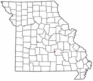
Vida is an unincorporated community in Phelps County, Missouri, United States. Vida is approximately six miles south of Rolla, near the junction of US Highway 63 and Missouri Route W. Vida is located at an elevation of 1033 feet above sea level. Vida can be found on Phelps County plat maps in Section 10, Township 36 N, Range 9 W.
Anutt is an unincorporated community in western Dent County, in the U.S. state of Missouri.
Blooming Rose is an unincorporated community in the southwest corner of Phelps County, in the U.S. state of Missouri. The community is on Missouri Route K between Beulah to the east and Duke to the north. Licking is approximately nine miles (14 km) to the southeast, in Texas County.
Craddock is an unincorporated community in southern Phelps County, in the U.S. state of Missouri. The community is one mile east of U.S. Route 63. Licking is approximately nine miles to the south in Texas County and Edgar Springs is about nine miles to the north.
De Camp is an extinct town in eastern Phelps County, in the U.S. state of Missouri. The community was located on the Elliott Branch of Norman Creek, approximately three-quarters of one mile east of Missouri Route F and about six miles south of St. James.
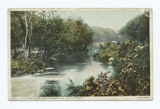
Little Piney Creek is a stream in the Phelps, Texas and Dent counties of the Ozarks of southern Missouri. It is a tributary of the Gasconade River.
Macedonia is an extinct town in northern Phelps County, in the U.S. state of Missouri.
Relfe is an extinct town in western Phelps County, in the U.S. state of Missouri. The GNIS classifies it as a populated place.
Westcott is an extinct town in northwestern Phelps County, in the U.S. state of Missouri. The community lies on Missouri Route C approximately three quarters of a mile east of Tick Creek and three miles north-northwest of Doolittle and I-44.
Winkler is an unincorporated community in southeast Phelps County, in the U.S. state of Missouri. The community is located on Missouri Route 68, thirteen miles north of Salem and eleven miles south of St. James.
Yancy Mills is an unincorporated community in Phelps County, Missouri, United States.
Mahan is an unincorporated community in Texas County, in the U.S. state of Missouri. The community was located on Missouri Route 137 and Missouri Route V, approximately one mile south of Oscar and four miles north of Raymondville. It is at an elevation of 1,309 ft (399 m). The Mahan Cemetery lies about one mile east on Route V.
Varvol is an unincorporated community in southern Texas County, in the U.S. state of Missouri. The community is on the South Prong of Jacks Fork at the intersection of Missouri Route HH and Varvel Road. The community of Sargent is approximately 3.5 miles to the west on Varvel Road and Willow Springs in adjacent Howell County is about seven miles south on route HH and Missouri Route 137. Varvel School was about three miles east along the north bank of the river.
Vessie is an extinct town in northern Phelps County, in the U.S. state of Missouri. The community is on a ridge between Kaintuck Hollow to the west and Little Piney Creek to the east at an elevation of 1060 feet. The community is at the intersection of Missouri Route T and a county road. It lies approximately four miles south of Newburg and is within the Mark Twain National Forest.
References
- ↑ U.S. Geological Survey Geographic Names Information System: Flat
- ↑ Missouri Atlas & Gazetteer, DeLorme, 1998, First edition, pp. 46 & 54, ISBN 0-89933-224-2
- ↑ "Post Offices". Jim Forte Postal History. Archived from the original on 20 December 2016. Retrieved 5 December 2016.
- ↑ "Phelps County Place Names, 1928–1945". The State Historical Society of Missouri. Archived from the original on June 24, 2016. Retrieved December 5, 2016.
37°44′43″N91°55′45″W / 37.74528°N 91.92917°W
Municipalities and communities of Phelps County, Missouri, United States | ||
|---|---|---|
| Cities |  | |
| Townships | ||
| Unincorporated communities | ||
| Ghost towns | ||
| | This Phelps County, Missouri state location article is a stub. You can help Wikipedia by expanding it. |