
Bass Strait is a strait separating the island state of Tasmania from the Australian mainland. The strait provides the most direct waterway between the Great Australian Bight and the Tasman Sea, and is also the only maritime route into the economically prominent Port Phillip Bay.

Flinders Island, the largest island in the Furneaux Group, is a 1,367-square-kilometre (528 sq mi) island in the Bass Strait, northeast of the island of Tasmania. Flinders Island was the place where the last remnants of aboriginal Tasmanian population were exiled by the colonial British government. Today Flinders Island is part of the state of Tasmania, Australia. It is 54 kilometres (34 mi) from Cape Portland and is located on 40° south, a zone known as the Roaring Forties.

The Furneaux Group is a group of approximately 100 islands located at the eastern end of Bass Strait, between Victoria and Tasmania, Australia. The islands were named after British navigator Tobias Furneaux, who sighted the eastern side of these islands after leaving Adventure Bay in 1773 on his way to New Zealand to rejoin Captain James Cook. Navigator Matthew Flinders was the first European to explore the Furneaux Islands group, in the Francis in 1798, and later that year in the Norfolk.

Melville Island is an island in the eastern Timor Sea, off the coast of the Northern Territory, Australia. Along with Bathurst Island and nine smaller uninhabited islands, it forms part of the group known as the Tiwi Islands, which are under the jurisdiction of the Northern Territory in association with the Tiwi Land Council as the regional authority.

Cape Barren Island, officially truwana / Cape Barren Island, is a 478-square-kilometre (185 sq mi) island in the Bass Strait, off the north east coast of Tasmania, Australia. It is the second largest island of the Furneaux Group; Flinders Island lies to the north, with the smaller Clarke Island to the south. The highest point on the island is Mount Munro at 715 metres (2,346 ft). Mount Munro is probably named after James Munro, a former convict and then sealer, who lived from the 1820s for more than 20 years with several women on nearby Preservation Island.

Cape Leeuwin is the most south-westerly mainland point of the Australian continent, in the state of Western Australia.

His Majesty's Armed Survey Vessel Lady Nelson was commissioned in 1799 to survey the coast of Australia. At the time large parts of the Australian coast were unmapped and Britain had claimed only part of the continent. The British Government were concerned that, in the event of settlers of another European power becoming established in Australia, any future conflict in Europe would lead to a widening of the conflict into the southern hemisphere to the detriment of the trade that Britain sought to develop. It was against this background that Lady Nelson was chosen to survey and establish sovereignty over strategic parts of the continent.
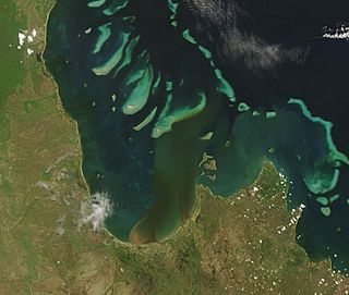
Princess Charlotte Bay is a large bay on the east coast of Far North Queensland at the base of Cape York Peninsula, 350 km north northwest of Cairns. Princess Charlotte Bay is a part of the Great Barrier Reef Marine Park and it is a habitat for the dugong.
Denham Island is part of the Great Barrier Reef Marine Park at the tip of Cape Melville, Queensland in Bathurst Bay.
Maclear Island is part of the Great Barrier Reef Marine Park at the tip of Cape Melville, Queensland in Bathurst Bay.

Stanley Island is part of the Great Barrier Reef Marine Park at the tip of Cape Melville, Queensland in Bathurst Bay. It is located North of Denham Island and Flinders Island in the Flinders Group National Park in Princess Charlotte Bay. The island is a popular tourist destination with fine anchorage between the islands and along various coastal stretches. Stanley Island was first declared a national park in 1939.
King Island is part of the Great Barrier Reef Marine Park at the tip of Cape Melville, Queensland in Bathurst Bay.
Clack Island is part of the Great Barrier Reef Marine Park at the tip of Cape Melville, Queensland in Bathurst Bay, Australia.
Blackwood Island is part of the Great Barrier Reef Marine Park at the tip of Cape Melville, Queensland in Bathurst Bay.
Port Davey is an oceanic inlet located in the south west region of Tasmania, Australia.

The Tiwi people are one of the many Aboriginal groups of Australia. Nearly 2,000 Tiwi people live on Bathurst and Melville Islands, which make up the Tiwi Islands, lying about 48 kilometres (30 mi) from Darwin. The Tiwi language is a language isolate, with no apparent link to the languages of Arnhem Land on the Australian mainland. Their society is based on matrilineal descent, and marriage plays a very important part in many aspects of their lives. Art and music form an intrinsic part of their societal and spiritual rituals. The Stolen Generations saw many Indigenous people brought to the Tiwi Islands who were not of direct Tiwi descent.

The Backstairs Passage is a strait in South Australia lying between Fleurieu Peninsula on the Australian mainland and Dudley Peninsula on the eastern end of Kangaroo Island. The western edge of the passage is a line from Cape Jervis on Fleurieu Peninsula to Kangaroo Head on Kangaroo Island. The Pages, a group of islets, lie in the eastern entrance to the strait. About 14 km wide at its narrowest, it was formed by the rising sea around 13,000 years ago, at the end of the Pleistocene era, when it submerged the land connecting what is now Kangaroo Island with the Fleurieu Peninsula. Backstairs Passage was named by Matthew Flinders whilst he and his crew on HMS Investigator were exploring and mapping the coastline of South Australia in 1802.
The Marrett River language, also known as Urratjingu, is an extinct Australian language of the Queensland coast. It remains unclassified, but is known to have been quite distinct from Flinders Island language to the east and from the various languages spoken by the Lama-Lama to its west.
The Mutumui were an indigenous Australian people of northern Queensland.
The Walmbaria are an indigenous Australian people of Cape York Peninsula in northern Queensland.
