Maniago is a town and comune (municipality) in the Regional decentralization entity of Pordenone, in the Friuli subregion of Friuli-Venezia Giulia, north-eastern Italy. It is known principally today for production of steel blades used by producers of knives, scissors, and shears, exported worldwide.
Basiliano is a comune (municipality) in the Regional decentralization entity of Udine in the Italian region of Friuli-Venezia Giulia, located about 70 kilometres (43 mi) northwest of Trieste and about 12 kilometres (7 mi) southwest of Udine.
Corno di Rosazzo is a comune (municipality) in the Regional decentralization entity of Udine in the Italian region of Friuli-Venezia Giulia, located about 45 kilometres (28 mi) northwest of Trieste and about 20 kilometres (12 mi) southeast of Udine. As of 31 December 2004, it had a population of 3,313 and an area of 12.5 square kilometres (4.8 sq mi).
Rive d'Arcano is a comune (municipality) in the Regional decentralization entity of Udine in the Italian region of Friuli-Venezia Giulia, located about 80 kilometres (50 mi) northwest of Trieste and about 15 kilometres (9 mi) northwest of Udine. As of 31 December 2004, it had a population of 2,363 and an area of 22.5 square kilometres (8.7 sq mi).

Sauris is a comune (municipality) in the Regional decentralization entity of Udine in the Italian region of Friuli-Venezia Giulia. At an elevation of 1,212 m (3,976 ft), it is the second highest municipality in the region and one of the German language islands in Northeast Italy. Sauris is part of the Alpine pearls cooperation for sustainable tourism.
Terzo d'Aquileia is a comune (municipality) in the Regional decentralization entity of Udine in the Italian region of Friuli-Venezia Giulia, located about 40 kilometres (25 mi) northwest of Trieste and about 30 kilometres (19 mi) south of Udine.
Trivignano Udinese is a comune (municipality) in the Regional decentralization entity of Udine in the Italian region of Friuli-Venezia Giulia, located about 50 kilometres (31 mi) northwest of Trieste and about 15 kilometres (9 mi) southeast of Udine. Its frazione (borough) of Clauiano is one of I Borghi più belli d'Italia.

Forgaria nel Friuli is a comune (municipality) in the Regional decentralization entity of Udine, in the Italian region of Friuli-Venezia Giulia, located about 90 kilometres (56 mi) northwest of Trieste and about 25 kilometres (16 mi) northwest of Udine. As of 31 December 2004, it had a population of 1,944 and an area of 29.2 square kilometres (11.3 sq mi).
Brugnera is a comune (municipality) in the Regional decentralization entity of Pordenone, in the Italian region of Friuli-Venezia Giulia, located about 100 kilometres (62 mi) northwest of Trieste and about 12 kilometres (7 mi) southwest of Pordenone, with about 9,000 inhabitants.
Budoia is a comune (municipality) in the Regional decentralization entity of Pordenone at the foot of the Dolomites mountain range in the Italian region of Friuli-Venezia Giulia, located about 110 kilometres (68 mi) northwest of Trieste and about 13 kilometres (8 mi) northwest of Pordenone. As of 31 December 2004, it had a population of 2,311 and an area of 37.7 square kilometres (14.6 sq mi).
Caneva is a comune (municipality) in the Regional decentralization entity of Pordenone in the Italian region of Friuli-Venezia Giulia, located about 110 kilometres (68 mi) northwest of Trieste and about 15 kilometres (9 mi) west of Pordenone. As of 31 December 2004, it had a population of 6,374 and an area of 42.0 square kilometres (16.2 sq mi).
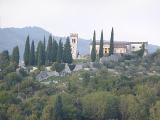
Castelnovo del Friuli is a comune (municipality) in the Regional decentralization entity of Pordenone, in the Italian region of Friuli-Venezia Giulia, located about 90 kilometres (56 mi) northwest of Trieste and about 30 kilometres (19 mi) northeast of Pordenone.

Clauzetto is a comune (municipality) in the Regional decentralization entity of Pordenone, in the Italian region of Friuli-Venezia Giulia, located about 100 kilometres (62 mi) northwest of Trieste and about 35 kilometres (22 mi) northeast of Pordenone.

Cordovado is a comune (municipality) in the Regional decentralization entity of Pordenone in the Italian region of Friuli-Venezia Giulia, located about 80 kilometres (50 mi) northwest of Trieste and about 20 kilometres (12 mi) southeast of Pordenone.

Pinzano al Tagliamento is a comune (municipality) in the Regional decentralization entity of Pordenone, in the Italian region of Friuli-Venezia Giulia, located about 90 kilometres (56 mi) northwest of Trieste and about 35 kilometres (22 mi) northeast of Pordenone.
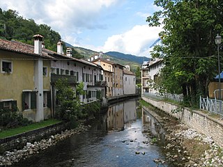
Polcenigo is a comune (municipality) in the Regional decentralization entity of Pordenone in the Italian region Friuli-Venezia Giulia, located about 110 kilometres northwest of Trieste, 95 kilometres (59 mi) north of Venice and about 14 kilometres (9 mi) northwest of Pordenone.
Roveredo in Piano is a comune (municipality) in the Regional decentralization entity of Pordenone in the Italian region of Friuli-Venezia Giulia, located about 100 kilometres northwest of Trieste and about 6 km (4 mi) northwest of Pordenone.

Sesto al Reghena is a comune (municipality) in the Regional decentralization entity of Pordenone, in the Italian region of Friuli-Venezia Giulia, located in the lower Friulian-Venetian plain about 80 kilometres (50 mi) northwest of Trieste and about 20 kilometres (12 mi) southeast of Pordenone.
Travesio is a comune (municipality) in the Regional decentralization entity of Pordenone, in the Italian region of Friuli-Venezia Giulia, located about 100 kilometres (62 mi) northwest of Trieste and about 30 kilometres (19 mi) northeast of Pordenone. As of 31 December 2004, it had a population of 1,816 and an area of 28.8 square kilometres (11.1 sq mi).

Rivignano Teor is a comune (municipality) in the Regional decentralization entity of Udine in the Italian region of Friuli-Venezia Giulia. It was established on 1 January 2014 by the merger of the municipalities of Rivignano and Teor.