
Menard County is a county located on the Edwards Plateau in the U.S. state of Texas. As of the 2020 census, its population was 1,962. The county seat is Menard. The county was created in 1858 and later organized in 1871. It is named for Michel Branamour Menard, the founder of Galveston, Texas.

McCulloch County is a county located on the Edwards Plateau in the U.S. state of Texas. At the 2020 census, its population was 7,630. Its county seat is Brady. The county was created in 1856 and later organized in 1876. It is named for Benjamin McCulloch, a famous Texas Ranger and Confederate general.
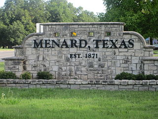
Menard is a city in and the county seat of Menard County, Texas, United States. Its population was 1,471 at the 2010 census.

The Fort McKavett State Historic Site is a former United States Army installation located in Menard County, Texas. The fort was first established in 1852 as part of a line of forts in Texas intended to protect migrants traveling to California. The fort was deemed unnecessary and abandoned in 1859 and was occupied by settlers. From 1861 to 1863, during the American Civil War, the fort became an outpost of Confederate forces on the Texas frontier until they left for other theaters of the war. When the US Army returned to Texas in the later 1860s, the fort was reoccupied and rebuilt, and became a base for the "Buffalo Soldier", or all-African American, 24th Infantry and 9th Cavalry Regiments.
Pontotoc is an unincorporated community on Pontotoc Creek, in northeastern Mason County, Texas, United States. The community is located at the junction of State Highway 71 and Ranch to Market Road 501.

Peoa is an unincorporated census-designated place in southwestern Summit County, Utah, United States, between Jordanelle and Rockport State Parks. It lies along State Route 32, south of the city of Coalville, the county seat of Summit County. Its elevation is 6,191 feet (1,887 m). The population was 253 at the 2010 census. Peoa is unincorporated with the ZIP code of 84061.

Sevier is an unincorporated community in southwestern Sevier County, Utah, United States. It lies in the valley of the Sevier River along U.S. Route 89 southwest of the city of Richfield, the county seat of Sevier County. Its elevation is 5,584 feet (1,702 m).

Sand Springs is an unincorporated rural hamlet in southwestern Garfield County, Montana, United States. It lies along the northern side of Highway 200, southwest of the town of Jordan, the county seat of Garfield County. Its elevation is 3,192 feet (973 m).
Otter is an unincorporated community in southwestern Powder River County, Montana, United States, in the Custer National Forest. It lies along local roads southwest of the town of Broadus, the county seat of Powder River County. Its elevation is 3,484 feet (1,062 m). Although Otter is unincorporated, it has a post office, with the ZIP code of 59062.
Powderville, also Elkhorn Crossing is an unincorporated community in northeastern Powder River County, Montana, United States, along the Powder River. It is a small cluster of buildings that lies along local roads northeast of the town of Broadus, the county seat of Powder River County. Its elevation is 2,828 feet (862 m).
Knott is an unincorporated community in northwestern Howard County, Texas, United States. It lies along FM 846 northwest of the city of Big Spring, the county seat of Howard County. Its elevation is 2,612 feet (796 m). Although Knott is unincorporated, it has a post office, with the ZIP code of 79748.
Knickerbocker is an unincorporated community in southwestern Tom Green County, Texas, United States. It lies along Farm to Market Road 2335 southwest of the city of San Angelo, the county seat of Tom Green County. Its elevation is 2,051 feet (625 m). Although Knickerbocker is unincorporated, it has a post office, with the ZIP code of 76939.

Toyahvale is an unincorporated community in southern Reeves County, Texas, United States. It lies along State Highway 17 and FM 3078 south of the city of Pecos, the county seat of Reeves County. Despite its similar name, Toyahvale is distinct from the town of Toyah, which lies 25 miles (40 km) to the north. Its elevation is 3,323 feet (1,013 m). Although Toyahvale is unincorporated, it has a post office, with the ZIP code of 79786.
Summerfield is an unincorporated community in northwestern Castro County, Texas, United States. It lies along U.S. Route 60 northwest of the city of Dimmitt, the county seat of Castro County. Its elevation is 3,937 feet (1,200 m). Although Summerfield is unincorporated, it has a post office, with the ZIP code of 79085.
Vancourt is an unincorporated community in eastern Tom Green County, Texas, United States. It lies along U.S. Route 87 east of the city of San Angelo, the county seat of Tom Green County. Its elevation is 1,867 feet (569 m). Although Vancourt is unincorporated, it has a post office, with the ZIP code of 76955; the ZCTA for ZIP Code 76955 had a population of 108 at the 2000 census.
Dodge is an unincorporated community in eastern Walker County, Texas, United States, on the northern edge of the Sam Houston National Forest. It lies along FM 405 east of the city of Huntsville, the county seat of Walker County. Its elevation is 400 feet (122 m). Although Dodge is unincorporated, it has a post office, with the ZIP code of 77334; the ZCTA for ZIP Code 77334 had a population of 184 at the 2000 census.

Waring is an unincorporated community in northwestern Kendall County, Texas, United States. It lies along local roads and the Guadalupe River, northwest of the city of Boerne, the county seat of Kendall County. Its elevation is 1,345 feet (410 m). Although Waring is unincorporated, it has a post office, with the ZIP code of 78074; the ZCTA for ZIP Code 78074 had a population of 59 at the 2000 census. The community is part of the San Antonio Metropolitan Statistical Area.

Kendalia is an unincorporated community in northeastern Kendall County, Texas, United States. It is part of the Texas-German belt.
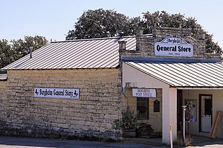
Bergheim is an unincorporated community in eastern Kendall County, Texas, United States known for its German-Texan culture and heritage. It lies along State Highway 46 east of the city of Boerne, the county seat of Kendall County. Its elevation is 1,437 feet (438 m). Although Bergheim is unincorporated, it has a post office, with the ZIP code of 78004; the ZCTA for ZIP Code 78004, consisting mostly of rural land, had a population of 1,183 at the 2010 census. The community is part of the San Antonio metropolitan statistical area. Bergheim is still a predominantly a ranching and agricultural community.
Farnsworth is a Census Designated Place in western Ochiltree County, Texas, United States. It lies at the intersection of State Highway 15 with FM376, southwest of the city of Perryton, the county seat of Ochiltree County. Its elevation is 2,995 feet (913 m). Although Farnsworth is unincorporated, it has a post office, with the ZIP code of 79033; the ZCTA for ZIP code 79033 had a population of 106 at the 2000 census.


