
Defiance is a city in and the county seat of Defiance County, Ohio, about 55 miles (89 km) southwest of Toledo and 47 miles (76 km) northeast of Fort Wayne, Indiana, in Ohio's northwestern corner. The population was 16,494 at the 2010 census.

The Maumee River is a river running in the United States Midwest from northeastern Indiana into northwestern Ohio and Lake Erie. It is formed at the confluence of the St. Joseph and St. Marys rivers, where Fort Wayne, Indiana, has developed, and meanders northeastwardly for 137 miles (220 km) through an agricultural region of glacial moraines before flowing into the Maumee Bay of Lake Erie. The city of Toledo is located at the mouth of the Maumee. The Maumee was designated an Ohio State Scenic River on July 18, 1974. The Maumee watershed is Ohio’s breadbasket; it is two-thirds farmland, mostly corn and soybeans. It is the largest watershed of any of the rivers feeding the Great Lakes, and supplies five percent of Lake Erie’s water.

The Wabash River is a 503-mile-long (810 km) river that drains most of the state of Indiana in the United States. It flows from the headwaters in Ohio, near the Indiana border, then southwest across northern Indiana turning south near the Illinois border where the southern portion forms the Indiana-Illinois border before flowing into the Ohio River. It is the largest northern tributary of the Ohio River and third largest overall, right behind the Cumberland and Tennessee Rivers. From the dam near Huntington, Indiana, to its terminus at the Ohio River, the Wabash flows freely for 411 miles (661 km). Its watershed drains most of Indiana. The Tippecanoe River, White River, Embarras River and Little Wabash River are major tributaries. The river's name comes from a Miami Indian word meaning "water over white stones".

The Wabash and Erie Canal was a shipping canal that linked the Great Lakes to the Ohio River via an artificial waterway. The canal provided traders with access from the Great Lakes all the way to the Gulf of Mexico. Over 460 miles long, it was the longest canal ever built in North America.

The Watersheds of Indiana consist of six distinct Indiana watershed regions that drain into five major bodies of water.

The Great Black Swamp was a glacially fed wetland in northwest Ohio, sections of lower Michigan, and extreme northeast Indiana, United States, that existed from the end of the Wisconsin glaciation until the late 19th century. Comprising extensive swamps and marshes, with some higher, drier ground interspersed, it occupied what was formerly the southwestern part of proglacial Lake Maumee, a holocene precursor to Lake Erie. The area was about 25 miles (40 km) wide and 100 miles (160 km) long, covering an estimated 1,500 square miles (4,000 km2). Gradually drained and settled in the second half of the 19th century, it is now highly productive farmland. However, this development has been detrimental to the ecosystem as a result of agricultural runoff. This runoff, in turn, has contributed to frequent toxic algal blooms in Lake Erie.

The Auglaize River is a 113-mile-long (182 km) tributary of the Maumee River in northwestern Ohio in the United States. It drains a primarily rural farming area in the watershed of Lake Erie. The name of the river was derived from the French term for it. The French called it "rivière à la Grande Glaize", referring to the soil in the area.

The St. Marys River is a 99-mile-long (159 km) tributary of the Maumee River in northwestern Ohio and northeastern Indiana in the United States. Prior to development, it was part of the Great Black Swamp. Today, it drains a primarily rural farming region in the watershed of Lake Erie.
The St. Joseph River is an 86.1-mile-long (138.6 km) tributary of the Maumee River in northwestern Ohio and northeastern Indiana in the United States, with headwater tributaries rising in southern Michigan. It drains a primarily rural farming region in the watershed of Lake Erie.
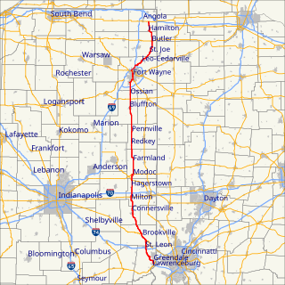
State Road 1 (SR 1) is a north–south state highway in eastern Indiana, consisting of two segments. Its southern segment begins at U.S. Highway 50 and Interstate 275 in east-central Dearborn County, just east of Lawrenceburg, and ends at Interstate 469 south of Fort Wayne. Its northern segment begins at Interstate 69 on Fort Wayne's north side, and ends at U.S. Route 20 in east-central Steuben County, approximately 6 miles (9.7 km) east of Angola.

The Treaty of Fort Meigs, also called the Treaty of the Maumee Rapids, formally titled, "Treaty with the Wyandots, etc., 1817", was the most significant Indian treaty in Ohio since the Treaty of Greenville in 1795, and resulted in cession by the Indians of nearly all remaining Indian lands in northwestern Ohio. It was the last but one and largest wholesale purchase of Indian land in Ohio.
The Maumee Torrent, also known as the Maumee Megaflood, was a catastrophic draining of Lake Maumee, the ancestor of present-day Lake Erie, that occurred approximately 14,000 to 17,000 years ago during the late Wisconsin glaciation. It happened when the waters of Lake Maumee, possibly in response to an advance of the ice front at the eastern end of the lake, overtopped a "sag" or low spot in the Fort Wayne Moraine, which was a deposit of glacial debris that acted as a natural dam at the site of present-day Fort Wayne, Indiana. This unleashed a massive flow of water that scoured a one- to two-mile-wide outlet running southwest to the Wabash River known as the "Wabash-Erie Channel", which probably followed the course of earlier, less massive drainage. The channel, now a small stream called the Little River, is the largest topographical feature in Allen County, Indiana. As much as 30 feet of fine sand, silt and organic sediments were deposited in the channel before drainage reversed and was captured by the present-day Maumee River. U.S. Route 24 between Fort Wayne and Huntington follows the channel.

Lake Maumee was a proglacial lake and an ancestor of present-day Lake Erie. It formed about 14,000 Years Before Present (YBP) as the Huron-Erie Lobe of the Laurentide Ice Sheet retreated at the end of the Wisconsin glaciation. As water levels continued to rise the lake evolved into Lake Arkona and then Lake Whittlesey.

The geography of Indiana comprises the physical features of the land and relative location of U.S. State of Indiana. Indiana is in the north-central United States and borders on Lake Michigan. Surrounding states are Michigan to the north and northeast, Illinois to the west, Kentucky to the south, and Ohio to the east. The entire southern boundary is the Ohio River.

The Kankakee Outwash Plain is a flat plain interspersed with sand dunes in the Kankakee River valley in northwestern Indiana and northeastern Illinois of the United States. It is just south of the Valparaiso Moraine and was formed during the Wisconsin Glaciation. As the glacier, stopped at the Valparaiso Moraine, melted, the meltwater was carried away to the outwash plain. On the south side of the moraine, where the elevation drops, the meltwaters eroded away valleys, carrying sand and mud with them. As the muddy meltwater reached the valley where the slope lessened, the water slowed, depositing the sand on the outwash plain. This created a smooth, flat, and sandy plain. Before its draining, the Kankakee Marsh, located on the outwash plain, was one of the largest freshwater marshes in the United States.
The Mississinawa Moraine begins in Ohio east of Lima in Hardin County, then running in a shallow arc to the south of Grand Lake St. Marys and St. Marys in Mercer County towards Fort Recovery, Ohio. Just west of Fort Recovery, the moraine again arches southward towards the Mississinewa River. The moraine follows the eastern bank of the river northwestward to where it enters the Wabash River at Wabash, Indiana. Angling towards the north and a little east, the Mississinawa moraine merges with the Packerton Moraine north of the Eel River in Whitley County near Columbia City. The moraine does not end here, but continues in a northeasterly direction through the three corners area of Michigan, Indiana, and Ohio until reaching Ann Arbor, Michigan where numerous moraines intermingle. Note: There are two common spellings of the name. Mississinawa is commonly used in the older reports. Mississinewa is the modern usage and the spelling used on modern maps and projects associated with the river. Both spellings are used interchangeably in this article, based on the source material.

Lake Kankakee formed 14,000 years before present (YBP) in the valley of the Kankakee River. It developed from the outwash of the Michigan Lobe, Saginaw Lobe, and the Huron-Erie Lobe of the Wisconsin glaciation. These three ice sheets formed a basin across Northwestern Indiana. It was a time when the glaciers were receding, but had stopped for a thousand years in these locations. The lake drained about 13,000 YBP, until reaching the level of the Momence Ledge. The outcropping of limestone created an artificial base level, holding water throughout the upper basin, creating the Grand Kankakee Marsh.

The Marseilles moraine is a terminal moraine that encircles the southern tip of Lake Michigan in North America. It begins near Elgin, Illinois, and extends south and west of Chicago metropolitan area, turning eastward 30 miles (48 km) to 40 miles (64 km) south of the lake in Kankakee and Iroqouis counties, entering Indiana. It formed during the Wisconsin glaciation. The glacier had been in retreat when it stopped for an extended period, depositing glacial till and sand creating the hills of the moraine.
The Packerton Moraine in north-central Indiana has been considered by most persons who have studied it to be a large interlobate moraine between the Saginaw and the Erie lobes. The northeast-southwest direction of the eskers north of Disko, Wabash County, and the southeast-northwest trend south of there indicated that the part of the Packerton moraine south of Disko was built by the Erie lobe and the part north of Disko by the Saginaw lobe. An esker, Miami County shows a northeast-southwest alignment, providing evidence that Packerton moraine in Miami County was built by the Erie lobe. A small area in the northwestern was deposited by the Saginaw lobe. It is named the Packerton moraine from the village of Packerton in Kosciusko County. Thirteen kames and eskers complexes are mixed with sand and gravel. The till is, sandier, especially in the part deposited by the Saginaw lobe, than in the lobe passed over some source of sand, whereas the Erie lobe did not. Water-laid or wind-blown sands are found throughout the moraine. The bulk of the sand seems to have been water-deposited, but locally the sand appears to have been reworked by the wind. Few of the sand deposits exhibit dunal forms.

Lake Wayne formed in the Lake Erie and Lake St. Clair basins around 12,500 years before present (YBP) when Lake Arkona dropped in elevation. About 20 feet (6.1 m) below the Lake Warren beaches it was early described as a lower Lake Warren level. Based on work in Wayne County, near the village of Wayne evidence was found that Lake Wayne succeeded Lake Whittlesey and preceded Lake Warren. From the Saginaw Basin the lake did not discharge water through Grand River but eastward along the edge of the ice sheet to Syracuse, New York, thence into the Mohawk valley. This shift in outlets warranted a separate from Lake Warren. The Wayne beach lies but a short distance inside the limits of the Warren beach. Its character is not greatly different when taken throughout its length in Michigan, Ohio, Pennsylvania and New York. At the type locality in Wayne County, Michigan, it is a sandy ridge, but farther north, and to the east through Ohio it is gravel. The results of the isostatic rebound area similar to the Lake Warren beaches.
