Hicksville, Ohio

Last updated

Hicksville, Ohio
St. Paul's Episcopal Church in Hicksville, angle.jpg
St. Paul's Episcopal Church, a historic site in the village
Motto(s): 
"A Proud Past, A Bright Future"
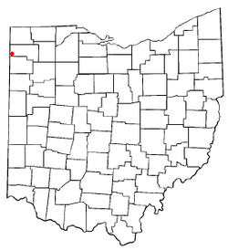
OHMap-doton-Hicksville.png
Location of Hicksville, Ohio
Map of Defiance County Ohio Highlighting Hicksville Village.png
Location of Hicksville in Defiance County
Coordinates: 41°17′45″N84°45′33″W / 41.29583°N 84.75917°W / 41.29583; -84.75917
Country United States
State Ohio
County Defiance
Area
[1]
  Total2.55 sq mi (6.61 km2)
  Land2.55 sq mi (6.61 km2)
  Water0.00 sq mi (0.00 km2)
Elevation
[2]
764 ft (233 m)
Population
 (2020)
  Total3,431
  Estimate 
(2023) [3]
3,422
  Density1,343.38/sq mi (518.77/km2)
Time zone UTC-5 (Eastern (EST))
  Summer (DST) UTC-4 (EDT)
ZIP code
43526
Area code 419
FIPS code 39-35098 [4]
GNIS feature ID2398500 [2]
Website http://www.villageofhicksville.com/

Hicksville is a village in Defiance County, Ohio, United States. The population was 3,431 at the 2020 census. It sits approximately 2.2 miles east of the Ohio-Indiana border.

Contents

History

Led by Henry W. Hicks, the Hicks Land Company platted the community in 1835 and 1836. [5] A post office has been in operation at Hicksville since 1838. [6] Hicksville was incorporated as a village in 1871. [5] Hicksville made its debut in American literature in 1885 when Mark Twain mentioned the town in chapter 33 of Adventures of Huckleberry Finn . Tom Sawyer claims to be a stranger from Hicksville, Ohio. [7]

Geography

According to the United States Census Bureau, the village has a total area of 2.66 square miles (6.89 km2), all land. [8]

Demographics

Historical population
CensusPop.Note
1880 1,212
1890 2,14176.7%
1900 2,52017.7%
1910 2,395−5.0%
1920 2,378−0.7%
1930 2,4452.8%
1940 2,5494.3%
1950 2,6293.1%
1960 3,11618.5%
1970 3,46111.1%
1980 3,92913.5%
1990 3,664−6.7%
2000 3,649−0.4%
2010 3,581−1.9%
2020 3,431−4.2%
2023 (est.)3,422 [3] −0.3%
U.S. Decennial Census [9]

2010 census

As of the census [10] of 2010, there were 3,581 people, 1,432 households, and 946 families living in the village. The population density was 1,346.2 inhabitants per square mile (519.8/km2). There were 1,571 housing units at an average density of 590.6 per square mile (228.0/km2). The racial makeup of the village was 94.9% White, 0.3% African American, 0.3% Native American, 0.4% Asian, 2.1% from other races, and 2.0% from two or more races. Hispanic or Latino of any race were 5.1% of the population.

There were 1,432 households, of which 34.1% had children under the age of 18 living with them, 45.7% were married couples living together, 14.6% had a female householder with no husband present, 5.7% had a male householder with no wife present, and 33.9% were non-families. 29.8% of all households were made up of individuals, and 12.2% had someone living alone who was 65 years of age or older. The average household size was 2.47 and the average family size was 3.01.

The median age in the village was 36.9 years. 26% of residents were under the age of 18; 9.2% were between the ages of 18 and 24; 24.6% were from 25 to 44; 24% were from 45 to 64; and 16% were 65 years of age or older. The gender makeup of the village was 48.1% male and 51.9% female.

2000 census

As of the census [4] of 2000, there were 3,649 people, 1,476 households, and 957 families living in the village. The population density was 1,450.4 inhabitants per square mile (560.0/km2). There were 1,567 housing units at an average density of 622.8 per square mile (240.5/km2). The racial makeup of the village was 96.88% White, 0.14% African American, 0.33% Native American, 0.08% Asian, 1.34% from other races, and 1.23% from two or more races. Hispanic or Latino of any race were 3.32% of the population.

There were 1,476 households, out of which 32.9% had children under the age of 18 living with them, 49.9% were married couples living together, 10.4% had a female householder with no husband present, and 35.1% were non-families. 29.9% of all households were made up of individuals, and 13.5% had someone living alone who was 65 years of age or older. The average household size was 2.43 and the average family size was 3.03.

In the village, the population was spread out, with 27.3% under the age of 18, 8.7% from 18 to 24, 28.3% from 25 to 44, 19.8% from 45 to 64, and 15.9% who were 65 years of age or older. The median age was 35 years. For every 100 females there were 88.8 males. For every 100 females age 18 and over, there were 88.2 males.

The median income for a household in the village was $39,459, and the median income for a family was $43,571. Males had a median income of $32,066 versus $22,413 for females. The per capita income for the village was $1,385. About 2.1% of families and 3.2% of the population were below the poverty line, including 2.7% of those under age 18 and 1.9% of those age 65 or over.

Education

The Hicksville Exempted Village School district operates one pre-K–12 school in the village. [11] Hicksville has a public library, a branch of the Defiance Public Library System. [12]

Notable people

Related Research Articles

<span class="mw-page-title-main">Defiance County, Ohio</span> County in Ohio, United States

Defiance County is a county located in the U.S. state of Ohio. As of the 2020 census, the population was 38,286. Its county seat and largest city is Defiance. The county was named after an early Army fortification, Fort Defiance, which was so named by Mad Anthony Wayne to signify the settlers' "defiance" of the Indians. The Defiance, OH Micropolitan Statistical Area includes all of Defiance County.

<span class="mw-page-title-main">Lakeshire, Missouri</span> City in Missouri, United States

Lakeshire is a city in St. Louis County, Missouri, United States. The population was 1,432 at the 2010 census.

<span class="mw-page-title-main">Defiance, Ohio</span> City in Ohio, United States

Defiance is a city in and the county seat of Defiance County, Ohio, United States, about 55 miles (89 km) southwest of Toledo and 47 miles (76 km) northeast of Fort Wayne, Indiana, in Ohio's northwestern corner. The population was 17,066 at the 2020 census.

<span class="mw-page-title-main">Ney, Ohio</span> Village in Ohio, United States

Ney is a village in Defiance County, Ohio, United States. The population was 303 at the 2020 census. Ney has been noted for having one of the shortest place names in Ohio.

<span class="mw-page-title-main">Sherwood, Defiance County, Ohio</span> Village in Ohio, United States

Sherwood is a village in Defiance County, Ohio, United States. The population was 802 at the 2020 census.

<span class="mw-page-title-main">Addyston, Ohio</span> Village in Ohio, United States

Addyston is a village in Miami Township, Hamilton County, Ohio, United States. Located along the Ohio River, it is a western suburb of the neighboring city of Cincinnati. The population was 927 at the 2020 census.

<span class="mw-page-title-main">Fruit Hill, Ohio</span> Census-designated place in Ohio, United States

Fruit Hill is a census-designated place (CDP) in Hamilton County, Ohio, United States. The population was 3,748 at the 2020 census.

<span class="mw-page-title-main">Holgate, Ohio</span> Village in Ohio, United States

Holgate is a village in Henry County, Ohio, United States. The population was 1,061 at the 2020 census.

<span class="mw-page-title-main">Greenwich, Ohio</span> Village in Ohio, United States

Greenwich is a village in Huron County, Ohio, United States. The population was 1,409 at the 2020 census. It is served by a branch of the Willard Memorial Library.

<span class="mw-page-title-main">Centerburg, Ohio</span> Village in Ohio, United States

Centerburg is a village in Knox County, Ohio, United States, along the North Fork of the Licking River. As of the 2020 census, the village population was 1,690. Centerburg is located near the geographical center of Ohio.

<span class="mw-page-title-main">Brinkhaven, Ohio</span> Village in Ohio, United States

Brinkhaven, once known as Mount Holly and Gann, is a village in Knox County, Ohio, United States. The population was 114 at the 2020 census.

<span class="mw-page-title-main">Tarlton, Ohio</span> Village in Ohio, United States

Tarlton is a village in Fairfield and Pickaway counties in the U.S. state of Ohio. The population was 254 at the 2020 census.

<span class="mw-page-title-main">Limaville, Ohio</span> Census-designated place in Ohio, United States

Limaville is a census-designated place (CDP) and former village in Stark County, Ohio, United States. The population was 151 at the 2020 census. It is part of the Canton–Massillon Metropolitan Statistical Area.

<span class="mw-page-title-main">Macksburg, Ohio</span> Village in Ohio, United States

Macksburg is a village in Washington County, Ohio, United States, along the West Fork of Duck Creek. The population was 120 at the 2020 census. The village is about 28 miles (45 km) south of Cambridge, Ohio.

<span class="mw-page-title-main">Weston, Ohio</span> Village in Ohio, United States

Weston is a village in Wood County, Ohio, United States. The population was 1,455 at the 2020 census. Weston is located just 10 miles west of Bowling Green, Ohio, a university town.

<span class="mw-page-title-main">Swatara Township, Lebanon County, Pennsylvania</span> Township in Pennsylvania, United States

Swatara Township is a township in Lebanon County, Pennsylvania, United States. It is part of the Lebanon, PA Metropolitan Statistical Area. The population was 5,045 at the 2020 census.

<span class="mw-page-title-main">Follansbee, West Virginia</span> City in West Virginia, United States

Follansbee is a city in Brooke County, West Virginia, United States, located along the Ohio River. The population was 2,853 at the 2020 census, a decrease from 2,986 at the 2010 census. It is part of the Weirton–Steubenville metropolitan area. The city was named after the Follansbee brothers, the proprietors of a local steel mill.

<span class="mw-page-title-main">New Haven, West Virginia</span> Town in West Virginia, United States

New Haven is a town in Mason County, West Virginia, United States, along the Ohio River. The population was 1,485 at the 2020 census. It is part of the Point Pleasant, WV–OH Micropolitan Statistical Area.

<span class="mw-page-title-main">Wilson, Ohio</span> Village in Ohio, United States

Wilson is a village in Belmont and Monroe counties in the U.S. state of Ohio. The population was 129 at the 2020 census. It is part of the Wheeling metropolitan area.

<span class="mw-page-title-main">Gratiot, Ohio</span> Village in Ohio, United States

Gratiot is a village in Licking and Muskingum counties in the U.S. state of Ohio. The population was 215 at the 2020 census.

References

  1. "ArcGIS REST Services Directory". United States Census Bureau. Retrieved September 20, 2022.
  2. 1 2 U.S. Geological Survey Geographic Names Information System: Hicksville, Ohio
  3. 1 2 "Annual Estimates of the Resident Population for Incorporated Places in Ohio: April 1, 2020 to July 1, 2023". United States Census Bureau. Retrieved July 9, 2024.
  4. 1 2 "U.S. Census website". United States Census Bureau . Retrieved January 31, 2008.
  5. 1 2 History of Defiance County, Ohio: Containing a History of the County; Its Townships, Towns, Etc.; Military Record; Portraits of Early Settlers and Prominent Men; Farm Views; Personal Reminiscences, Etc. Warner, Beers. 1883. pp. 280–281.
  6. "Defiance County". Jim Forte Postal History. Retrieved December 21, 2015.
  7. "HUCKLEBERRY FINN, By Mark Twain, Complete". goo.gl. Retrieved September 22, 2018.
  8. "US Gazetteer files 2010". United States Census Bureau. Archived from the original on January 25, 2012. Retrieved January 6, 2013.
  9. "Census of Population and Housing". Census.gov. Retrieved June 4, 2015.
  10. "U.S. Census website". United States Census Bureau . Retrieved January 6, 2013.
  11. "District profile". Hicksville Exempted Village School district. Retrieved February 25, 2018.
  12. "Locations". Defiance Public Library System. Archived from the original on February 25, 2018. Retrieved February 25, 2018.