Fortress of Ghat

Last updated
Fortress of Ghat
Ghat, Libya
Fortress medina ghat.jpeg
Fortress of Ghat
Coordinates 24°58′01″N10°10′50″E / 24.96702°N 10.18051°E / 24.96702; 10.18051 Coordinates: 24°58′01″N10°10′50″E / 24.96702°N 10.18051°E / 24.96702; 10.18051
Type Fort
Site information
Open to
the public
Yes

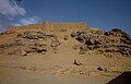
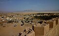
The Fortress of Ghat is a fort on top of the hill of Koukemen in Ghat, Libya. It was started by the Military of the Ottoman Empire and rebuilt in 1930s after partial destruction caused by the Italian campaign against Libya. [1]

Contents

Summary

The Fortress was built by the Ottoman Turks’ Empire during their rule of Tripoli and Fezzan, and it destroyed by the Italian colonialists who occupied the city in 1913. It is not excluded that the French also used it during their occupation of Fezzan (1943-1952) after defeating the Italians in the last years of the Second World War. It has been rebuilt and is now a distinctive tourist attraction in the city. [2] [3]

Location

The road to the top of the fortress definitely passes through the paths of the ancient city of Ghat, ‘Agram’, standing at the top of Ghat Fortress can easily get a bird's-eye view of the city and the nearby palm plantations, as well as the Acacus Mountains, with their charming rock carvings, and golden sand dunes, whereas under the fortress’ western wall there is an underground tunnel that might have been used in emergency situations, such as sieges. [4] [5]

Related Research Articles

Tripoli Capital and chief port of Libya

Tripoli is the capital and largest city of Libya, with a population of about three million people in 2019. It is located in the northwest of Libya on the edge of the desert, on a point of rocky land projecting into the Mediterranean Sea and forming a bay. It includes the port of Tripoli and the country's largest commercial and manufacturing center. It is also the site of the University of Tripoli. The vast Bab al-Azizia barracks, which includes the former family estate of Muammar Gaddafi, is also located in the city. Colonel Gaddafi largely ruled the country from his residence in this barracks.

Cyrenaica Eastern coastal region of Libya

Cyrenaica is the eastern coastal region of Libya. Also known as Pentapolis in antiquity, it formed part of the Roman province of Crete and Cyrenaica, later divided into Libya Pentapolis and Libya Sicca. During the Islamic period, the area came to be known as Barqa, after the city of Barca.

Awjila Town in Cyrenaica, Libya

Awjila is an oasis town in the Al Wahat District in the Cyrenaica region of northeastern Libya. Since classical times it has been known as a place where high quality dates are farmed. From the Arab conquest in the 7th century, Islam has played an important role in the community. The oasis is located on the east-west caravan route between Egypt and Tripoli, and on the north-south route between Benghazi and the Sahel between Lake Chad and Darfur, and in the past was an important trading center. It is the place after which the Awjila language, an Eastern Berber language, is named. The people cultivate small gardens using water from deep wells. Recently, the oil industry has become an increasingly important source of employment.

Misrata City in Tripolitania, Libya

Misrata is a city in the Misrata District in northwestern Libya, situated 187 km (116 mi) to the east of Tripoli and 825 km (513 mi) west of Benghazi on the Mediterranean coast near Cape Misrata. With a population of about 881,000, it is the third-largest city in Libya, after Tripoli and Benghazi. It is the capital city of the Misrata District and has been called the trade capital of Libya. The harbor is at Qasr Ahmad.

Fezzan Region in Libya

Fezzan is the southwestern region of modern Libya. It is largely desert, but broken by mountains, uplands, and dry river valleys (wadis) in the north, where oases enable ancient towns and villages to survive deep in the otherwise inhospitable Sahara Desert. The term originally applied to the land beyond the coastal strip of Africa proconsularis, including the Nafusa and extending west of modern Libya over Ouargla and Illizi. As these Berber areas came to be associated with the regions of Tripoli, Cirta or Algiers, the name was increasingly applied to the arid areas south of Tripolitania.

Tripolitania Historic region of Libya

Tripolitania is a historic region and former province of Libya.

Ghat, Libya Town in Fezzan, Libya

Ghat is the capital of the Ghat District in the Fezzan region of southwestern Libya, located just east of the Algerian border.

Murzuk Town in Fezzan, Libya

Murzuk, Murzuq, Murzug or Merzug is an oasis town and the capital of the Murzuq District in the Fezzan region of southwest Libya. It lies on the northern edge of the Murzuq Desert, an extremely arid region of ergs or great sand dunes which is part of the greater Sahara Desert.

Ghadames Town in Tripolitania, Libya

Ghadames or Ghadamis is an oasis Berber town in the Nalut District of the Tripolitania region in northwestern Libya.

Provinces of Libya Traditional administrative divisions of Libya

The Provinces of Libya were prescribed in 1934, during the last period of colonial Italian Libya, and continued through post-independence Libya until 1963 when the Governorates system was instituted.

Ottoman Tripolitania Administrative division of the Ottoman Empire in present-day Libya (1551-1912)

The coastal region of what is today Libya was ruled by the Ottoman Empire from 1551 to 1912, first, from 1551 to 1864, as the Eyalet of Tripolitania or Bey and Subjects of Tripoli of Barbary, later, from 1864 to 1912, as the Vilayet of Tripolitania. It was also known as the Kingdom of Tripoli, even though it was not technically a kingdom, but an Ottoman province ruled by pashas (governors). The Karamanli dynasty ruled the province as a de facto hereditary monarchy from 1711 to 1835, despite remaining under nominal Ottoman rule and suzerainty from Constantinople.

Italian colonization of Libya Aspect of history

The Italian colonizationof Libya began in 1911 and it lasted until 1943. The country, which was previously an Ottoman possession, was occupied by Italy in 1911 after the Italo-Turkish War, which resulted in the establishment of two colonies: Italian Tripolitania and Italian Cyrenaica. In 1934, the two colonies were merged into one colony which was named the colony of Italian Libya. In 1937, this colony was divided into four provinces, and in 1939, the coastal provinces became a part of metropolitan Italy. The colonization lasted until Libya's occupation by Allied forces in 1943, but it was not until the 1947 Paris Peace Treaty that Italy officially renounced all of its claims to Libya's territory.

Postage stamps and postal history of Tripolitania

This is a survey of the postage stamps and postal history of Tripolitania, now part of Libya.

Tourism in Libya

Tourism in Libya is an industry heavily hit by the Libyan Civil War. Before the war tourism was developing, with 149,000 tourists visiting Libya in 2004, rising to 180,000 in 2007, although this still only contributed less than 1% of the country's GDP. There were 1,000,000 day visitors in the same year. The country is best known for its ancient Greek and Roman ruins and Sahara desert landscapes.

Al-Khums Place in Tripolitania, Libya

Al-Khums or Khoms is a city, port and the de jure capital of the Murqub District on the Mediterranean coast of Libya with an estimated population of around 202,000. The population at the 1984 census was 38,174. Between 1983 and 1995 it was the administrative center of al-Khums District.

Gharyan City in Tripolitania, Libya

Gharyan is a city in northwestern Libya, in Jabal al Gharbi District, located 80 km south of Tripoli. Prior to 2007, it was the administrative seat of Gharyan District. Gharyan is one of the largest towns in the Western Mountains.

Italian Spahis were light cavalry colonial troops of the Kingdom of Italy, raised in Italian Libya between 1912 and 1942.

Allied administration of Libya

The Allied administration of Libya was the control of the ex-Italian colony of Italian Libya by the Allies from 13 May 1943 until Libyan independence was granted in 1951. It was divided into two parts:

Postage stamps of Italian Libya

Postage stamps of Italian Libya were stamps issued by the Kingdom of Italy for use in Italian Libya, between 1912 and 1943.

The following is a timeline of the history of the city of Benghazi, Libya.

References

  1. Andrew McGregor (May 2016). "The Strategic Topography of Southern Libya". Aberfoylesecurity.com. Retrieved 19 September 2017.
  2. "Ghat | Libya Adventures". 2021-01-01. Retrieved 2021-09-03.
  3. "Ghat". famouswonders.com. 2010-05-12. Retrieved 2021-09-03.
  4. "Ghat, the city of heritage and beauty | The Libya Observer". www.libyaobserver.ly. Retrieved 2021-09-03.
  5. Passon, Jacqueline; Braun, Klaus; Hamid, Said; al-Mahdi Khalifa, Salih; as-Sadeq at-Tellisi, Najmiya; El Nayedh, Mansour; Metzger, Joschua (2020), Braun, Klaus; Passon, Jacqueline (eds.), "Places of Trade, Communication and Religion—Important Oases", Across the Sahara: Tracks, Trade and Cross-Cultural Exchange in Libya, Cham: Springer International Publishing, pp. 165–247, doi: 10.1007/978-3-030-00145-2_6 , ISBN   978-3-030-00145-2 , retrieved 2021-09-03