
The Humboldt–Toiyabe National Forest (HTNF) is the principal U.S. National Forest in the U.S. state of Nevada, and has a smaller portion in Eastern California. With an area of 6,289,821 acres (25,454.00 km2), it is the largest U.S. National Forest outside Alaska.
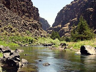
The Bruneau River is a 153-mile-long (246 km) tributary of the Snake River, in the U.S. states of Idaho and Nevada. It runs through a narrow canyon cut into ancient lava flows in southwestern Idaho. The Bruneau Canyon, which is up to 1,200 feet (370 m) deep and 40 miles (64 km) long, features rapids and hot springs, making it a popular whitewater trip.

Jarbidge is an unincorporated community in Elko County, Nevada, United States. Located at the bottom of the Jarbidge River's canyon near the north end of the Jarbidge Mountains, it lies within the Jarbidge Ranger District of the Humboldt-Toiyabe National Forest and is near the northwest edge of the Jarbidge Wilderness, approximately 10 miles (16 km) south of the Idaho–Nevada border. The ZIP code for Jarbidge is 89826.

The Jarbidge Wilderness is a wilderness area located in the Jarbidge Mountains of northern Elko County in northeastern Nevada, United States. It is contained within the Jarbidge Ranger District of the Humboldt-Toiyabe National Forest.

The Jarbidge River is a 51.8-mile-long (83.4 km), high elevation river in Elko County, Nevada and Owyhee County, Idaho in the United States. The Jarbidge originates as two main forks in the Jarbidge Mountains of northeastern Nevada and then flows through basalt and rhyolite canyons on the high plateau of the Owyhee Desert before joining the Bruneau River.

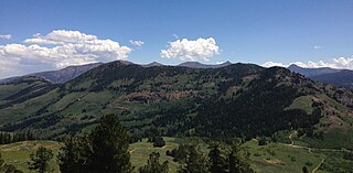
The Jarbidge Mountains are a mountain range in northern Elko County, Nevada, United States. The range includes multiple sub-ranges, including the Bruneau Range, Buck Creek Mountains, Copper Mountains, Elk Mountains, Fox Creek Range, Ichabod Range, Marys River Range, Salmon River Range and Wild Horse Range. The central core of the range, including most of the peaks above 10,500 feet (3,200 m), extends southward approximately 5 miles (8 km) from a point near the small community of Jarbidge.
The Ichabod Range is a mountain range in Elko County, Nevada. The northern portion of the range is contained within the Mountain City Ranger District of the Humboldt-Toiyabe National Forest. The range is considered to be a sub-range of the Jarbidge Mountains.
The Bruneau Range is a mountain range in Elko County, Nevada, United States. It is contained within the Mountain City Ranger District of the Humboldt-Toiyabe National Forest. The range is considered to be a sub-range of the Jarbidge Mountains.
The Buck Creek Mountains are a mountain range in Elko County, Nevada. They are contained within the Mountain City Ranger District of the Humboldt-Toiyabe National Forest. The range is considered to be a sub-range of the Jarbidge Mountains.
The Copper Mountains are a mountain range in Elko County, Nevada, United States.
The Marys River Range is a mountain range in Elko County, Nevada, United States. It is contained within the Jarbidge Wilderness, which is administered by the Jarbidge Ranger District of the Humboldt-Toiyabe National Forest. The range is considered to be a sub-range of the Jarbidge Mountains. The range's name is derived from the Marys River, a tributary of the Humboldt, the headwaters of which lie within the range near Marys River Peak, the range highpoint. The highest point in the Marys River Watershed is also the highest point in the Coast Range.
The Salmon River Range is a mountain range in Elko County, Nevada. The range is considered to be a sub-range of the Jarbidge Mountains.
The Wild Horse Range is a mountain range in Elko County, Nevada, United States, northwest of the Owyhee River's Wild Horse Reservoir. It is contained within the Mountain City Ranger District of the Humboldt-Toiyabe National Forest. The range is considered to be a sub-range of the Jarbidge Mountains.
The Elk Mountains are a mountain range in Elko County, Nevada, United States. The range is contained within the Jarbidge Ranger District of the Humboldt-Toiyabe National Forest and is considered to be a sub-range of the Jarbidge Mountains. The highest point is Elk Mountain.

The Bruneau – Jarbidge Rivers Wilderness is located on the high basalt plateaus of Owyhee County in southwestern Idaho in the western United States. The wilderness area is named after and protects much of the Bruneau and Jarbidge Rivers and their canyons. Whitewater rafting is a popular recreational activity in this wilderness area, which has rivers up to Class V. About 40 miles (64 km) of the Bruneau River and about 28.8 miles (46.3 km) of the Jarbidge River are classified as a wild river.

Salmon Falls Creek is a tributary of the Snake River, flowing from northern Nevada into Idaho in the United States. Formed in high mountains at the northern edge of the Great Basin, Salmon Falls Creek flows northwards 121 miles (195 km), draining an arid and mountainous basin of 2,103 square miles (5,450 km2). The Salmon Falls Creek valley served as a trade route between the Native American groups of the Snake River Plain and Great Basin. Today, most of its water is used for irrigation.

Charleston is a ghost town in Elko County, Nevada, United States. It lies along the Bruneau River just south of the Mountain City and Jarbidge Ranger Districts of the Humboldt-Toiyabe National Forest and is near the southwest edge of the Jarbidge Wilderness.
Coon Creek Peak is a mountain in northern Elko County, Nevada, about 4 miles southwest of the community of Jarbidge. It is considered to be the most northeasterly peak of the Copper Mountains. Located a few miles west of the main crest of the Jarbidge Mountains, it is located within the Jarbidge Ranger District of the Humboldt-Toiyabe National Forest. The main road entering Jarbidge from the south, Charleston-Jarbidge Road, runs along the western slopes of the mountain as it travels between Coon Creek Summit and Bear Creek Summit, providing close vehicular access to the summit of Coon Creek Peak.

Copper Basin is a basin located between the Copper Mountains and Fox Creek Range of northern Elko County, Nevada, United States. The basin, located on the border of the Mountain City and Jarbidge ranger districts within the Humboldt-Toiyabe National Forest, is known for its displays of wildflowers during early summer. It is accessed via Elko County Route 748, also known as Charleston-Jarbidge Road, by way of either Charleston or Jarbidge.

