Foxholm, North Dakota

Last updated

Foxholm, North Dakota
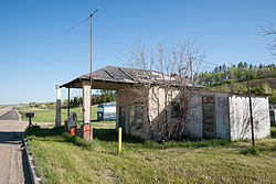
Foxholm Foxholm, North Dakota 5-30-2009.jpg
Abandoned Gas Station in Foxholm
USA North Dakota location map.svg
Red pog.svg
Foxholm, North Dakota
Coordinates: 48°21′55″N101°34′20″W / 48.36528°N 101.57222°W / 48.36528; -101.57222
Country United States
State North Dakota
County Ward
Area
[1]
  Total
0.96 sq mi (2.48 km2)
  Land0.96 sq mi (2.48 km2)
  Water0.00 sq mi (0.00 km2)
Elevation
[2]
1,677 ft (511 m)
Population
 (2020)
  Total
56
  Density58.39/sq mi (22.54/km2)
Time zone UTC-6 (Central (CST))
  Summer (DST) UTC-5 (CDT)
Area code 701
GNIS feature ID2584343 [2]

Foxholm is a census-designated place and unincorporated community in Ward County, North Dakota, United States. Its population was 75 as of the 2010 census. [3]

Contents

Foxholm is located along U.S. Route 52, 18 miles (29 km) northwest of Minot and 76 miles (122 km) southeast of the Saskatchewan and North Dakota border at Portal, ND/North Portal, SK. Foxholm is in the Des Lacs River Valley.

History

A post office called Foxholm was established in 1894, and remained in operation until 1967. [4] The community supposedly was named after a place in England. [5] The population was 250 in 1940. [6]

Demographics

Historical population
CensusPop.Note
2020 56
U.S. Decennial Census [7]

References

  1. "ArcGIS REST Services Directory". United States Census Bureau. Retrieved September 20, 2022.
  2. 1 2 U.S. Geological Survey Geographic Names Information System: Foxholm, North Dakota
  3. "U.S. Census website". United States Census Bureau . Retrieved May 14, 2011.
  4. "Ward County". Jim Forte Postal History. Retrieved October 22, 2015.
  5. Federal Writers' Project (1938). North Dakota, a Guide to the Northern Prairie State. WPA. p. 275. ISBN   978-1-62376-033-5.{{cite book}}: ISBN / Date incompatibility (help)
  6. The Attorneys List. United States Fidelity and Guaranty Company, Attorney List Department. 1940. p. 718.
  7. "Census of Population and Housing". Census.gov. Retrieved June 4, 2016.