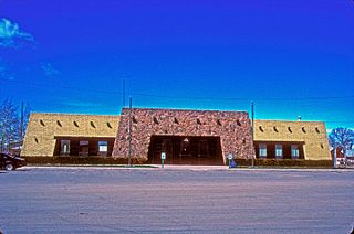
Conejos County is one of the 64 counties of the U.S. state of Colorado. As of the 2010 census, the population was 8,256. The county seat is the unincorporated community of Conejos.

Frances Wright also widely known as Fanny Wright, was a Scottish-born lecturer, writer, freethinker, feminist, abolitionist, and social reformer, who became a US citizen in 1825. The same year, she founded the Nashoba Commune in Tennessee, as a utopian community to prepare slaves for emancipation, but it lasted only five years. Her Views of Society and Manners in America (1821) brought her to public attention as a critic of the new nation.

United Way of America based in Alexandria, Virginia, is a nonprofit organization that works with almost 1,200 local United Way offices throughout the country in a coalition of charitable organizations to pool efforts in fundraising and support. United Way's focus is to identify and resolve pressing community issues and to make measurable changes in communities through partnerships with schools, government agencies, businesses, organized labor, financial institutions, community development corporations, voluntary and neighborhood associations, the faith community, and others. The main areas include education, income, and health.

Frances Xavier Cabrini, also called Mother Cabrini, was an Italian-American religious sister, who founded the Missionary Sisters of the Sacred Heart of Jesus, a Catholic religious institute that was a major support to the Italian immigrants to the United States. She was the first naturalized citizen of the United States to be canonized by the Roman Catholic Church, on July 7, 1946.
A census-designated place (CDP) is a concentration of population defined by the United States Census Bureau for statistical purposes only. CDPs have been used in each decennial census since 1980 as the counterparts of incorporated places, such as self-governing cities, towns, and villages, for the purposes of gathering and correlating statistical data. CDPs are populated areas that generally include one officially designated but currently unincorporated small community, for which the CDP is named, plus surrounding inhabited countryside of varying dimensions and, occasionally, other, smaller unincorporated communities as well. CDPs include small rural communities, colonias located along the U.S. border with Mexico, and unincorporated resort and retirement communities and their environs.

Hurricane Frances was the second most intense tropical cyclone in the Atlantic during 2004 that proved to be very destructive in Florida. The sixth named storm, the fourth hurricane, and the third major hurricane of the 2004 Atlantic hurricane season. The system crossed the open Atlantic in mid and late August, moving to the north of the Lesser Antilles while strengthening. Its outer bands struck Puerto Rico and the British Virgin Islands while passing north of the Caribbean Sea. The storm's maximum sustained wind peaked at 145 mph (233 km/h), achieving Category 4 on the Saffir-Simpson Hurricane Scale. As the system's forward motion slowed, the eye passed over San Salvador Island and very close to Cat Island in the Bahamas. Frances was the first hurricane to impact the entire Bahamian archipelago since 1928, and almost completely destroyed the agricultural economy there.

Fort Frances is a town in, and the seat of, Rainy River District in Northwestern Ontario, Canada. The population as of the 2016 census was 7,739. Fort Frances is a popular fishing destination. It hosts the annual Fort Frances Canadian Bass Championship.

Saunderstown is a small village and historic district in the towns of Narragansett and North Kingstown in Washington County, Rhode Island, United States.
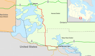
King's Highway 71, commonly referred to as Highway 71, is a provincially maintained highway in the Canadian province of Ontario. The 194-kilometre-long (121 mi) route begins at the Fort Frances–International Falls International Bridge in Fort Frances, continuing from US Route 53 (US 53) and US Route 71 (US 71) in Minnesota, and travels west concurrently with Highway 11 for 40 kilometres (25 mi) to Chapple. At that point, Highway 11 continues west while Highway 71 branches north and travels 154 kilometres (96 mi) to a junction with Highway 17 just east of Kenora. Highway 71 is part of the Trans-Canada Highway for its entire length.
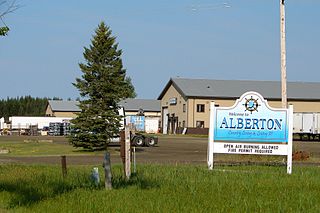
The Township of Alberton is a community in the Rainy River District of Northwestern Ontario, Canada. It is made up of the two geographic townships Crozier and Roddick. The township borders Fort Frances to the east, La Vallee to the west, the unincorporated geographical township of Miscampbell to the north, and the city of International Falls to the south.

Salt Point is a hamlet and census-designated place (CDP) in Dutchess County, New York, United States. As of the 2010 census it had a population of 190. It lies northeast of Poughkeepsie following New York Route 115, the Salt Point Turnpike. East of Salt Point, the Taconic State Parkway allows for access to many of the surrounding towns and communities, with easy travel to New York City. The area code is 845 and the exchange is COlfax6.

Frances Slocum State Park is a 1,035-acre (419 ha) Pennsylvania state park in Kingston Township, Luzerne County, Pennsylvania, in the United States. Frances Slocum Lake is a 165-acre (67 ha) man-made, horseshoe-shaped lake that is a popular fishing and boating destination. The park is 5 miles (8.0 km) from Dallas and 10 miles (16 km) from Wilkes-Barre.
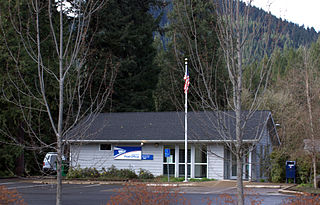
Blue River is an unincorporated community in Lane County, Oregon, United States. It is located on Oregon Route 126 along the McKenzie River, between the communities of Finn Rock and Rainbow. It is in the Willamette National Forest, where the Blue River empties into the McKenzie. The community is named after the Blue River, which is named for the striking blue color that apparently comes from its rocky bed. Five miles northeast of the community, a dam on the Blue River forms the Blue River Reservoir.

Peoria is an unincorporated community in Butler Township, Miami County, in the U.S. state of Indiana.
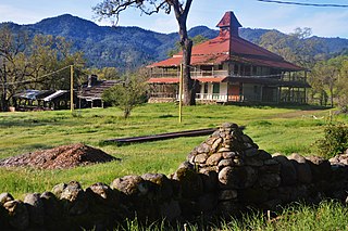
Aetna Springs is an unincorporated community in Napa County, California, United States. It lies at an elevation of 771 feet. The ZIP Code is 94567. The community is inside area code 707.
The Franciscan Sisters of the Poor are a religious congregation which was established in 1959 as an independent branch from the Congregation of the Poor Sisters of St. Francis, founded in Germany by Blessed Frances Schervier in 1845.

Esmont is a census-designated place (CDP) in Albemarle County, Virginia, United States. The population as of the 2010 Census was 528.

Marfrance is an unincorporated community and coal town in Greenbrier County, West Virginia, United States. Marfrance is 1 mile (1.6 km) east of Quinwood.

The Church of St. Frances of Rome is a Roman Catholic parish church under the authority of the Roman Catholic Archdiocese of New York, located at 4307 Barnes Avenue Bronx, New York City. The parish was established in 1898.

Hatchville is a neighborhood within the town of Falmouth, Massachusetts, on Cape Cod in the United States. The mailing address for the area is East Falmouth, to the south of Hatchville.


