
The Ellesmere Canal was a waterway in England and Wales that was planned to carry boat traffic between the rivers Mersey and Severn. The proposal would create a link between the Port of Liverpool and the mineral industries in north east Wales and the manufacturing centres in the West Midlands. However, the canal was never completed as intended because of its rising costs and failure to generate the expected commercial traffic.

The Llangollen Canal is a navigable canal crossing the border between England and Wales. The waterway links Llangollen in Denbighshire, north Wales, with Hurleston in south Cheshire, via the town of Ellesmere, Shropshire. The name, which was coined in the 1980s, is a modern designation for parts of the historic Ellesmere Canal and the Llangollen navigable feeder, both of which became part of the Shropshire Union Canals in 1846.

The Shropshire Union Canal, nicknamed the "Shroppie", is a navigable canal in England. The Llangollen and Montgomery canals are the modern names of branches of the Shropshire Union (SU) system and lie partially in Wales.
The Chester Canal was an English canal linking the south Cheshire town of Nantwich with the River Dee at Chester. It was intended to link Chester to Middlewich, with a branch to Nantwich, but the Trent and Mersey Canal were unco-operative about a junction at Middlewich, and so the route to Nantwich was opened in 1779. There were also difficulties negotiating with the River Dee Company, and with no possibility of through traffic, the canal was uneconomic. Part of it was closed in 1787, when Beeston staircase locks collapsed, and there was no money to fund repairs. When the Ellesmere Canal was proposed in 1790, the company saw it as a ray of hope, and somehow managed to keep the struggling canal open. The Ellesmere Canal provided a link to the River Mersey at Ellesmere Port from 1797, and the fortunes of the Chester Canal began to improve.

Horseshoe Falls is a weir on the River Dee near Llantysilio Hall in Denbighshire, Wales, about 5 kilometres (3 mi) north-west of the town of Llangollen.

The Montgomery Canal, known colloquially as "The Monty", is a partially restored canal in eastern Powys and northwest Shropshire. The canal runs 33 miles (53 km) from the Llangollen Canal at Frankton Junction to Newtown via Llanymynech and Welshpool and crosses the England–Wales border.
The Shrewsbury Canal was a canal in Shropshire, England. Authorised in 1793, the main line from Trench to Shrewsbury was fully open by 1797, but it remained isolated from the rest of the canal network until 1835, when the Birmingham and Liverpool Junction Canal built the Newport Branch from Norbury Junction to a new junction with the Shrewsbury Canal at Wappenshall. After ownership passed to a series of railway companies, the canal was officially abandoned in 1944; many sections have disappeared, though some bridges and other structures can still be found. There is an active campaign to preserve the remnants of the canal and to restore the Norbury to Shrewsbury line to navigation.

Norbury Junction is a canal junction which lies about 1 mile (1.6 km) to the south east of Norbury, in Staffordshire, England. It opened in 1835, and closed in 1944, although the main line of the Shropshire Union Canal still runs through it.
The Shropshire Union Railways and Canal Company was a Company in England, formed in 1846, which managed several canals and railways. It intended to convert a number of canals to railways, but was leased by the London and North Western Railway (LNWR) from 1847, and although they built one railway in their own right, the LNWR were keen that they did not build any more. They continued to act as a semi-autonomous body, managing the canals under their control, and were critical of the LNWR for not using the powers which the Shropshire Union Company had obtained to achieve domination of the markets in Shropshire and Cheshire by building more railways.

The Four Counties Ring is a canal ring which links the four English counties of Cheshire, Staffordshire, Shropshire and the West Midlands.
The Middlewich Branch of the Shropshire Union Canal is located in Cheshire, in the north west of England, and runs between Middlewich, where it joins the Trent and Mersey Canal, and Barbridge Junction, where it joins the main line of the Shropshire Union Canal. It is 10 miles (16 km) long, and was planned as part of the Chester Canal, which was authorised in 1772, but the company ran out of money, and construction did not begin until 1827. The Trent and Mersey insisted that there should be no direct connection at Middlewich, and instead built the short Wardle Canal to join the two, charging large compensation tolls for traffic passing along it.

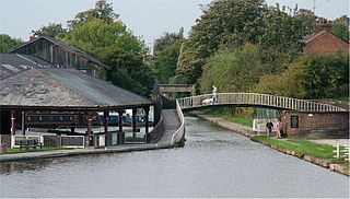
Hurleston Junction is the name of the canal junction where the Llangollen Canal terminates and meets the Shropshire Union Canal main line at Hurleston, Cheshire, England.
Montgomery Waterway Restoration Trust is a British registered charity, number 510448, which exists to promote the restoration of the Montgomery Canal.

Horseley Fields Junction is a canal junction at the western limit of the Wyrley and Essington Canal where it meets the BCN Main Line, at Horseley Fields east of Wolverhampton, in the West Midlands, England.
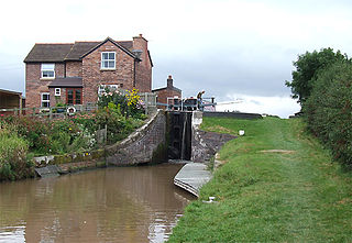
Barbridge Junction is the name of the canal junction located at Barbridge, Cheshire, where the Shropshire Union Canal Middlewich Branch terminates and meets the Shropshire Union Canal main line.

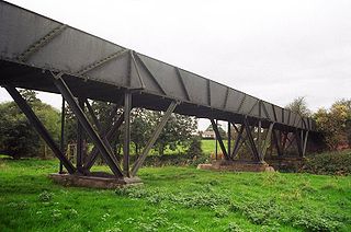
Wappenshall Junction is a British canal junction located at Wappenshall, Shropshire. It was created when the Newport Branch Canal joined the Shrewsbury Canal in 1835, and was closed along with the canal in 1944.
The Montgomery Dinghy Dawdle was an event held annually between 1985 and 2011 to promote use and awareness of the Montgomery Canal, and to highlight the road bridges which had been lowered. It involved unpowered craft such as dinghies, canoes and coracles travelling along the canal. Early events involved stopping the traffic and carrying boats over a road where a low bridge prevented using the canal. Increasing difficulty with supervising this aspect of the event led to it being held on sections that did not involve crossing roads, and so it became a social event, rather than a campaigning tool. This led the organisers, the Shropshire Union Canal Society, to cancel the event after 2011, but the Friends of the Montgomery Canal took it over, and turned it into a triathlon, with cycling, walking or running, and paddling, covering the whole length of the canal.

Delph Locks or the Delph Nine are a series of eight narrow canal locks on the Dudley No. 1 Canal in Brierley Hill, in the West Midlands, England. They were opened in 1779, and reopened in 1967 following restoration of the Dudley Canal and the Stourbridge Canal in a joint venture between the Staffordshire and Worcestershire Canal Society and the British Waterways Board.
The Birmingham and Liverpool Junction Canal was a canal in England which ran from Nantwich, where it joined the Chester Canal, to Autherley, where it joined the Staffordshire and Worcestershire Canal. Forming part of a major link between Liverpool and the industrial heartlands of the Midlands, the canal was opened in 1835, and merged with the Ellesmere and Chester Canal Company in 1845, which became the Shropshire Union Railways and Canal Company in the following year.

The Runcorn and Weston Canal was a short canal near Runcorn in Cheshire, England, constructed to link the Weston Canal, which is part of the River Weaver Navigation, to the Bridgewater Canal and Runcorn Docks. It was completed in 1859, but was little used. Around half of it became the Arnold Dock in 1876, when it was made wider and deeper, and linked to Fenton Dock by a ship lock. The dock section and some of the remaining canal were filled in during the 1960s, and the remainder is in a derelict state.

