Frankton, Hamilton

Last updated

Frankton
1980 Frankton Junction, Hamilton.jpg
Frankton Junction in 1980, showing 1975 station and site of the previous station (bottom centre).
Frankton, Hamilton
Coordinates: 37°47′20″S175°15′36″E / 37.789°S 175.260°E / -37.789; 175.260
CountryNew Zealand
City Hamilton, New Zealand
Local authority Hamilton City Council
Electoral wardWest Ward
Established1913
Area
[1]
  Land483 ha (1,194 acres)
Population
 (June 2022) [2]
  Total7,370
Livingstone Maeroa Whitiora
Dinsdale
Pfeil oben.svg
Pfeil links.svgFranktonPfeil rechts.svg
Pfeil unten.svg
Hamilton Central
Temple View Melville Lake Rotoroa

Frankton is a central suburb of the city of Hamilton, New Zealand. It is the site of the city's passenger railway station, a major industrial-commercial stretch of State Highway 1C, and a commercial shopping area. Frankton Borough Council was formed in 1913, but merged with Hamilton in 1917, [3] after a poll in 1916. [4]

Contents

Demographics

Frankton covers 4.83 km2 (1.86 sq mi) [1] and had an estimated population of 7,370 as of June 2022, [2] with a population density of 1,526 people per km2.

Historical population
YearPop.±% p.a.
20064,788    
20135,169+1.10%
20186,504+4.70%
Source: [5]
Frankton Hotel, Commerce Street Frankton Hotel, Commerce Street.jpg
Frankton Hotel, Commerce Street

Frankton had a population of 6,504 at the 2018 New Zealand census, an increase of 1,335 people (25.8%) since the 2013 census, and an increase of 1,716 people (35.8%) since the 2006 census. There were 2,319 households, comprising 3,207 males and 3,312 females, giving a sex ratio of 0.97 males per female, with 1,473 people (22.6%) aged under 15 years, 1,902 (29.2%) aged 15 to 29, 2,628 (40.4%) aged 30 to 64, and 507 (7.8%) aged 65 or older.

Ethnicities were 54.1% European/Pākehā, 35.7% Māori, 9.9% Pacific peoples, 17.7% Asian, and 3.0% other ethnicities. People may identify with more than one ethnicity.

The percentage of people born overseas was 23.8, compared with 27.1% nationally.

Although some people chose not to answer the census's question about religious affiliation, 47.3% had no religion, 33.3% were Christian, 2.0% had Māori religious beliefs, 4.4% were Hindu, 1.8% were Muslim, 1.2% were Buddhist and 3.6% had other religions.

Of those at least 15 years old, 942 (18.7%) people had a bachelor's or higher degree, and 951 (18.9%) people had no formal qualifications. 366 people (7.3%) earned over $70,000 compared to 17.2% nationally. The employment status of those at least 15 was that 2,598 (51.6%) people were employed full-time, 549 (10.9%) were part-time, and 408 (8.1%) were unemployed. [5]

Individual statistical areas
NameArea
(km2)
PopulationDensity
(per km2)
HouseholdsMedian ageMedian
income
Swarbrick0.512,4004,70696629.6 years$27,000 [6]
Kahikatea0.983,4653,5361,12228.6 years$28,700 [7]
Frankton Junction3.3463919123131.9 years$28,800 [8]
New Zealand37.4 years$31,800

Railway

Frankton is the location of Hamilton's main passenger railway station. The station is sited at the junction of the North Island Main Trunk line (NIMT) and the East Coast Main Trunk line, but passenger services on the East Coast line were discontinued and only the twice a day, Te Huia and the six days a week, Auckland and Wellington, Northern Explorer passenger trains stop. [9] The station was formerly called Frankton Junction, a very important railway station, [10] and included the now-closed Frankton Tea Rooms, where passenger trains without dining cars would stop to allow passengers to purchase food and drinks. Many workshops and railway workers homes were in the area west of the railway. [11]

Commerce Street

The main street of Frankton, Commerce Street, and the streets surrounding it, form one of Hamilton City's largest suburban non-mall shopping areas. The area is dominated by the well-known, locally owned department store, Forlongs Furnishings of Frankton, established in 1946. In 2015 it closed, but reopened in 2016 in part of the store, as a furniture shop in Rawhiti Street [12] and further expanded back into part of its Commerce Street store in 2018. [13]

Hotels

Four hotels once stood near the railway station. Two were to the west in Colombo Street [14] and two on the other side of the line on High St.

Frankton Hotel

Frankton Hotel remains on the corner of Commerce and High Streets. It was built in 1929 as a 35-room hotel [15] to a design by Jack Chitty [16] and is listed as a category 2 historic place. [17] An earlier hotel was moved about 75 ft (23 m) by horses to make way for the current building. [18] During the move, the bar was in a temporary shed. [19]

Empire Hotel

The New Empire Hotel was on the corner of Empire and High Streets. It was renovated in 1974, the original Empire Hotel having been built in February 1913. [20] In 1995 it was burnt down by an arsonist, killing six residents. [21] In 1946 the Grand Hotel on Colombo St had also burnt down. [22]

Industry

Frankton has long been one of Hamilton's industrial centres. [23] In addition to the Railway House Factory, another major employer was a factory on a 3.4 ha (8.4 acres) site, beside the railway, on the corner of Massey and Lincoln streets, [23] specializing in brawn, sausages and polonies [24] from 1901 [25] to 2014. Pigs were slaughtered there from 1911 to 1999. It had a railway siding from 1912 until the 1990s. The factory had several owners, including Waikato Farmers' Bacon Co, [26] W.Dimock & Co Ltd [27] and J.C.Hutton Australia from 1926 to 1986. Hutton's then merged with Kiwi Bacon Co to become Hutton's Kiwi. [24] In 2007 Goodman Fielder were warned for misleading labels, as some of its pork was imported. [28] In 2014 they sold their meat brands to Hellers and 125 staff lost their jobs. [29]

Frankton had dairy factories from 1894 [30] and still has a cool store in the former dairy and bacon factories. [31]

V8 Supercars

The New Zealand leg of the Australian V8 Supercars centred on Hamilton Street Circuit in and around Frankton, yearly from April 2008 to 2012.

Tornado

Frankton Tornado, August 1948 Frankton Tornado, August 1948 (20737069362).jpg
Frankton Tornado, August 1948

Three people were killed, seven victims were badly injured and damage to property was heavy after a tornado swept across Hamilton from the north-west shortly before midday on Wednesday 25 August 1948. [32]

The tornado, which appears to have originated in the Frankton or Forest Lake area, went through the business area of Frankton then over the hill into Hamilton West where it passed between Hamilton Lake and Victoria Street (the main street). Then, it travelled across the Waikato River to Hamilton East where damage occurred in Wellington, Naylor and Grey streets.

Buildings were lifted off their piles, chimneys were snapped off, houses were unroofed, trees uprooted, and power and telephone lines were left hanging in the streets. The air was filled with flying corrugated iron, branches of trees, timber and other debris. Heavy rain accompanied the storm and overhead lightning flashed and thunder boomed. The storm passed quickly and was succeeded by a strange calm.

Education

Rhode Street School is a full primary school for years 1 to 8 with a roll of 196 students. [33] It was established in 1959. [34]

Frankton School is a contributing primary school for years 1 to 6 with a roll of 666 students. [35] Frankton School opened in 1911 [36]

Both schools are coeducational. Rolls are as of April 2023. [37]

See also

Related Research Articles

<span class="mw-page-title-main">Hamilton, New Zealand</span> City in North Island, New Zealand

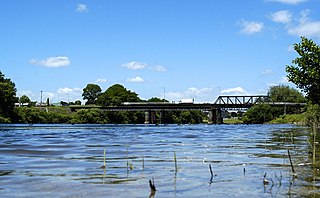
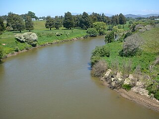
Hamilton is an inland city in the North Island of New Zealand. Located on the banks of the Waikato River, it is the seat and most populous city of the Waikato region. With a territorial population of 185,300, it is the country's fourth most-populous city. Encompassing a land area of about 110 km2 (42 sq mi), Hamilton is part of the wider Hamilton Urban Area, which also encompasses the nearby towns of Ngāruawāhia, Te Awamutu and Cambridge. In 2020, Hamilton was awarded the title of most beautiful large city in New Zealand.

<span class="mw-page-title-main">Ngāruawāhia</span> Town in Waikato, New Zealand

Ngāruawāhia is a town in the Waikato region of the North Island of New Zealand. It is located 20 kilometres (12 mi) north-west of Hamilton at the confluence of the Waikato and Waipā Rivers, adjacent to the Hakarimata Range. Ngāruawāhia is in the Hamilton Urban Area, the fourth largest urban area in New Zealand. The location was once considered as a potential capital of New Zealand.

<span class="mw-page-title-main">Tīrau</span> Settlement in Waikato, New Zealand

Tīrau is a small town in the Waikato region of the North Island of New Zealand, 50 kilometres southeast of Hamilton. The town has a population of 804. In the Māori language, "Tīrau" means "place of many cabbage trees."

<span class="mw-page-title-main">Putāruru</span> Town in Waikato, New Zealand

Putāruru is a small town in the South Waikato District and the Waikato region of New Zealand's North Island. It lies on the western side of the Mamaku Ranges and in the upper basin of the Waihou River. It is on the Oraka Stream 65 kilometres south-east of Hamilton. State Highway 1 and the Kinleith Branch railway run through the town.

<span class="mw-page-title-main">Te Rapa</span> Suburb of Hamilton, New Zealand

Te Rapa is a mixed light industrial, large-scale retail and semi-rural suburb to the northwest of central Hamilton, New Zealand that is built on a flat area that was previously the bed of an ancient river, the forerunner to the present Waikato River.

<span class="mw-page-title-main">Hamilton East, New Zealand</span> Suburb of Hamilton, New Zealand

Hamilton East is a suburb in central Hamilton in New Zealand. The suburb's primary commercial and retail precinct is located along Grey Street. Hamilton East is characterised by villas and bungalows built early in the 20th century.

<span class="mw-page-title-main">Rototuna</span> Suburb of Hamilton, New Zealand

Rototuna is a suburb in northern Hamilton, New Zealand, east of Flagstaff. It is one of the newest and fastest-growing suburbs in Hamilton, along with neighbouring Huntington and Flagstaff.

The Cambridge Branch is a rural railway line in the Waikato, New Zealand. The line stretches from Ruakura Junction for 15.08 kilometres (9.37 mi) to the settlement of Hautapu, having previously continued another 4.19 kilometres (2.60 mi) to the township of Cambridge. It had five stations along its length, at Newstead, Matangi (Tamahere), Bruntwood (Fencourt), Hautapu and the terminus at Cambridge.

<span class="mw-page-title-main">Hinuera</span> Settlement in Waikato, New Zealand

Hinuera is a settlement in the Waikato Region of New Zealand's North Island. It is located along State Highway 29, approximately halfway between the cities of Hamilton and Tauranga. It also contains the Hinuera cliffs along State Highway 29.

<span class="mw-page-title-main">Enderley</span> Suburb of Hamilton, New Zealand

Enderley is a suburb of Hamilton, New Zealand. It became a part of Hamilton in the 5th boundary extension in 1949. It is the highest ranking suburb for socio-economic deprivation in eastern Hamilton.

<span class="mw-page-title-main">Whitiora</span> Suburb of Hamilton, New Zealand

Whitiora is a suburb in central Hamilton in New Zealand. The suburb is home to Waikato Stadium, formerly Rugby Park. It is a major sporting and cultural events venue in Hamilton with a total capacity of 25,800. The stadium is a multi-purpose facility, though used mainly for rugby union. Many of Hamilton's hotels are in Whitiora, along the main road from the north.

<span class="mw-page-title-main">Hamilton City Council (New Zealand)</span>

Hamilton City Council is the territorial authority for the New Zealand city of Hamilton.

<span class="mw-page-title-main">Whatawhata</span> Town in Waikato, New Zealand

Whatawhata, previously also spelt Whata Whata, is a small town in the Waikato region on the east bank of the Waipā River, at the junction of State Highways 23 and 39, 12 km (7.5 mi) from Hamilton. Te Araroa tramping route passes through Whatawhata.

State Highway 23 (SH 23) is a New Zealand state highway that connects the towns of Raglan and Hamilton.

<span class="mw-page-title-main">Hamilton railway station, New Zealand</span> Railway station in New Zealand

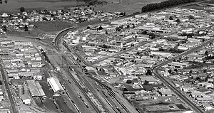
Hamilton railway station serves the city of Hamilton in the Waikato region of New Zealand. It is located in the suburb of Frankton, hence the station's former name Frankton Junction, its name for most of its existence. The station is a Keilbahnhof, located at the junction of the North Island Main Trunk (NIMT) and East Coast Main Trunk (ECMT) lines. The station is served by the regional Te Huia service, which runs to Auckland via Rotokauri Transport Hub and Huntly railway station twice daily in the morning, with return services in the evening.

<span class="mw-page-title-main">Public transport in Waikato</span> Public transport operator in the Waikato region, New Zealand

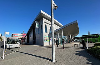
Public transport in Hamilton and the Waikato Region serves most of the urban centres. Initially boats carried passengers, then coaches, railways and now almost entirely buses. Services are mainly infrequent and investment hasn't been sufficient to compete with cars, so that subsidies, first introduced in 1971, have increased.

Horotiu is a small township on the west bank of the Waikato River in the Waikato District of New Zealand. It is on the Waikato Plains 13 km (8.1 mi) north of Hamilton and 5 km (3.1 mi) south of Ngāruawāhia. From early in the 20th century it developed around a freezing works and other industries.

<span class="mw-page-title-main">Hamilton Central railway station, New Zealand</span> Defunct railway station in New Zealand

Hamilton Central was the name of a now-defunct railway station on the East Coast Main Trunk line which runs through the city of Hamilton in the Waikato region of New Zealand. The station was located in Hamilton's CBD and was made an underground station for the latter years of its existence before being closed. The underground platform still exists.

<span class="mw-page-title-main">Motumaoho</span> Village in Waikato, New Zealand

Motumaoho is a small village in the Waikato region of New Zealand's North Island, just to the west of the Pakaroa Range. It is on SH26, 25 km (16 mi) east of Hamilton and 7 km (4.3 mi) west of Morrinsville. The village is bordered by the Waitakaruru Stream to the east. Motumaoho can be translated as an intruding clump of trees.

References

  1. 1 2 "ArcGIS Web Application". statsnz.maps.arcgis.com. Retrieved 20 October 2022.
  2. 1 2 "Population estimate tables - NZ.Stat". Statistics New Zealand . Retrieved 25 October 2022.
  3. Waikato Times 27 November 2013
  4. New Zealand Herald 19 May 1916
  5. 1 2 "Statistical area 1 dataset for 2018 Census". Statistics New Zealand. March 2020. Swarbrick (178700), Kahikatea (178800) and Frankton Junction (178900).
  6. 2018 Census place summary: Swarbrick
  7. 2018 Census place summary: Kahikatea
  8. 2018 Census place summary: Frankton Junction
  9. "New services added to Te Huia timetable". www.waikatoregion.govt.nz. 20 October 2023. Retrieved 4 December 2023.
  10. Oliver, Stacey (13 October 2015). "Frankton is the Cinderella of Hamilton". Stuff. Retrieved 22 May 2023.
  11. Lines-MacKenzie, Jo (26 February 2021). "Opening the door on Frankton's Railway Village". Stuff. Retrieved 22 May 2023.
  12. Wilkie, Kelsey (2 June 2016). "Forlongs reopens under new ownership in Hamilton as a smaller store". Stuff. Retrieved 12 April 2018.
  13. Davis, Gill (29 November 2017). "Closed Forlongs department store rents out half its Frankton retail spaces". Stuff. Retrieved 13 April 2018.
  14. "Charles Lafferty's Junction and Grand Hotels, Frankton Junction". National Library of New Zealand. 1 January 1923. Retrieved 24 March 2020.
  15. "NEW FRANKTON HOTEL. NEW ZEALAND HERALD". paperspast.natlib.govt.nz. 1 April 1929. Retrieved 24 March 2020.
  16. "Funded project: Frankton Hotel". Heritage EQUIP. Retrieved 24 March 2020.
  17. "Frankton Hotel". www.heritage.org.nz. Retrieved 24 March 2020.
  18. "Frankton Hotel". www.franktonhotel.co.nz. Retrieved 24 March 2020.
  19. "LOCAL AND GENERAL. WAIKATO TIMES". paperspast.natlib.govt.nz. 15 June 1929. Retrieved 24 March 2020.
  20. "New Empire Hotel". Hamilton Libraries Heritage Collection Online. Retrieved 24 March 2020.
  21. "Empire Hotel fire, 1995". teara.govt.nz. Retrieved 24 March 2020.
  22. "Frankton Hotel Destroyed By Fire NORTHERN ADVOCATE". paperspast.natlib.govt.nz. 3 January 1946. Retrieved 24 March 2020.
  23. 1 2 "The Frankton Neighbourhood Plan" (PDF). Hamilton City Council. 2014.
  24. 1 2 "Hutton's history ready to be written". NZ Herald. Retrieved 6 July 2017.
  25. "WAIKATO BACON COMPANY'S FACTORY. (Waikato Argus, 1901-10-23)". paperspast.natlib.govt.nz National Library of New Zealand. Retrieved 6 July 2017.
  26. "A BACON VENTURE (Manawatu Times, 1926-06-10)". paperspast.natlib.govt.nz National Library of New Zealand. Retrieved 6 July 2017.
  27. "AMALGAMATED BACON COMPANIES (Waikato Times, 1916-09-09)". paperspast.natlib.govt.nz National Library of New Zealand. Retrieved 6 July 2017.
  28. "Companies warned over bacon and ham labelling | Commerce Commission". www.comcom.govt.nz. Retrieved 6 July 2017.
  29. "Gates closed on Hutton workers". www.firstunion.org.nz. Retrieved 6 July 2017.
  30. "Frankton Butter Factory". Hamilton Libraries Heritage Collection Online. Retrieved 3 July 2021.
  31. "Cool Storage Express" . Retrieved 3 July 2021.
  32. NZ Disasters and Tragedies
  33. Education Counts: Rhode Street School
  34. "Rhode Street School". Rhode Street School. Retrieved 22 October 2020.
  35. Education Counts: Frankton School
  36. "History of Frankton School". Frankton School. Retrieved 17 October 2020.
  37. "New Zealand Schools Directory". New Zealand Ministry of Education. Retrieved 12 December 2022.