Silverdale, Hamilton

Last updated

Silverdale
SilverdaleHamilton2.jpg
Silverdale, from the University of Waikato.
Silverdale, Hamilton
Coordinates: 37°47′33.7″S175°19′42.65″E / 37.792694°S 175.3285139°E / -37.792694; 175.3285139
CountryNew Zealand
City Hamilton, New Zealand
Local authority Hamilton City Council
Electoral wardEast Ward
Established1962
Area
[1]
  Land80 ha (200 acres)
Population
 (June 2022) [2]
  Total2,340
Ruakura
Hillcrest
Pfeil oben.svg
Pfeil links.svgSilverdalePfeil rechts.svg
Pfeil unten.svg
Riverlea

Silverdale is a suburb in south-eastern Hamilton in New Zealand. It is east from Hillcrest and home to Hillcrest High School, despite the school's name. Part of Silverdale is covered by the University of Waikato.

Contents

History

It was named Silverdale after the original farm on the land, which itself was named after the shining silver poplar leaves. [3]

Features of Silverdale

The suburb forms a large part of the University of Waikato's commercial, residential and educational hinterland. Jansen Park, located between Morrinsville Rd and Masters Ave, is the biggest park in the area and is used by Hillcrest United and Waikato Unicol Football soccer during the winter season. The main suburban shopping centre is located on Silverdale Rd.

Demographics

Silverdale covers 0.80 km2 (0.31 sq mi) [1] and had an estimated population of 2,340 as of June 2022, [2] with a population density of 2,925 people per km2.

Historical population
YearPop.±% p.a.
20061,929    
20131,944+0.11%
20182,088+1.44%
Source: [4]

Silverdale had a population of 2,088 at the 2018 New Zealand census, an increase of 144 people (7.4%) since the 2013 census, and an increase of 159 people (8.2%) since the 2006 census. There were 744 households, comprising 987 males and 1,101 females, giving a sex ratio of 0.9 males per female. The median age was 28.2 years (compared with 37.4 years nationally), with 405 people (19.4%) aged under 15 years, 684 (32.8%) aged 15 to 29, 765 (36.6%) aged 30 to 64, and 237 (11.4%) aged 65 or older.

Ethnicities were 60.5% European/Pākehā, 21.6% Māori, 6.3% Pacific peoples, 23.0% Asian, and 3.3% other ethnicities. People may identify with more than one ethnicity.

The percentage of people born overseas was 33.3, compared with 27.1% nationally.

Although some people chose not to answer the census's question about religious affiliation, 51.3% had no religion, 33.3% were Christian, 1.0% had Māori religious beliefs, 2.2% were Hindu, 1.6% were Muslim, 2.7% were Buddhist and 2.0% had other religions.

Of those at least 15 years old, 450 (26.7%) people had a bachelor's or higher degree, and 222 (13.2%) people had no formal qualifications. The median income was $22,300, compared with $31,800 nationally. 144 people (8.6%) earned over $70,000 compared to 17.2% nationally. The employment status of those at least 15 was that 681 (40.5%) people were employed full-time, 240 (14.3%) were part-time, and 99 (5.9%) were unemployed. [4]

The 2013 Index of Socioeconomic Deprivation, ranked 1-10 from lowest to most deprived areas, lists Silverdale at 8/10 (high deprivation). [5]

Education

Hillcrest High School is a state secondary school (years 9–13) with a roll of 1758. [6] The school opened in 1972. [7]

Silverdale Normal School is a state contributing primary school (years 1–6) with a roll of 326. [8] It opened in 1964. [9]

Both schools are coeducational. Rolls are as of April 2023. [10]

See also

Related Research Articles

Ruakura is a semi-rural suburb of Hamilton City, in the Waikato region of New Zealand. The University of Waikato is nearby.

<span class="mw-page-title-main">Port Waikato</span> Settlement in Waikato, New Zealand

Port Waikato is a New Zealand town that sits on the south bank of the Waikato River, at its outflow into the Tasman Sea, in the northern Waikato.

<span class="mw-page-title-main">Fairfield, Hamilton</span> Suburb of Hamilton, New Zealand

Fairfield is a suburb to the northeast of central Hamilton, New Zealand. Fairfield is named after the dairy farm of John Davies, who bought 100 acres from F. R. Claude. This area experienced rapid growth in the 1950s and 60s.

<span class="mw-page-title-main">Claudelands</span> Suburb of Hamilton, New Zealand

Claudelands is a suburb directly to the east of central Hamilton, New Zealand, across the Waikato River. It is linked to the central city by the Claudelands road bridge and the East Coast Main Trunk Railway bridge.

<span class="mw-page-title-main">Hamilton East, New Zealand</span> Suburb of Hamilton, New Zealand

Hamilton East is a suburb in central Hamilton in New Zealand. The suburb's primary commercial and retail precinct is located along Grey Street. Hamilton East is characterised by villas and bungalows built early in the 20th century.

<span class="mw-page-title-main">Hillcrest, Hamilton</span> Suburb of Hamilton, New Zealand

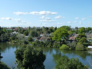
Hillcrest is a suburb in southeastern Hamilton in New Zealand. The suburb is home to the University of Waikato and consequently has a large student population. It is located on the east side of the Hamilton Town Belt, a series of public parks that run from the Hamilton Gardens to Ruakura in its eastern section.

<span class="mw-page-title-main">Chartwell, Hamilton</span> Suburb of Hamilton, New Zealand

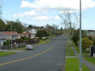
Chartwell is a suburb in north-eastern Hamilton, New Zealand. The suburb was named after Chartwell, the country home of Sir Winston Churchill. The area became a part of Hamilton in June 1962 and was officially defined as a suburb in 1974. Most of the housing is private single or 2 level dwellings with little state housing. Streets near the square are used for parking. Private dwellings are being purchased by professionals to be used as business premises close to the square. The streets are well planted with trees.

<span class="mw-page-title-main">Taupiri</span> Town in Waikato, New Zealand

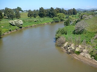
Taupiri is a small town of about 500 people on the eastern bank of the Waikato River in the Waikato District of New Zealand. It is overlooked by Taupiri mountain, the sacred burial ground for the Waikato tribes of the Māori people, located just to the north.

<span class="mw-page-title-main">Beerescourt</span> Suburb of Hamilton, New Zealand

Beerescourt is a suburb in western Hamilton, New Zealand. It is named after Capt. G. B. Beere, who was granted land in the military settlement at the conclusion of the New Zealand Wars. He set up a fort, and the area became known as Beere's Fort. The name was eventually changed to Beerescourt.

<span class="mw-page-title-main">Riverlea, New Zealand</span> Suburb of Hamilton, New Zealand

Riverlea is a suburb in south-eastern Hamilton in New Zealand. It is located south of Hillcrest. The suburb is primarily residential, with a small section of light industrial land along Riverlea Road.

<span class="mw-page-title-main">Enderley</span> Suburb of Hamilton, New Zealand

Enderley is a suburb of Hamilton, New Zealand. It became a part of Hamilton in the 5th boundary extension in 1949. It is the highest ranking suburb for socio-economic deprivation in eastern Hamilton.

<span class="mw-page-title-main">Hamilton West, New Zealand</span> Suburb of Hamilton, New Zealand

Hamilton West is a suburb in western Hamilton in New Zealand.

<span class="mw-page-title-main">Maeroa</span> Suburb of Hamilton, New Zealand

Maeroa is a suburb in western Hamilton in New Zealand. Originally an outlying suburb, it became part of Hamilton City in 1925 with the second boundary extension.

<span class="mw-page-title-main">Pukete</span> Suburb of Hamilton, New Zealand

Pukete is a 1970s riverside suburb in northwestern Hamilton in New Zealand.

<span class="mw-page-title-main">St Andrews, Hamilton</span> Suburb of Hamilton, New Zealand

St Andrews is a suburb in north-western Hamilton in New Zealand. One of its main features is an 18-hole golf course built on an old flood plain on the west bank of the Waikato River. This area was regularly flooded before the construction of the Karapiro HEP dam further up river.

<span class="mw-page-title-main">Fairview Downs</span> Suburb of Hamilton, New Zealand

Fairview Downs is a suburb in eastern Hamilton in New Zealand.

<span class="mw-page-title-main">Onewhero</span> Place in Waikato, New Zealand

Onewhero is a village and rural community in the Waikato District and Waikato region of New Zealand's North Island.

<span class="mw-page-title-main">Whatawhata</span> Town in Waikato, New Zealand

Whatawhata, previously also spelt Whata Whata, is a small town in the Waikato region on the east bank of the Waipā River, at the junction of State Highways 23 and 39, 12 km (7.5 mi) from Hamilton. Te Araroa tramping route passes through Whatawhata.

<span class="mw-page-title-main">Hillcrest, Rotorua</span> Suburb of Rotorua, New Zealand

Hillcrest is a suburb of Rotorua in the Bay of Plenty Region of New Zealand's North Island.

<span class="mw-page-title-main">River Road, Hamilton</span> Suburb of Hamilton, New Zealand

River Road is a residential suburb of Hamilton, sited on the eastern bank of the Waikato River. The namesake road runs from Claudelands Bridge north to Pukete Bridge and beyond, to Ngāruawāhia, but the main part of the suburb is between Boundary Road and Donny Park. Properties close to the river are much more expensive than those further away. Most of River Road was shown on an 1865 map, though it was some years later before it was built and, by 1866, only one bridge had been built.

References

  1. 1 2 "ArcGIS Web Application". statsnz.maps.arcgis.com. Retrieved 21 October 2022.
  2. 1 2 "Population estimate tables - NZ.Stat". Statistics New Zealand . Retrieved 25 October 2022.
  3. Street Name Index – Hamilton Public Library, Hamilton
  4. 1 2 "Statistical area 1 dataset for 2018 Census". Statistics New Zealand. March 2020. Silverdale (Hamilton City) (180800). 2018 Census place summary: Silverdale (Hamilton City)
  5. "Index of Socioeconomic Deprivation for Areas within the Hamilton East Electorate". Parliament New Zealand. Retrieved 31 October 2020.
  6. Education Counts: Hillcrest High School
  7. "Principal's Message". Hillcrest High School. Retrieved 31 October 2020.
  8. Education Counts: Silverdale Normal School
  9. "Silverdale Normal School: silver jubilee, 1964–1989 (collection record)". National Library. Retrieved 31 October 2020.
  10. "New Zealand Schools Directory". New Zealand Ministry of Education. Retrieved 12 December 2022.