
Hamilton is an inland city in the North Island of New Zealand. Located on the banks of the Waikato River, it is the seat and most populous city of the Waikato region. With a territorial population of 192,000, it is the country's fourth most-populous city. Encompassing a land area of about 110 km2 (42 sq mi), Hamilton is part of the wider Hamilton Urban Area, which also encompasses the nearby towns of Ngāruawāhia, Te Awamutu and Cambridge. In 2020, Hamilton was awarded the title of most beautiful large city in New Zealand. Hamilton is now considered the fastest growing city in the country.

Tīrau is a small town in the Waikato region of the North Island of New Zealand, 50 kilometres southeast of Hamilton. The town has a population of 804. In the Māori language, "Tīrau" means "place of many cabbage trees."
Ruakura is a semi-rural suburb of Hamilton City, in the Waikato region of New Zealand. The University of Waikato is nearby.

Cape Colville is the northernmost point of the Coromandel Peninsula in New Zealand's North Island. It lies 85 kilometres north of Thames, and 70 kilometres northeast of the city of Auckland, on the other side of the Hauraki Gulf. The small settlements of Port Jackson and Fletcher Bay lie immediately to the west and east respectively of the cape.

Te Rapa is a mixed light industrial, large-scale retail and semi-rural suburb to the northwest of central Hamilton, New Zealand that is built on a flat area that was previously the bed of an ancient river, the forerunner to the present Waikato River.

Hamilton East is a suburb in central Hamilton in New Zealand. The suburb's primary commercial and retail precinct is located along Grey Street. Hamilton East is characterised by villas and bungalows built early in the 20th century.

Flagstaff is a suburb in north-east Hamilton, New Zealand. It was originally called Dulverton on council plans, but it was officially named Flagstaff in 1986 when it was declared as a suburb. The area was heavily developed in the 1990s.

Rototuna is a suburb in northern Hamilton, New Zealand, east of Flagstaff. It is one of the newest and fastest-growing suburbs in Hamilton, along with neighbouring Huntington and Flagstaff.

Crawshaw is a compact suburb, close to Te Rapa railway depot, in western Hamilton in New Zealand, and extended in the 2018 census to cover 0.86 km2. Although sometimes referred to as a suburb in its own right, it is often described as being part of Nawton.

Pukete is a 1970s riverside suburb in northwestern Hamilton in New Zealand.
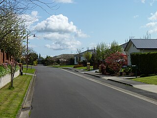
Stonebridge, also known as Stonebridge Estate, is a suburb close to the western boundary of Hamilton in New Zealand. It adjoins Dinsdale to the east and Western Heights to the north. The suburb was farmland until development began about 1996; a large farming operation still takes place in the land between sections today. The land is mainly rolling with a winding gully. Developers have modified the existing vegetation and landscape to create a series of ponds connected by a creek.
Callum Brae is a suburb in north-eastern Hamilton in New Zealand.

Harrowfield is a suburb in eastern Hamilton in New Zealand. It was built in about 1991.

Magellan Rise is a new suburb in north-eastern Hamilton in New Zealand. In the 2018 census it is at the boundaries of Flagstaff North, East and South areas and is described by others as Flagstaff.

Somerset Heights is a suburb in north-eastern Hamilton in New Zealand, often known as Huntington, or Rototuna. The name Rototuna is also often used to include Grosvenor, Callum Brae, Huntington and St James. Somerset Heights forms part of Te Manatu census area.
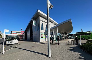
Public transport in Hamilton and the Waikato Region consists mainly of bus services, as well as some limited train and ferry services. Services are mainly infrequent, and investment hasn't been sufficient to compete with cars, so that subsidies, first introduced in 1971, have increased.

Marokopa is a rural community in Waitomo District and Waikato region of New Zealand. It is located close to the coast between Awakino and Kawhia Harbour. The meshblock includes the coastal township of Marokopa, at the mouth of the Marokopa River, and the south side of the small village of Awamarino, about 10 km (6.2 mi) upstream.

Tauwhare is a small rural community in the Waikato District on the outskirts of Hamilton. The Waitakaruru Arboretum and Sculpture Park is located here.
Te Anga is a rural community in the Waitomo District and Waikato region of New Zealand's North Island.

Waitetuna is a rural community in the Waikato District and Waikato region of New Zealand's North Island. It is located on the valley of the Waitetuna River, upstream from the Raglan Harbour.

