The Swan River is a major river in the south west of Western Australia. The river runs through the metropolitan area of Perth, Western Australia's capital and largest city.

Albany Highway links Western Australia's capital city Perth with its oldest settlement, Albany, on the state's south coast. The 405-kilometre-long (252 mi) highway travels through the southern Wheatbelt and Great Southern regions, and is designated State Route 30 for most of its length. Outside of Perth the highway is predominately a sealed, single carriageway with regular overtaking lanes in some undulating areas. Albany Highway commences at The Causeway, a river crossing that connects to Perth's central business district. The highway heads south-east through Perth's metropolitan region, bypassed in part by Shepperton Road and Kenwick Link, and continues south-eastwards through to Albany. It intersects several major roads in Perth, including the Leach, Tonkin, Brookton, and South Western highways. The rural section of Albany Highway connects to important regional roads at the few towns and roadhouses along the route, including Coalfields Highway at Arthur River, Great Southern Highway at Cranbrook, and Muirs Highway at Mount Barker.

Great Eastern Highway is a 590-kilometre-long (370 mi) road that links the Western Australian capital of Perth with the city of Kalgoorlie. A key route for road vehicles accessing the eastern Wheatbelt and the Goldfields, it is the western portion of the main road link between Perth and the eastern states of Australia. The highway forms the majority of National Highway 94, although the alignment through the Perth suburbs of Guildford and Midland, and the eastern section between Coolgardie and Kalgoorlie are not included. Various segments form parts of other road routes, including National Route 1, Alternative National Route 94, and State Route 51.
The Kwinana Freeway is a 72-kilometre (45 mi) freeway in and beyond the southern suburbs of Perth, Western Australia, linking central Perth with Mandurah to the south. It is the central section of State Route 2, which continues north as Mitchell Freeway to Clarkson, and south as Forrest Highway towards Bunbury. A 4-kilometre (2.5 mi) section between Canning and Leach highways is also part of National Route 1. Along its route are interchanges with several major roads, including Roe Highway and Mandjoogoordap Drive. The northern terminus of the Kwinana Freeway is at the Narrows Bridge, which crosses the Swan River, and the southern terminus is at Pinjarra Road, east of Mandurah.
The Mitchell Freeway is a 41.6-kilometre-long (25.8 mi) freeway in the northern suburbs of Perth, Western Australia, linking central Perth with the city of Joondalup. It is the northern section of State Route 2, which continues south as Kwinana Freeway and Forrest Highway. Along its length are interchanges with several major roads, including the Graham Farmer Freeway and Reid Highway. The southern terminus of the Mitchell Freeway is at the Narrows Bridge, which crosses the Swan River, and the northern terminus is at Romeo Road in Alkimos, a suburb within the City of Wanneroo.
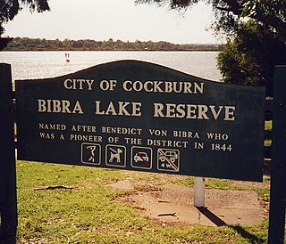
Bibra Lake is a suburb of Perth, Western Australia; it takes its name from the extensive freshwater lake within its boundaries, Bibra Lake. It is located within the City of Cockburn and its postcode is 6163.

Roe Highway is a 35-kilometre-long (22 mi) limited-access highway and partial freeway in Perth, Western Australia, linking Kewdale with the city's north-eastern and south-western suburbs. The northern terminus is at Reid Highway and Great Northern Highway in Middle Swan, and the southern terminus is with Murdoch Drive at the Kwinana Freeway interchange in Bibra Lake. Roe Highway, in addition to Reid Highway, form State Route 3, a partial ring road around the outer suburbs of the Perth metropolitan area. Roe Highway also forms part of National Highway 94 from Great Eastern Highway Bypass to Great Eastern Highway, and National Highway 95 from Great Eastern Highway to Great Northern Highway.

Tonkin Highway is an 81-kilometre-long (50 mi) north–south highway and partial freeway in Perth, Western Australia, linking Perth Airport and Kewdale with the city's north-eastern and south-eastern suburbs. As of April 2020, the northern terminus is at the interchange with Brand Highway and Great Northern Highway in Muchea, and the southern terminus is at Thomas Road in Oakford. It forms the entire length of State Route 4, and connects to several major roads. Besides Brand Highway and Great Northern Highway, it also connects to Reid Highway, Great Eastern Highway, Leach Highway, Roe Highway, and Albany Highway.

Leach Highway is a 23-kilometre (14 mi) east-west arterial highway in the southern suburbs of Perth, Western Australia, primarily linking Kewdale and Perth Airport with the city of Fremantle.

Stirling Highway is, for most of its length, a four-lane single carriageway and major arterial road between Perth, Western Australia and the port city of Fremantle in Western Australia on the northern side of the Swan River. The speed limit is 60 km/h (37 mph). East of Crawley, it continues as Mounts Bay Road which links Crawley and the nearby University of Western Australia to the Perth central business district.

Great Eastern Highway Bypass is a limited-access dual carriageway linking Great Eastern Highway and Roe Highway in Perth, Western Australia. Together with a section of Roe Highway, it bypasses the historical Guildford and Midland localities, through which the original, urban and slower Great Eastern Highway passes.
Toodyay Road is a mostly 2-lane undivided single carriageway in Western Australia, running from the north-eastern Perth suburb of Middle Swan, through Gidgegannup and Bailup, to the Wheatbelt town of Toodyay. It is signposted as State Route 50.
The Beeliar Wetlands is a wetland located in the southwest portion of Western Australia. It is made up of two chains of lakes and wetlands that run parallel to the west coast of Australia. They are situated on the Swan Coastal Plain between the Darling Escarpment and the Indian Ocean. Beeliar was the name given to the area by the Aboriginal people that lived and hunted in the area.
Transport in Perth, Western Australia, is served by various means, among them an extensive highway / freeway network and a substantial system of commuter rail lines and bus routes. Public transport is managed by the Transperth agency.
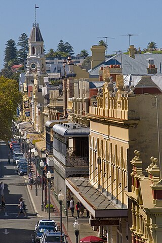
High Street is the main street running through the City of Fremantle, Western Australia. The street passes by historic landmarks, including the Round House, the Fremantle Town Hall, and the Fremantle War Memorial, through the Fremantle West End Heritage area and through two town squares. Trams operated along High Street for 47 years, between 1905 and 1952. Running east–west, High Street continues as Leach Highway, a major arterial road, at Stirling Highway, linking Fremantle with Perth Airport although the stretch of road between Stirling Highway and Carrington Street is known locally—and signed—as High Street.
The Perth Freight Link was a proposed $1.9 billion project in Perth, Western Australia to improve the road freight link between Kewdale and Fremantle Harbour. The project was announced by the state government in May 2014, but was cancelled following a change of government at the March 2017 state election.
Stephenson Avenue refers to two separate sections of road in the western suburbs of Perth, Western Australia.

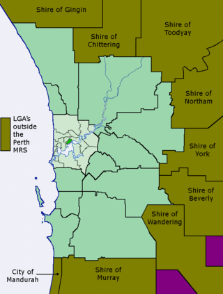
The 1955 Plan for the Metropolitan Region, Perth and Fremantle was prepared for the Government of Western Australia by Gordon Stephenson and Alistair Hepburn. The plan was the first regional plan for Perth, and provided the basis for land use zoning under the Metropolitan Region Scheme. Even though not every recommendation of the report was adopted it is considered to have provided the underlying template for the modern development of Perth. The plan was superseded by the Corridor Plan for Perth in 1970.