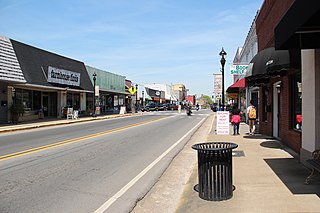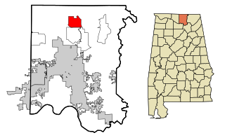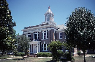
Limestone County is a county of the U.S. state of Alabama. As of the 2020 census, the county's population was 103,570. Its county seat is Athens. The county is named after Limestone Creek. Limestone County is included in the Huntsville, AL Metropolitan Statistical Area.

Madison County is a county located in the north central portion of the U.S. state of Alabama. As of the 2020 Census, the population was 388,153, making it the second-most populous county in Alabama. Its county seat is Huntsville. Since the mid-20th century it has become an area of defense and space research and industry.

Fort Payne is a city in and county seat of DeKalb County, in northeastern Alabama, United States. At the 2020 census, the population was 14,877.

Huntsville is the most populous city in the U.S. state of Alabama. It is the county seat of Madison County with portions extending into Limestone County and Morgan County. It is located in the Appalachian region of northern Alabama south of the state of Tennessee.

Madison is a city located primarily in Madison County, near the northern border of the U.S. state of Alabama. Madison extends west into neighboring Limestone County. The city is included in the Huntsville Metropolitan Area, the second-largest in the state, and is also included in the merged Huntsville-Decatur Combined Statistical Area. The population was 56,933 at the 2020 census. Madison is bordered by Huntsville on nearly all sides with some small unincorporated lands within Madison in Madison and Limestone counties.

Hazel Green is an unincorporated community and census-designated place (CDP) in Madison County, Alabama, United States, and is included in the Huntsville-Decatur Combined Statistical Area. As of the 2020 census, the population of the community was 4,105, up from 3,630 at the 2010 census.

Rison, officially the City of Rison, is a city in and the county seat of Cleveland County, Arkansas, United States. Its population was 1,344 at the 2010 U.S. census. It is included in the Pine Bluff, Arkansas Metropolitan Statistical Area. Rison is a bedroom community for people who work in Pine Bluff. The largest employers are the city and county governments, the Cleveland County School District, the Cleveland County Nursing Home. There are two banks, eight churches, and about forty-five businesses within the city limits. Among the local properties listed on the National Register of Historic Places are the Rison Cities Service Station and the Rison Texaco Service Station.

Huntsville is a city in and the county seat of Madison County, Arkansas, United States. The population was 2,879 at the 2020 census, up from 2,346 in 2010. During the American Civil War in 1862, it was the site of what became known as the Huntsville Massacre. Huntsville is part of the Northwest Arkansas region.

Huntsville is a city in Randolph County, Missouri, United States. The population was 1,376 at the 2020 census. It is the county seat of Randolph County.

Huntsville is a city in and the county seat of Walker County, Texas, United States. The population was 45,941 as of the 2020 census. It is the center of the Huntsville micropolitan area. Huntsville is in the East Texas Piney Woods on Interstate 45 and home to Sam Houston State University, Texas State Prison, the Texas Department of Criminal Justice, Huntsville State Park, and HEARTS Veterans Museum of Texas.

Clement Comer Clay was the eighth Governor of the U.S. state of Alabama from 1835 to 1837. An attorney, judge, and politician, he was elected to the state legislature as well as the U.S. House of Representatives and the United States Senate.
Lacey's Spring is an unincorporated community in northeastern Morgan County, Alabama, United States at the base of Brindlee Mountain. It is included in the Decatur Metropolitan Area, as well as the Huntsville-Decatur Combined Statistical Area. It is located south of Huntsville's Land within Morgan County.

The Tennessee Valley is the drainage basin of the Tennessee River and is largely within the U.S. state of Tennessee. It stretches from southwest Kentucky to north Alabama and from northeast Mississippi to the mountains of Virginia and North Carolina. The border of the valley is known as the Tennessee Valley Divide. The Tennessee Valley contributes greatly to the formation of Tennessee's three legally recognized sectors.

The Huntsville–Decatur–Albertville, Alabama, combined statistical area is the most populated sub-region of North Alabama, and is the second largest combined statistical area in the State of Alabama after Birmingham. The Huntsville-Decatur-Albertville CSA had a total of 879,315 people in 2022 and ranks 68th in the country.
Monrovia, also known as Vaughn Corners or Thompson Mill, is an unincorporated community in Madison County, Alabama, United States. It is bordered on the south by the city of Madison, on the southeast by the city of Huntsville, on the west by Limestone County and on the north by the community of Harvest.

The Huntsville Metropolitan Statistical Area is a metropolitan statistical area on the northern border of Alabama. The metro area's principal city is Huntsville, and consists of two counties: Limestone and Madison. As of the 2020 United States census, the Huntsville Metropolitan Area's population was 491,723, making it the 2nd-largest metropolitan area in Alabama and the 113th-largest in the United States.
Big Cove is an unincorporated community in Madison County, Alabama, United States. It is located roughly seven miles southeast of downtown Huntsville. Big Cove also encompasses the growing community of Hampton Cove. The community of Big Cove does not have its own address. The address is shared with the town Owens Cross Roads located roughly 10 miles southeast of Big Cove and shared address with Huntsville.

CSS Huntsville was a Confederate ironclad floating battery built at Selma, Alabama, from 1862 to 1863 during the American Civil War.
Madison County Schools is a school district in Madison County, Alabama, United States, headquartered in an unincorporated area, bordering Huntsville.


