Frenchay Road

Last updated

View east along Frenchay Road at the junction with Hayfield Road. Frenchay Road, Oxford.JPG
View east along Frenchay Road at the junction with Hayfield Road.
Houses on the north side of the old part of Frenchay Road. Houses in Frenchay Road, Oxford.JPG
Houses on the north side of the old part of Frenchay Road.

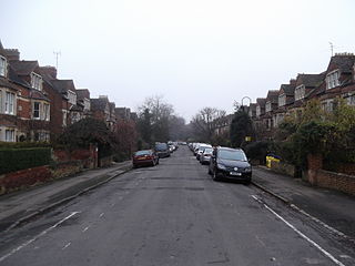
Frenchay Road is a residential road in Walton Manor, North Oxford, England. [1]

The oldest part of the road runs east–west. At the eastern end is a junction with Woodstock Road (A4144), a major arterial road out of Oxford to the north. Opposite and slightly to the south is Staverton Road. Chalfont Road leads south from halfway along the original part of the road. To the west is a junction with Bainton Road to the north and Hayfield Road to the south. The road continued over the Frenchay Road Bridge on the Oxford Canal, formerly to commercial premises by the railway line. [2] More recently the road has been extended to the west of the canal with a bend to the north and newer residential development, The Waterways housing estate [3] dating from 2000 to 2006, doubling the length of the road. Immediately to the southwest of Frenchay Road Bridge on the canal is the entrance to the Trap Grounds nature reserve.

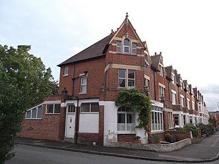
All the original houses were designed by the leading North Oxford architect Harry Wilkinson Moore and were first leased between 1897 and 1906. [1] Many were built by John Money. The road forms the approximate northern boundary of the original North Oxford development by St John's College, Oxford, along with Staverton Road and Marston Ferry Road to the east. [4] The original houses were semi-detached residences. [5] Newer homes are flats, maisonettes, and terraced houses. [6]

The Scottish educational missionary to Calcutta and Orientalist John Nicol Farquhar (1861–1929) lived at 11 Frenchay Road. [7] The road is mentioned in the book A Death in Oxford by Richard MacAndrew. [8]

Related Research Articles

Whittle-le-Woods Human settlement in England

Whittle-le-Woods is a village and civil parish of the Borough of Chorley in Lancashire, England. The population of the civil parish at the 2011 census was 5,434.

North Oxford Human settlement in England

North Oxford is a suburban part of the city of Oxford in England. It was owned for many centuries largely by St John's College, Oxford and many of the area's Victorian houses were initially sold on leasehold by the College.

Woodstock Road, Oxford

Woodstock Road is a major road in Oxford, England, running from St Giles' in the south, north towards Woodstock through the leafy suburb of North Oxford. To the east is Banbury Road, which it meets at the junction with St Giles'.

Worcester Street Street in west central Oxford, England

Worcester Street is a street in west central Oxford, England.

<span class="mw-page-title-main">Chalfont Road</span> Road in North Oxford, England

Chalfont Road is a road in Walton Manor, North Oxford, England.

<span class="mw-page-title-main">Lathbury Road</span> Road in North Oxford, England

Lathbury Road is a short residential road in north Oxford, England.

Rawlinson Road

Rawlinson Road is a residential road in North Oxford, England.

<span class="mw-page-title-main">Staverton Road</span> Street in North Oxford, England

Staverton Road is a residential road in North Oxford, England.

<span class="mw-page-title-main">Bainton Road</span> Road in North Oxford, England

Bainton Road is a residential road in north Oxford, England.

<span class="mw-page-title-main">Farndon Road</span> Road in North Oxford, England

Farndon Road is a residential road in North Oxford, England.

Waterways, Oxford Human settlement in England

The Waterways is housing estate in North Oxford, England. The Oxford Canal runs through the centre of the estate and it is bounded on the east by the Cherwell Valley railway line. To the west beyond the railway line are Port Meadow and the River Thames. The estate begins in the south as a continuation of Frenchay Road, part of Victorian North Oxford, and as Elizabeth Jennings Way connects with the Woodstock Road (A4144) at the northern end of the estate.

<span class="mw-page-title-main">Walton Well Road</span>

Walton Well Road is a road, about 400 metres long, near the centre of Oxford, England. It provides a link from central Oxford to Port Meadow.

Hayfield Road Road in Oxford

Hayfield Road is a residential road that runs north-south in Walton Manor, north Oxford, England.

<span class="mw-page-title-main">Fyfield Road</span> Road in North Oxford, England

Fyfield Road is a residential road in North Oxford, England, on the Norham Manor estate.

Warnborough Road

Warnborough Road is a residential road in North Oxford, England.

Southmoor Road

Southmoor Road is a residential road in Walton Manor, north Oxford, England.

<span class="mw-page-title-main">Longworth Road</span> Road in North Oxford, England

Longworth Road is a residential road in Walton Manor, North Oxford, England.

Rewley Road

Rewley Road is in the west of central Oxford, England. It is located in St Thomas's parish.

<span class="mw-page-title-main">Juxon Street</span> Street in Jericho, Oxford, England

Juxon Street is a street in the north of Jericho, an inner suburb of Oxford, England.

<span class="mw-page-title-main">Canal Street, Oxford</span> Street in Jericho, Oxford, England

Canal Street is a residential street in Jericho, an inner suburb of Oxford, England, northwest of the city centre.

References

  1. 1 2 Hinchcliffe, Tanis (1992). North Oxford. New Haven & London: Yale University Press. pp. 85, 123, 224. ISBN   0-14-071045-0.
  2. "Frenchay Road". Kelly's Directory of Oxford. Kelly's Directories. 1976. pp. 337–338.
  3. "About the Waterways". www.thewaterways.co.uk. Oxford, UK: The Waterways. Retrieved 6 September 2012.
  4. Hibbert, Christopher, ed. (1988). "North Oxford". The Encyclopaedia of Oxford . Macmillan. pp. 282–284. ISBN   0-333-39917-X.
  5. Symonds, Ann Spokes (1998). "The Outward Face of Walton Manor". The Changing Faces of North Oxford. Vol. Book Two. Robert Boyd Publications. p. 33. ISBN   1 899536 33 7.
  6. "Sold House Prices in Frenchay Road". Oxford Mail . Retrieved 6 September 2012.
  7. Farquhar, J.N. (1984). "Foreword". Outline of the Religious Literature of India. Motilal Banarsidass. p. xiv. ISBN   978-8120820869.
  8. MacAndrew, Richard (2007). A Death in Oxford. Cambridge English Readers. Cambridge University Press. p. 11. ISBN   978-0521704649.

Coordinates: 51°46′13″N1°16′06″W / 51.7704°N 1.2684°W / 51.7704; -1.2684